Download as PDF, PPTX
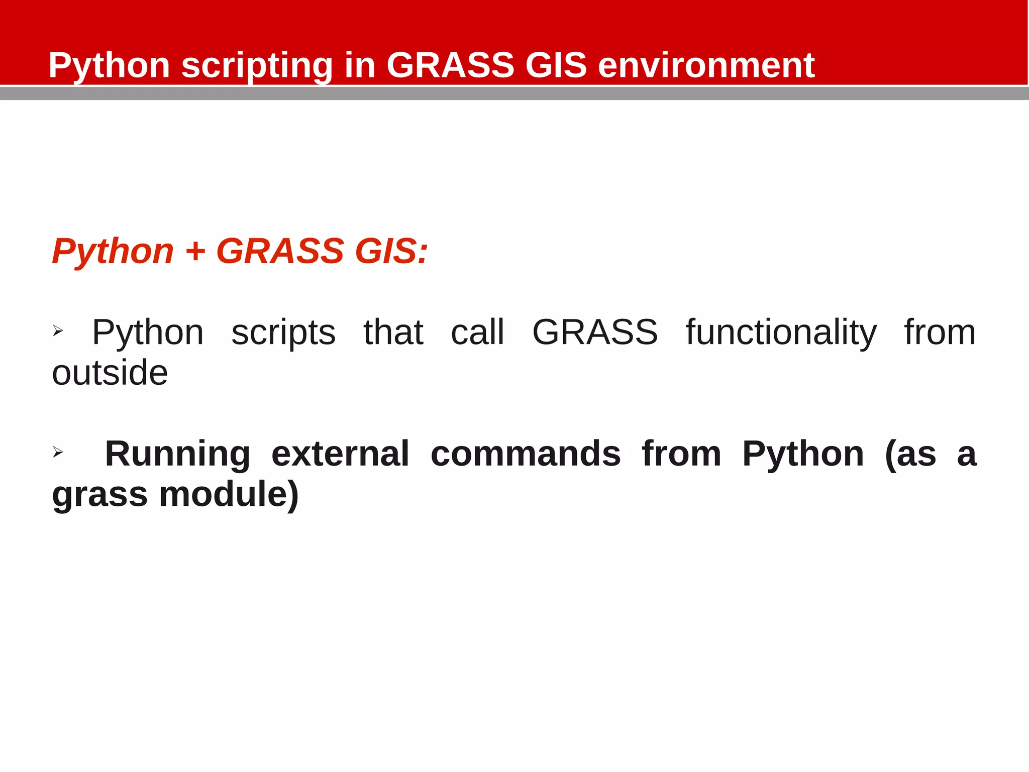
![Python scripting in GRASS GIS environment
prompt
GRASS 6.5.svn (Basilicata):~ > r.ipso.py --help
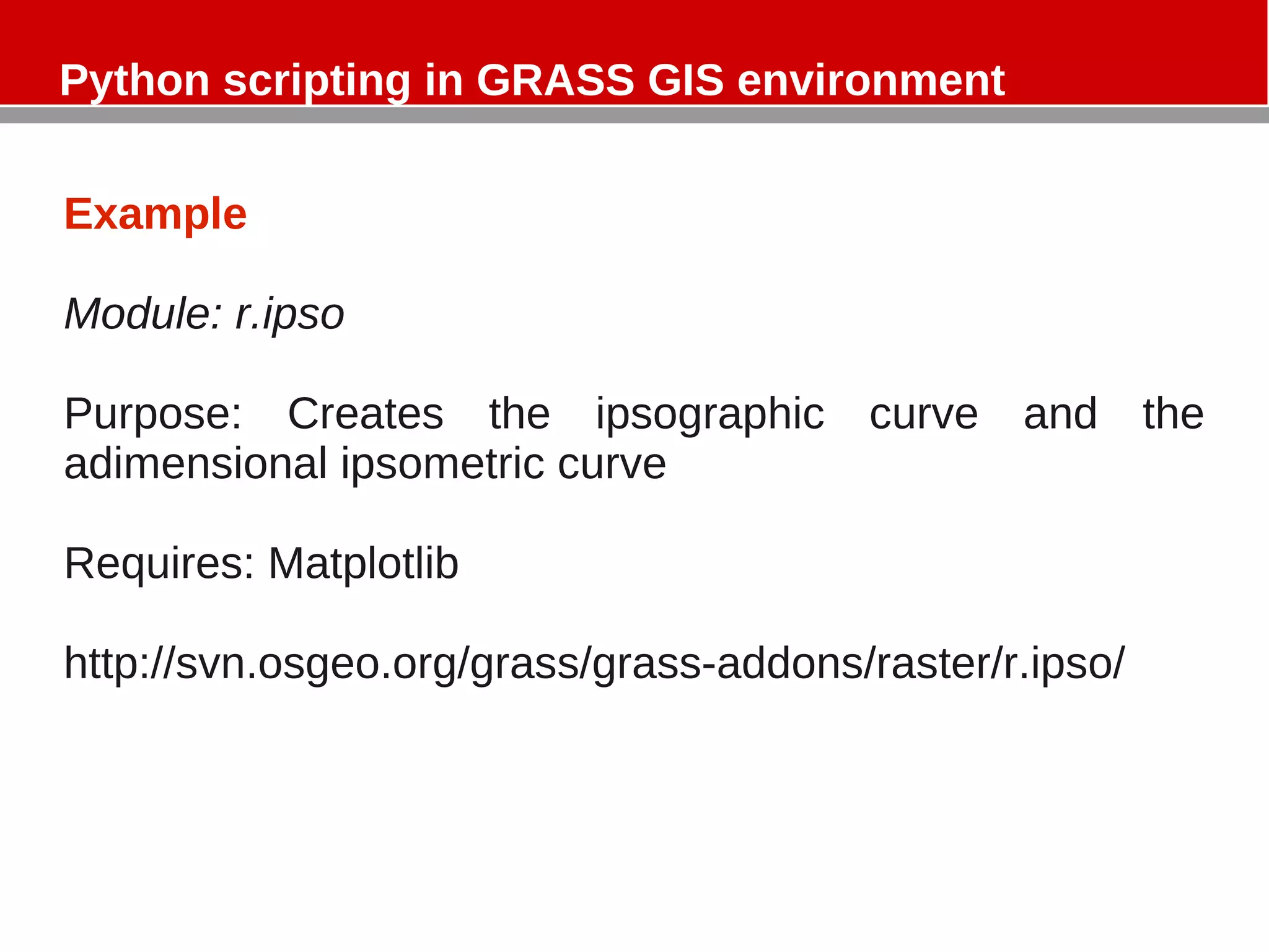
Description:
Creates the ipsographic and ipsometric curve
Keywords:
raster
Usage:
r.ipso.py [-ab] map=name image=image [--verbose] [--quiet]
Flags:
-a generate ipsometric curve
-b generate ipsographic curve
--v Verbose module output
--q Quiet module output
Parameters:
map Name of elevation raster map
image path to output graph
GRASS 6.5.svn (Basilicata):~ >](https://image.slidesharecdn.com/python-grass-101204132614-phpapp01/75/Python-grass-6-2048.jpg)
![Python scripting in GRASS GIS environment
import
import sys
import os
import matplotlib.pyplot as plt
import grass.script as grass
import numpy as np
Main (1/4)
def main():
# r.stats gives in the first column the elevation and in the second the number of
cells having that elevation
stats = grass.read_command('r.stats', input = options['map'], fs = 'space', nv =
'*', nsteps = '255', flags = 'inc').split('n')[:-1]
# res = cellsize
res = float(grass.read_command('g.region', rast = options['map'], flags =
'm').strip().split('n')[4].split('=')[1])
zn = np.zeros((len(stats),6),float)
kl = np.zeros((len(stats),2),float)
prc = np.zeros((9,2),float)
for i in range(len(stats)):
if i == 0:
zn[i,0], zn[i, 1] = map(float, stats[i].split(' '))
zn[i,2] = zn[i,1]
else:
zn[i,0], zn[i, 1] = map(float, stats[i].split(' '))
zn[i,2] = zn[i,1] + zn[i-1,2]
totcell = sum(zn[:,1])
print "Tot. cells", totcell](https://image.slidesharecdn.com/python-grass-101204132614-phpapp01/75/Python-grass-10-2048.jpg)
![Python scripting in GRASS GIS environment
Main (2/4)
for i in range(len(stats)):
zn[i,3] = 1 - (zn[i,2] / sum(zn[:,1]))
zn[i,4] = zn[i,3] * (((res**2)/1000000)*sum(zn[:,1]))
zn[i,5] = ((zn[i,0] - min(zn[:,0])) / (max(zn[:,0]) - min(zn[:,0])) )
kl[i,0] = zn[i,0]
kl[i,1] = 1 - (zn[i,2] / totcell)
# quantiles
prc[0,0] , prc[0,1] = findint(kl,0.025) , 0.025
prc[1,0] , prc[1,1] = findint(kl,0.05) , 0.05
prc[2,0] , prc[2,1] = findint(kl,0.1) , 0.1
prc[3,0] , prc[3,1] = findint(kl,0.25) , 0.25
prc[4,0] , prc[4,1] = findint(kl,0.5) , 0.5
prc[5,0] , prc[5,1] = findint(kl,0.75) , 0.75
prc[6,0] , prc[6,1] = findint(kl,0.9) , 0.9
prc[7,0] , prc[7,1] = findint(kl,0.95) , 0.95
prc[8,0] , prc[8,1] = findint(kl,0.975) , 0.975
# Managing flag & plot
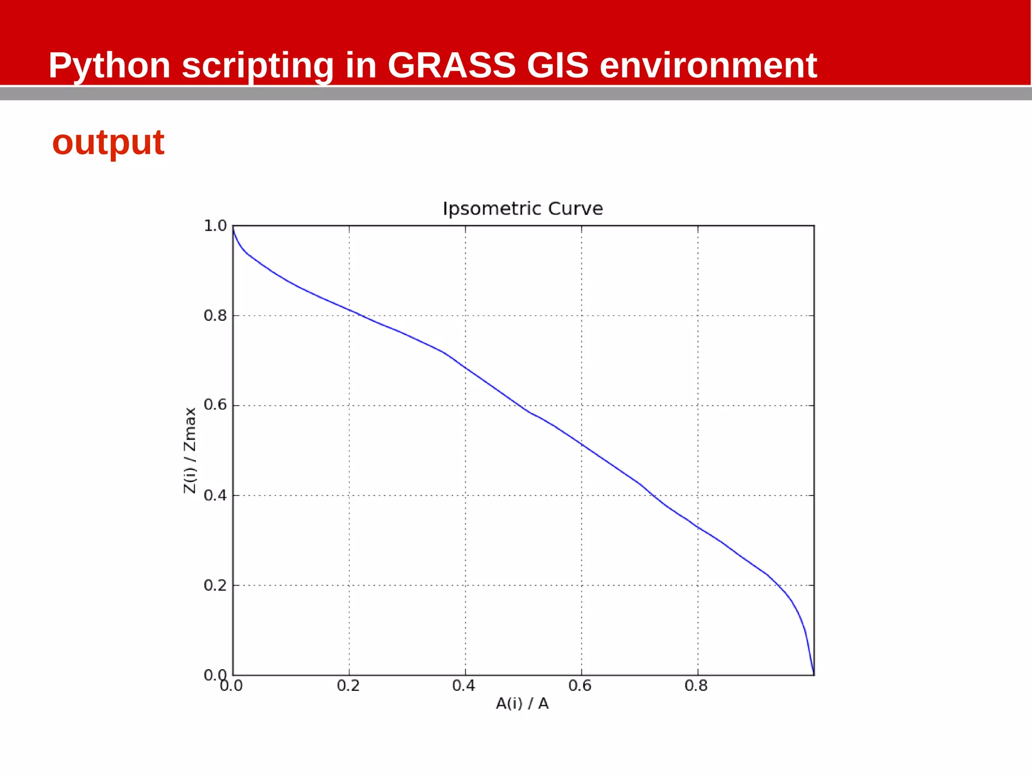
if flags['a']:
plotImage(zn[:,3], zn[:,5],options['image']+'_Ipsometric.png','-','A(i) /
A','Z(i) / Zmax','Ipsometric Curve')
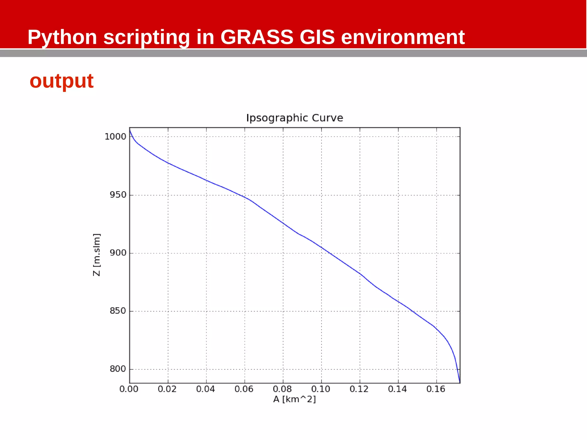
if flags['b']:
plotImage(zn[:,4], zn[:,0],options['image']+'_Ipsographic.png','-','A [km^2
]','Z [m.slm]','Ipsographic Curve')](https://image.slidesharecdn.com/python-grass-101204132614-phpapp01/75/Python-grass-11-2048.jpg)
![Python scripting in GRASS GIS environment
Main (3/4)
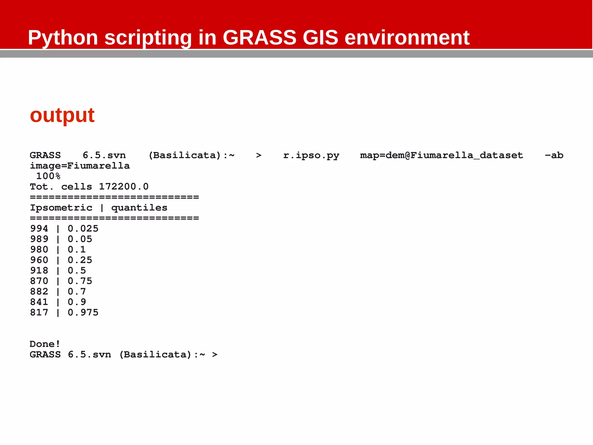
print "==========================="
print "Ipsometric | quantiles"
print "==========================="
print '%.0f' %findint(kl,0.025) , "|", 0.025
print '%.0f' %findint(kl,0.05) , "|", 0.05
print '%.0f' %findint(kl,0.1) , "|", 0.1
print '%.0f' %findint(kl,0.25) , "|", 0.25
print '%.0f' %findint(kl,0.5) , "|", 0.5
print '%.0f' %findint(kl,0.75) , "|", 0.75
print '%.0f' %findint(kl,0.7) , "|", 0.7
print '%.0f' %findint(kl,0.9) , "|", 0.9
print '%.0f' %findint(kl,0.975) , "|", 0.975
print 'n'
print 'Done!'
#print prc
def findint(kl,f):
Xf = np.abs(kl-f); Xf = np.where(Xf==Xf.min())
z1 , z2 , f1 , f2 = kl[float(Xf[0])][0] , kl[float(Xf[0]-1)][0] , kl[float(Xf[0])
][1] , kl[float(Xf[0]-1)][1]
z = z1 + ((z2 - z1) / (f2 - f1)) * (f - f1)
return z](https://image.slidesharecdn.com/python-grass-101204132614-phpapp01/75/Python-grass-12-2048.jpg)
![Python scripting in GRASS GIS environment
Zn has n rows and 6 columns [len(stats) = n]
Kl has n rows and 2 columns
Prc has 9 rows and 2 columns
Zn
0 1 2 3 4 5
A= B= C = (if i=0, D = (1-C) / E = Di * F = (A –
elevation numbers of Ci=Ai; else numbers of (res^2) / min(A)) /
cells Ci = Ai + B(i- cells 1000000 * (max(A) -
1) ) numbers of min(A))
cells](https://image.slidesharecdn.com/python-grass-101204132614-phpapp01/75/Python-grass-14-2048.jpg)
![Python scripting in GRASS GIS environment
Zn has n rows and 6 columns [len(stats) = n]
Kl has n rows and 2 columns
Prc has 9 rows and 2 columns
kl
0 1
A= G = 1 – (C /
elevation num of cell)](https://image.slidesharecdn.com/python-grass-101204132614-phpapp01/75/Python-grass-15-2048.jpg)
![Python scripting in GRASS GIS environment
Prc has 9 rows and 2 columns.
It defines the ipsometric curve by the quantiles of the distribution.
It is built by the function ”findint”
def findint(kl,f):
Xf = np.abs(kl-f); Xf = np.where(Xf==Xf.min())
z1 , z2 , f1 , f2 = kl[float(Xf[0])][0] , kl[float(Xf[0]-1)][0] , kl[float(Xf[0])
][1] , kl[float(Xf[0]-1)][1]
z = z1 + ((z2 - z1) / (f2 - f1)) * (f - f1)
return z
np.abs and np.where are two NumPy routines:
numpy.absolute(x[, out])
Calculate the absolute value element-wise.
numpy.where(condition[, x, y])
Return elements, either from x or y, depending on condition.
If only condition is given, return condition.nonzero().
See NumPy doc at http://docs.scipy.org/doc/](https://image.slidesharecdn.com/python-grass-101204132614-phpapp01/75/Python-grass-16-2048.jpg)

The document describes a Python module called r.ipso that is used in GRASS GIS to generate ipsographic and ipsometric curves from raster elevation data. The module imports GRASS and NumPy libraries, reads elevation and cell count statistics from a raster, calculates normalized elevation and area values, and uses these to plot the curves and output quantile information. The module demonstrates calling GRASS functionality from Python scripts.