Current Weather Outlook
Statewide weather outlook from Florida Division of Emergency Management Meteorology
Tuesday, February 3, 2026
...2026 Severe Weather Awareness Week! Tuesday's Focus is on Rip Currents and Marine Conditions...
...Chilly Morning Across the State With Conditions Slowly Warming Up...Pleasant Conditions Return Statewide With Plenty of Sunshine...Elevated Wildfire Conditions for Northeast and Central Florida Continue...Rain Chances Return Tonight for the Panhandle With Next Cold Front...Cooler Night for Northeast Florida With Patchy Frost Possible Thorugh Central Florida...Elevated Rip Current Risk Persists; High Surf Advisory for Palm Beach County...
Updated at 9:38 AM EST
Today's Threats:
|
No Threat |
Low Threat |
Medium Threat |
High Threat |
|
Lightning |
Tornado |
Damaging Wind/Hail |
Wildfire |
Coastal Flooding |
Freeze (Overnight) |
Wind Chills (Overnight) |
Rip Currents |
|
NE & Central FL Statewide |
Locally Northeast FL & North-Central FL |
Locally Northeast FL & North-Central FL |
Space & Treasure Coast North & Southwest FL West Coast |
![]()
Weather Summary for the Next 24 Hours:
One more chilly start to the morning across the Sunshine State as conditions continue to gradually improve today from the brutally cold weekend. Freeze Warnings and Cold Weather Advisories for much of the state will gradually expire through the mid-morning hours as temperatures steadily rise. High pressure centered over the state will slowly drift eastward but continue to promote dry conditions throughout the day. Relative humidity values for Northeast and Central Florida will fall back into critical thresholds (20-30%) this afternoon, but lighter winds are expected today. However, with ongoing drought conditions elevated wildfire conditions will persist. Relative humidity values should recover for the rest of the state gradually. High temperatures will return to the 60s across the state this afternoon.

Cool conditions can be expected tonight, but not anywhere as cold as they have been. The area of high pressure will continue to push eastward as our next cold front approaches from the west this evening and overnight. This cold front will bring scattered to widespread showers to the Panhandle by the early morning hours on Wednesday (45-75% chance of rain). For the rest of the state calm conditions can be expected, with instances of frost possible along Northeast and Central Florida. Frost Advisories may be needed, but confidence is too low to say for sure. Calmer conditions also means instances of fog may be possible throughout the Suwannee Valley early Wednesday morning. For the first time in several days, cold weather watches and warnings are not expected tonight. Low temperatures will fall into the middle to upper 30s for Northeast Florida, 40s across the rest of North and Central Florid and upper 40s to upper 50s across South Florida. Feels-like temperatures will remain in the lower 30s for the Suwannee Valley near sunrise on Wednesday.

![]()

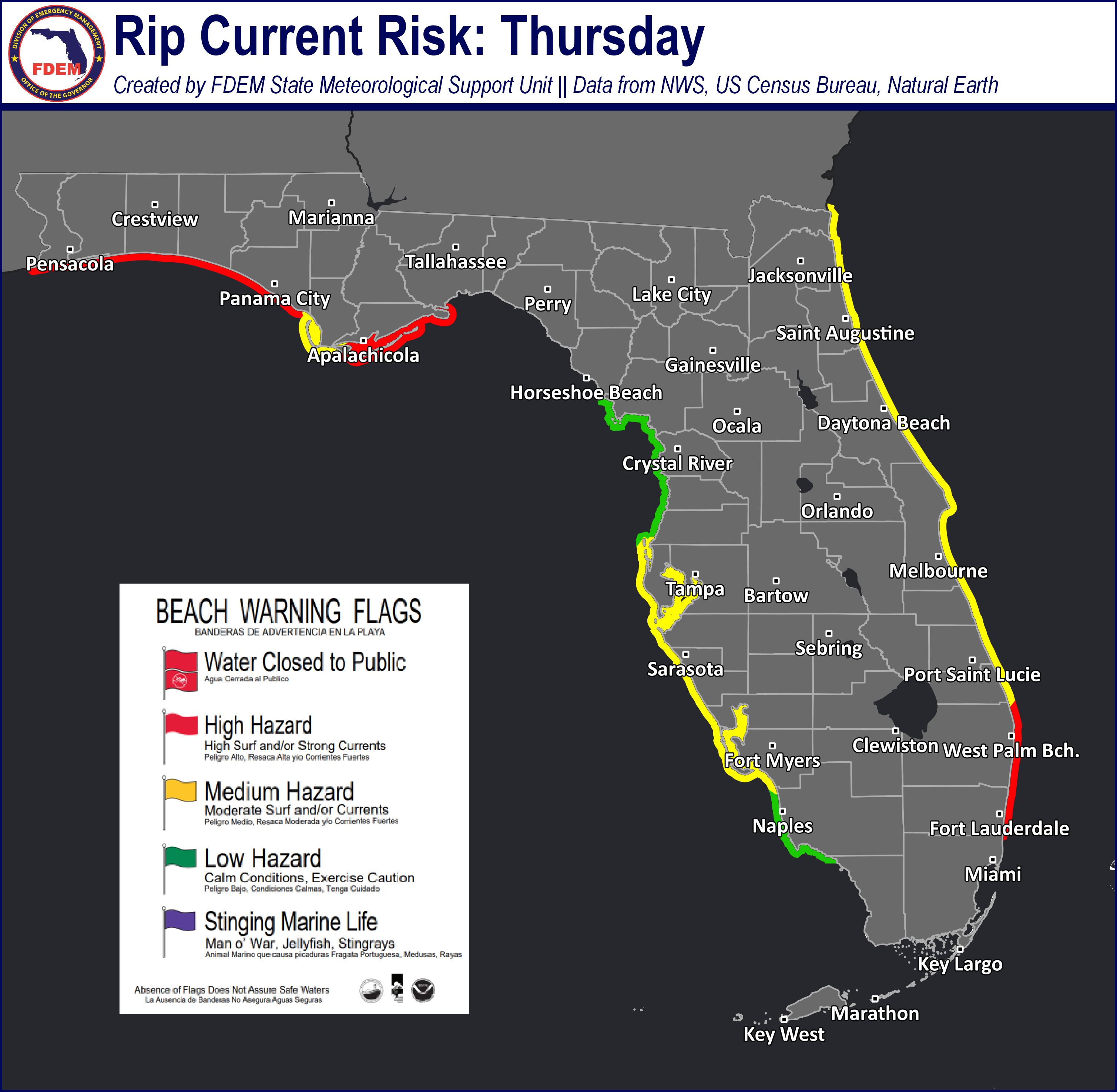
Rip Currents: Onshore winds and lingering ocean swells along the Space and Treasure Coasts will continue to create a high risk for rip currents. A moderate risk continues for much of North and Southwest Florida as winds return onshore for the Panhandle. A low risk returns for most of the West Coast. For the latest Rip Current Outlook, visit www.weather.gov/beach.
Marine Hazards: Wave heights of 3-5’ will continue along the East Coast throughout the day, with Treasure Coast beaches seeing wave heights upwards of 6-8’. A High Surf Advisory remains in effect along Palm Beach County through late this afternoon for dangerous beach and boating conditions. Panhandle and West Coast beaches will see wave action near 1-2’.
Red Tide was observed at background to very low concentrations in Walton County, background to medium concentrations in Bay County, and low concentrations in Gulf County across the Panhandle. In Southwest Florida, red tide was observed at background to very low concentrations offshore Hillsborough and Lee County. Along the Florida East Coast, red tide was observed at background concentrations from Balm Beach County (valid 1/31/2026).
Coastal Flooding: There is no risk for coastal flooding today.
![]()
Fire Weather: Dry air continues to linger throughout the state with the help of high pressure. Relative humidity values for Northeast and Central Florida will fall back into critical thresholds (20-30%) this afternoon leading to an elevated wildfire risk. Relative humidity values slowly being to recover for the Panhandle ahead of an approaching cold front bringing showers activity overnight. A much lighter wind regime can be expected today as high pressure sits over the Sunshine State. Wind gusts are expected to remain light near 10 mph for most of the state, with the Panhandle seeing gusts upwards of 15 mph. Instances of patchy fog may be possible over the Suwannee River Valley early Wednesday morning. As well instances of frost may be possible for Northeast and Central Florida. According to the Florida Forest Service, there are 104 active wildfires across the state burning approximately 2,956 acres.

Drought (1/29/26): We saw the greatest rainfall over the past week mainly across the Panhandle and north of the I-10 corridor with our frontal passage last weekend (1/25). Here rainfall totals of 0.5-2” fell, yet the ongoing long-term drought was hardly impacted. On the latest Drought Monitor outlook, severe drought (level 2 of 4) persists across much of North Florida and the I-10 corridor, expanding eastward to include the entire First Coast. Long-term (60 day) rainfall departures across the Nature Coast and North-Central Florida have neared 3-4” below normal, which has prompted the addition of an extreme drought (level 3 of 4) category. The extreme drought also remains untouched across the northern Big Bend region where, despite some rainfall, soil moisture levels and streamflows are well below normal. Across Central and South Florida, very little changes were made to this week’s outlook. Some slight expansion of the severe drought (level 2 of 4) was added across coastal Palm Beach and Martin counties where rainfall departures continue to dip below normal. Some slight improvement in drought conditions were found along the immediate Southeast Florida coastline with recent coastal shower activity. As of this outlook, 94% of the state is under a moderate drought (level 1 of 4) or worse.
The Keetch-Byram Drought Index average for Florida is 480 (+/-1) on a scale from 0 (very wet) to 800 (very dry). There are 32 Florida counties that have an average KBDI above 500 (drought/increased fire danger).
![]()
Flash Flooding: There is no risk for flash flooding today.

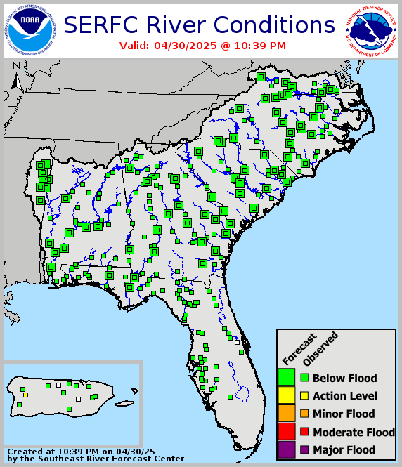
Riverine Flooding: There are no riverine concerns across Florida. For more information, visit the River Forecast Center.
Lake Okeechobee’s average elevation is 12.67 feet, which is within the operational band and is 1.98 feet below normal for this time of year.