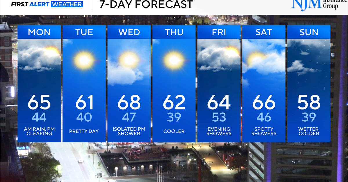
Quiet pattern settles in with a warm-up on the way

Temperature whiplash is on the way this week, with some mornings in the 30s and other afternoons in the 60s to lower 70s.
After a day with some rain to start, clearing skies and mild temperatures, we're in for a quieter day on Tuesday in Maryland.
Quieting down after changeable weather Monday
Early morning rainfall across Maryland was mainly confined to areas along and east of I-95. Rainfall totals were at a quarter inch or less in most areas, with a few neighborhoods seeing about a third of an inch on the Eastern Shore.
Sunset was at 5:03 p.m. Monday.
Prepare for a chilly night under clear skies.
Up and down temperatures this week
As expected in the middle of the autumn season, big temperature swings are on the way for Maryland.
Tuesday will be a quieter day - mix of sunshine and clouds, a breezy wind and highs in the 60s. At night, temperatures fall into the 30s to low 40s as skies remain mainly clear.
A gusty south-southwest wind at 15 to 30 mph will help warm temperatures into the upper 60s and lower 70s by Wednesday afternoon. In addition to the gusty south to southwest breeze, skies will stay partly to mostly sunny.
Another cold front is expected to cross the state late on Wednesday. Out ahead of it, we'll have gusty winds that help temperatures warm close to 70°. Wind gusts could be as high as 40 mph. Unlike the system on Monday night, we could see a few showers around midweek as this system moves through. The chance for rain looks highest (and that's not saying very much) for neighborhoods in northern and western Maryland. Rainfall totals will be minimal.
Warm air exits as quickly as it comes. Highs on Thursday will be about 10° cooler in the afternoon - in the upper 50s and lower 60s, despite plenty of sunshine.
Rain coming to Maryland this weekend
There are two potential rounds of showers coming to Maryland late this week into the weekend. The first round of showers moves through the area Friday evening and night. This round of showers will bring the state less than 0.25" of rain.
Most of the rain from Friday night should exit by early Saturday morning. Saturday right now is the pick of the weekend with sunshine and clouds with highs in the mid-60s.
Sunday, another potent to powerful cold front will sweep through the area, bringing another chance for showers. Highs will top out in the upper 50s with gusty winds.
Behind this storm system, some of the coldest air of the season will arrive Sunday night through early next week. High temperatures may not leave the 40s. This would also mean a widespread hard freeze is possible at night. Stay tuned to the WJZ First Alert Weather Team forecasts as clarity of the timing and intensity of the rain and cold increases.