THE PONS SUBLICIUS: A REINVESTIGATION
Pier Luigi Tucci, Johns Hopkins University
for Lucos Cozza (1921–2011)
D espite the importance of the Pons Sublicius from a technical, historical, and religious point
of view, the archaeological history of Rome’s oldest and most famous bridge is still unclear
today and its precise location as yet unresolved.1 According to literary sources, the bridge was
built by the king Ancus Marcius (640–616 b.c.) entirely of wood. It was placed under the direct
care of the college of pontiffs, and its preservation was a matter of religion. We know that the
Pons Sublicius crossed the Tiber downstream of the Tiber Island, but its precise location has been
the subject of much dispute. In almost any plans of the ancient city it is located next to the Pons
Aemilius, although no bridge is depicted on the fragments of the Severan Marble Plan correspond-
ing to that area. Of course, it is true that Roman history would hardly need to be rewritten if this
location turned out to be incorrect. Horatius Cocles, who defended the Pons Sublicius from the
Etruscan army of King Lars Porsenna in the late sixth century b.c., would still be remembered as
a great Roman hero, and the bridge itself, whatever its precise location, certainly survived to be
revered as a sacred monument.2 That said, my aim in this paper is to highlight the evidence for a
more precise reconstruction of the history of the bridge. The first section analyzes its relation to
the Porta Trigemina, which is the basis for one of the more frequently suggested locations. The
second part looks at the information provided by the group of fragments of the Severan Forma
Urbis that depict the bend of the river downstream of the Tiber Island.3 The third section presents,
for the first time, my identification of a fragment of the Marble Plan that reveals the topography
of the left bank of the Tiber near the Round Temple at the Forum Boarium (which, if accepted,
would override Joel Le Gall’s proposed location of the bridge).4 In the fourth section, I stress that
I thank Brian Curran, editor of MAAR, and the anonymous Tiber is left blank, defined only by the buildings and docks
reviewers for their helpful comments. I also wish to thank built along its banks. The preserved portions of the Forma
Philip Ditchfield and Matthew Roller for their help and advice. Urbis represent about 10 percent of the original surface; of
this roughly half (5 percent of the whole) has been securely
1
Cf. Ulrich 2007, 78–80. identified, while the other half—consisting of hundreds of
fragments—represents the topography of unknown location.
2
See Roller 2004. The surviving fragments vary in size, from small lumps to
nearly complete reconstituted slabs. Their thickness ranges
3
The Severan Marble Plan (or Forma Urbis, which is also a from 37 to 96 mm, some having rough backs and some
modern name) was a monumental map of Rome, engraved smooth; these differences have proved useful in efforts to
during the first years of the third century a.d. It covered the reunite or associate separated fragments. Other clues that
wall of a large hall in the southeast wing of the Templum can aid in the reconstruction process are the traces of slab
Pacis, near the Roman Forum. Incised on 151 slabs of edges, holes for metal hooks, and the direction of the natural
white marble, the plan measured ca. 13 m high and 18 m grain of the marble. Such criteria are then combined with
wide and was oriented with southeast at the top. It depicted consideration of plans or inscriptions of buildings, literary
every building and block in the Severan city at a scale of ca. sources, and archaeological investigations.
1:240. Most of the public monuments and many of the larger
buildings are identified by name. Natural features are omit- 4
Le Gall 1953; Le Gall 2005 (the latter is a new edition updated
ted, except for gardens within monumental complexes; the by Le Gall up to 1989 and eventually translated into Italian).
MAAR 56/57, 2011/2012
�178 Pier Luigi Tucci
the topography of the area outside the Porta Trigemina and the location of the Pons Sublicius are
interwoven with the identification of the Porticus Aemilia and of the Republican ship sheds. In
the fifth and final section, I turn to the ancient sources on the Pons Sublicius, and particularly to
a couple of overlooked imperial and late antique passages that suggest—or, better, attest to—the
transformation of the wooden bridge into a stone structure. To state my conclusions at the begin-
ning, I hope to show that the usual location of the Pons Sublicius is ill founded; in addition, I
hope to show that, at a certain point of its long history, its structure turned from wood to stone, as
had been the case with many other Roman monuments. I shall also argue that this most important
bridge in the city of Rome (at least from a religious point of view) was “converted” into a Christian
monument toward the end of the fourth century a.d.
1. The Porta Trigemina and the Pons Sublicius
In the past few decades the location of the Pons Sublicius has been linked to that of the Porta
Trigemina, one of the gates in the archaic city walls, which was located between the Capitoline and
the Aventine hills. For more than a century, this stretch of wall has been one of the most disputed
sections of Rome’s early fortifications, thanks in large part to the lack of archaeological evidence.
While many scholars have claimed that the Porta Trigemina must have been situated in a short
stretch of wall between the Aventine and the Tiber, Filippo Coarelli, in his work on the Forum
Boarium, demonstrated that the archaic city wall between the Aventine and the Capitoline hills ran
parallel to the river and that the Round Temple by the Tiber and the Temple of Portunus stood
outside the walls (fig. 1).5 However, the precise course of the fortification wall and the placement
of the gate remain uncertain—indeed, no remains of the Porta Trigemina have been identified to
date. According to Coarelli this gate stood near the medieval Church of S. Maria in Cosmedin,
while the Pons Sublicius was just in front of it, connected by a straight street. This reconstruction
may be implied by the account of Gaius Gracchus’s flight in 121 b.c. (see Val. Max. 4.7.2), which,
according to Coarelli, is the most important source of evidence for the location of both the gate
and the bridge (in fact there is no explicit source for its location): “la posizione del Ponte Sublicio,
dopo gli studi di Le Gall, è ormai chiara: la testata della riva sinistra va posta poco a valle dello
sbocco della Cloaca Maxima, accanto al tempio rotondo prossimo al Tevere. Il racconto di Valerio
Massimo [Val. Max. 3.2.1, on Horatius Cocles] diviene perfettamente comprensibile qualora si
ponga la porta Trigemina su un tratto di mura parallelo al Tevere, all’incirca all’altezza di S. Maria
in Cosmedin, e in esatta corrispondenza con il ponte Sublicio” (fig. 1).6 Timothy Peter Wiseman,
however, has pointed out that the Porta Trigemina might have belonged to a reorganized defensive
system, characterized by two short cross-walls from the Capitol and the Aventine to the Tiber, which
might not have been a feature of the original archaic wall (if so, it would have been a third-century
gate facing south, not west as in Coarelli’s plan). Wiseman has also suggested that the wall parallel
to the Tiber might have been made obsolete by this new defensive system and was incorporated into
5
Coarelli’s plan—which is published in Coarelli 1980, 321 Rodríguez-Almeida 1981.
and republished in Coarelli 1988, 104–105 (fig. 20)—is pre-
6
sented here with southeast on the top (and with the outline Coarelli 1988, 25–35 (esp. 31–34) and 42–50; Coarelli 1996c
of slabs 18 and 27 of the Forma Urbis) in order to show (in fact Coarelli did not follow exactly Le Gall’s location of
the area of the Forum Boarium as it would have appeared the bridge). Valerius Maximus (4.7.2) tells us that Gaius
on the Marble Plan (cf. my fig. 6) and to make possible an Gracchus escaped through the Porta Trigemina and the
easy comparison with the other illustrations. In this paper I Pons Sublicius thanks to the sacrifice of two friends, but his
continue to use the slab numbering of Pianta Marmorea and account does not imply that the bridge was near the gate.
� THE PONS SUBLICIUS: A REINVESTIGATION 179
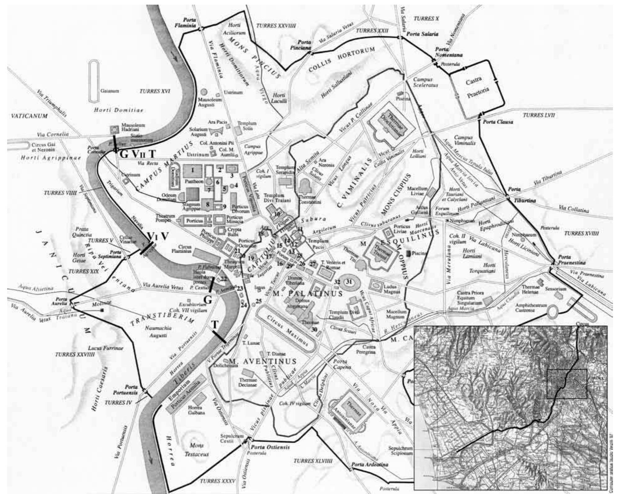
Fig. 1. Plan of the Forum Boarium with the edges of slabs 18 and 27 of the Forma Urbis (adapted from Coarelli 1980, 321).
the second-century b.c. flood defenses instead.7 Emilio Rodríguez-Almeida also noticed that “the
theoretical line of the republican wall in this zone is no more plausible now than it was before.”8
In light of these conflicting views, it seems to me that Coarelli’s Porta Trigemina might be shifted
50 to 100 m along the line of the city walls just before the north slopes of the Aventine hill—anywhere
along the label “Porta Trigemina” in my figure 2, which runs along the line of the city walls—without
compromising his topographical reconstruction of the area of the Forum Boarium (see fig. 3 for
an aerial view of the same area). As for the possible identification—suggested by Coarelli—of the
7
Wiseman 1990. A location of the Porta Trigemina between Pons Sublicius would have stood far from the Pons Aemilius.
the Aventine and the Tiber implies that G. Graccus would have
8
escaped outside of the city toward the southwest, and so the Rodríguez-Almeida 1989.
� 180 Pier Luigi Tucci
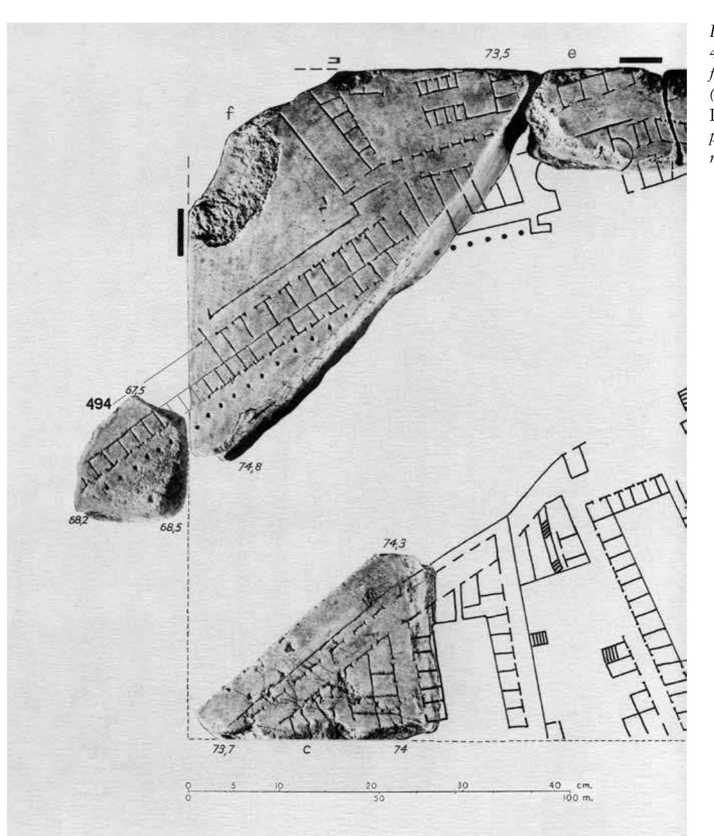
Fig. 2. The Tiber downstream of the Tiber Island with the new fragment 494 joined to slab 27 (adapted from Tucci 2004, fig. 5).
In gray, from left to right, the presumed location of the Pons Sublicius according to Galliazzo, Le Gall, and Coarelli.
The piers attributed to the Pons Sublicius / Theodosii are from G. B. Nolli’s plan of 1748.
Porta Trigemina with the Arcus Lentuli et Crispini of a.d. 2, very likely an Augustan restoration of
a gate still standing in the fifteenth century near S. Maria in Cosmedin (cf. CIL 6.1385), it is worth
noting that Renaissance sources locate this arch either prope or ultra the Church of S. Maria in
Cosmedin, which may be the closest point of reference in the area, and thus closer to the Aventine
hill. In this regard, it is worth noting that Flavio Biondo argued that the arch (and so the original
gate) was located ad primas Aventini radices, confirming that it should be sought in a wider area,
and not necessarily beside S. Maria in Cosmedin.9
A location of the Porta Trigemina closer to the Aventine hill would nevertheless call for a revi-
sion of Coarelli’s identification of the Pons Sublicius. It is worth noting that Coarelli’s proposed
location for the bridge is readily called into question by some fragments of the Forma Urbis showing
the left bank of the Tiber (cf. fig. 2). It appears that Coarelli questioned the existence of the short
stretch of the city wall running from the Aventine to the Tiber mainly because it does not appear
on the Forma Urbis (although the main reason for this seems to be the lack of a corresponding
fragment). If we applied the same criterion to Coarelli’s proposed location of the Pons Sublicius,
9
Biondo 1444, 1:18.
� THE PONS SUBLICIUS: A REINVESTIGATION 181
Fig. 3. Aerial view of the Tiber downstream of the Tiber Island (from Atlante di Roma).
In the box, from left to right, the Tiber Island, the Ponte Rotto, and the Ponte Palatino (photo author).
we would notice that both his street and bridge are not depicted on the Forma Urbis—indeed,
to follow Coarelli’s route, they would have to pass through a wide open space and across a row of
tabernae, respectively. But it is not only the Pons Sublicius that is missing. The network of streets
necessarily associated with it, both on the left and right banks of the Tiber, is also not represented
on the fragments of the Marble Plan (fig. 2).10
A few sources attest that the Pons Sublicius still existed in late antiquity (see below), so its
absence on the Forma Urbis—according to Coarelli’s location—would not be due to a possible
destruction before the Severan age, when the Marble Plan was carved. Unfortunately, none of the
bridges that crossed the Tiber at that time have been securely identified so far on the Forma Urbis,
but the reason for this is easily explained since the relevant fragments are missing. Indeed, there is
no reason to assume that the bridges were not depicted, considering that they were part of the actual
“forma Urbis.” The only evidence might come from one of the already identified fragments, 32a,
which bears the partially preserved inscription in]svla (presumably referring to the Tiber Island) and
10
The same location of the bridge is proposed in Caran- partendo dalle sue testate si era costituito un sistema stradale
dini and Bruno 2008, fig. 2. Colini 1980, 44 claims that the che non poteva esser abbandonato.” This observation is right
Pons Sublicius “è scomparso senza lasciar tracce ma la sua as far as the network of streets is concerned, but the proximity
posizione non poteva esser troppo lontana da quello che lo of the Pons Sublicius to the Pons Aemilius is just a guess.
sostituì dopo la metà del II secolo a.C. (Pons Aemilius) perché
�182 Pier Luigi Tucci
shows the Tiber (as a blank area) and a straight line (fig. 2). In 1960 the editors of Pianta Marmorea
located this fragment in the top left corner of the vertical slab 32, including the Tiber Island and
the Pons Aemilius. This slab was not very accurately reconstructed at the time (the Crypta Balbi,
for instance, appeared in its bottom left corner, next to the Tiber): the straight line would have
corresponded to the left bank of the Tiber, near the horrea beneath the modern Anagrafe.11 This
suggestion was eventually shown to be incompatible with the thickness and veining direction of the
same slab ascertained some years later by Rodríguez-Almeida, who moved fragment 32a near the
other fragments showing the Tiber Island (even though the straight line would have been meaningless
in that position) and placed the fragments 621a–f with the fragmentary inscription aemili toward
the remains of the Pons Aemilius.12
After his 1977 identification of a new group of fragments belonging to the bottom left corner
of the same slab (in his Aggiornamento Generale of 1980), Rodríguez-Almeida decided to “ritoccare
leggermente la posizione” of the other fragments in this slab and presented a new reconstruction,
in which fragment 32a was moved away from the others, rotated, and positioned toward the top
right corner—the straight line corresponding to the Pons Aemilius (as in my fig. 2).13 More recently,
however, contradicting his previous observations, Rodríguez-Almeida located fragment 32a at middle
height along the right edge of the slab—he also rotated it again so that the straight line would be
part of the Pons Cestius—even though this new position conflicts with the veining direction of the
slab and does not take into account the vertical edge of slab 32, as well as the narrow space for the
inscription insvla (which would have appeared after inter dvos pontes and in a scarcely significant
place). At the same time, Rodríguez-Almeida moved to the top right corner of the same slab the
group of fragments with the partially preserved inscription aemili[, which would thus provide the
only evidence for the Pons Aemilius on the Forma Urbis, though their thickness is not compatible
at all with that of the slab.14 Paradoxically, these final adjustments regarding slab 32 would result
in the attestation of two bridges on the Marble Plan (the straight line for the Pons Cestius and the
inscription for the Pons Aemilius). Yet the characteristics of the slab indicate that the right solu-
tion is the one suggested by Rodríguez-Almeida in 1980: fragment 32a must be on top of the slab
(see fig. 2), showing part of the Pons Aemilius and giving the name of the Tiber Island just below
it (perhaps insvla was followed by tiberina or tiberis, which would explain its engraving above
the downstream—upper on the Marble Plan—point of the island).15 More importantly, fragment
32a demonstrates that bridges were actually shown on the Forma Urbis. After all, the place name
inter duos pontes inscribed in the middle of the Tiber Island would have made little sense had the
bridges not been depicted on either side of the island itself.16 In addition, it is worth stressing that the
aqueduct bridges did appear on the Marble Plan, and their arcades were occasionally even depicted
in projection on the ground. Nevertheless, one might argue (as some have) that the Pons Sublicius
11
Pianta Marmorea, 93: “l’iscrizione è incisa su una zona for a possible identification of the Pons Aemilius on fragment
libera da costruzioni (Tevere?) e delimitata in alto da una 625—which I would disallow for reasons of orientation.
linea (sponda?).”
14
See Rodríguez-Almeida 2002, pl. XII.
12
Cf. Rodríguez-Almeida 1970–1971, 109–112; Rodríguez-
Almeida 1995–1996, 374 n. 4 (the inscription would refer 15
The group 621a–f with the inscription aemili[ does not
to the bridge). necessarily belong to slab 32. It might refer to aemiliana
(warehouses)—see Coarelli 1993—or even to the real Porti-
13
See the general plan in Rodríguez-Almeida 1977, fig. 14 cus Aemilia (see below). Cf. Rodríguez-Almeida 1995–1996.
(the Tiber Island is shifted toward the left edge of the slab
and the straight line above the inscription in]svla of fragment 16
See Degrassi 1995.
32a is meaningless); see Rodríguez-Almeida 1981, 115–118
� THE PONS SUBLICIUS: A REINVESTIGATION 183
was just a wooden bridge (which is something I will dispute below), that it was preserved only for
religious and sentimental reasons, and that it was, in the context of the functioning urban fabric,
a “superfluous” element.17 Indeed, one scholar who has argued that the bridge was “superfluous”
has also proposed that it was a “Roman ‘urban myth’ at best,” “a structure whose preservation
became associated with the safety of the Roman state,” and “a symbol of the Roman state.”18 But
even—and especially—if this were the case, there is no reason to presume that this “mythical” but
very real bridge would have been excluded from the Marble Plan.19
All that said, Coarelli’s bridge (fig. 1) might be simply shifted outside of the stretch of the Tiber
covered by the identified fragments and delimited by the dashed lines a and b (fig. 2). But where
should it be? Upstream (closer to the Pons Aemilius) or downstream? It is my opinion that the
former location, which has been suggested (for instance by Le Gall and Galliazzo: see fig. 2), turns
out to be no less problematic than Coarelli’s.
2. The Forma Urbis and the Tiber
When the Pons Sublicius was first built, the area that would eventually become the Forum Boarium
was a marshy one, and the bend of the Tiber at that point was (and remained) dangerously prone
to flooding. No traces of a bridge have ever been identified there—although some ancient wooden
piles belonging to moles and quays elsewhere along the river have in fact been discovered, and in
a remarkable state of preservation.20 Farther downstream, the piers of an ancient bridge were still
visible until the end of the nineteenth century (and, as I highlight below, a late antique source at-
tests that the Pons Sublicius was eventually rebuilt in stone). That said, why is the Pons Sublicius
located so close to the Pons Aemilius in many plans of ancient Rome? The credit (or blame) in
this case must be directed to Joel Le Gall, whose conclusions—published in his 1953 work on the
Tiber—were wholly accepted by Coarelli and Galliazzo.21 Le Gall based his location of the wooden
bridge on the route of Gaius Gracchus’s escape from the Aventine (he would have run “vers le
pont le plus proche”) and on the network of streets on the right bank of the Tiber as reconstructed
by Rodolfo Lanciani in his Forma Urbis Romae—obviously ignoring the ancient streets visible on
fragments 138a–f of the Forma Urbis, identified only in 2004.22 It has already been noticed that Le
Gall’s working bibliography, “far from exhaustive in itself, is essentially that of 1938/1939, when
17
Griffith 2009, 316 and 319. It is at least possible that the Trigemina is rightly considered hypothetical.
wooden bridge was preserved, wholly or in part, as a monu-
20
ment, like the ship of Aeneas described by Procopius, as still Ulrich 2007, 78.
displayed in the mid-sixth century a.d. in a shed built along
21
the Tiber (see Tucci 1997). Le Gall 1953, 80–86 and map II, republished in Le Gall
2005, fig. 42. See Coarelli 1980, 321 and Galliazzo 1994, 2:5
18
Griffith 2009, 318–319. (where the location of the Pons Sublicius is slightly different
than that suggested by Le Gall: cf. my fig. 2). See also Aldrete
19
The location of the Transtibertine bridgehead of the 2007, fig. 1.10; Griffith 2009.
Pons Sublicius is indeed obscure, and slab 27 of the Forma
22
Urbis “neither represents the bridge nor offers a convenient Le Gall 1953, 83–84, who also gives credit to Sextus
street for it to join”: see the entries “Pons Sublicius” and Rufus’s De Regionibus Urbis Romae and his mention of the
“Porta Trigemina” in Dumser 2002, 192–193 and 199–200, “Aedes Portumni ad pontem Sublicium,” even though this
respectively. In this study on Augustan Rome both on the work is not reliable (cf. the Catalog of Publius Victor). Le
Main Map and the Plan of the Central Area, the Pons Gall concludes that the two bridges must have been close to
Sublicius (no. 191) crosses the Tiber precisely in the area each other (p. 85). See Tucci 2004 for the fragments 138a–f
that is covered by the Marble Plan; the location of the Porta of the Forma Urbis.
�184 Pier Luigi Tucci
Fig. 4. Below, the left part
of slab 27 drawn in the late
sixteenth century (BAV,
Vat. Lat. 3439, fol. 20v;
from Pianta Marmorea,
pl. XI). Above, the same
fragment positioned by
Canina 1850 (from Frutaz
1962, 2:pl. 97).
he was beginning his studies in Rome” and “very summarily adjourned up only to 1950,” and that
“this weakness is particularly glaring in his extremely schematic treatment of . . . the site of Rome
and the Sublician bridge.”23
It is also worth noting that Le Gall’s book was published before the 1960 edition of the Marble
Plan, in which Guglielmo Gatti highlighted that “il tratto di fiume rappresentato in questo frammento
[slab 27] corrisponderebbe . . . alla zona in cui, successivamente al tempo della pianta, venne costruito
il Pons Probi” (on this bridge, see below) and also stressed that “non apparirebbe in esso il Ponte
Sublicio che doveva essere situato piu’ a nord, cioè piu’ a sinistra del frammento” (apparently Gatti
was influenced by Le Gall’s plan).24 However Le Gall’s location of the Pons Sublicius is now called
into question by the “new” fragment 494 of the Forma Urbis, the identification of which is presented
23 published in 1960 (in other words, Le Gall’s location of the
Brown 1954.
bridge was not conditioned by the topography depicted on
24 the fragments of the Forma Urbis). In his updated edition
Pianta Marmorea, 86 and n. 3. Le Gall’s location of the
Pons Sublicius was clearly independent from fragment 27f, (Le Gall 2005, 227), Le Gall is aware of the identification
in the top left corner of slab 27, which was identified and of this fragment.
� THE PONS SUBLICIUS: A REINVESTIGATION 185
in this paper for the first time. In Le Gall’s plan the bridgeheads of the Pons Aemilius and of the Pons
Sublicius on the right bank of the Tiber are situated close to each other, and the wooden bridge—
strangely crossing the river at ca. 30°—would have reached the left bank south of the Round Temple by
the Tiber (cf. fig. 2).25 Of course it is likely that Le Gall’s location of the Pons Sublicius was conceived
schematically (as was Galliazzo’s, which simply followed Le Gall’s suggestion), so that the problem
might be solved with a slightly different orientation of the bridge. But there are other issues at stake.
First, it is necessary to review the history of the surviving fragments belonging to slab 27, which
depicts the Tiber banks downstream of the Pons Aemilius. It was only in 1850 that the largest
surviving portion of this slab—discovered in 1562 and eventually classified as fragment 27b—was
identified by Luigi Canina, one of the first scholars to use the Forma Urbis as an archaeological
tool to reconstruct the topography of ancient Rome. Canina realized that the Pons Sublicius was
not depicted on the surviving portion of the slab and consequently located the bridge not near the
Pons Aemilius but farther downstream, just outside of the area covered by the Forma Urbis, in
correspondence with the remains (mentioned above) of the piers of an ancient bridge that were still
visible at the end of the nineteenth century (fig. 4).26 It is worth stressing that the left half of slab 27
was still intact when brought to light in 1562: the Renaissance drawing in BAV, Vat. Lat. 3439 fol.
20v, corresponding to fragment 27b, included both banks of the Tiber (fig. 4, below).27 Sometime
before 1742, the original fragment was broken into pieces, of which the fragments numbered 27a, c,
d, and e now survive, while the blank sector corresponding to the Tiber was cut away and lost. The
“join” between fragment 27f (in the top left-hand corner of slab 27) and the topography depicted
on the Renaissance drawing was noticed by Cozza during the preparation of the 1960 edition of
the Marble Plan: the new fragment shows another sector of the left bank of the Tiber, further con-
firming the absence of the Pons Sublicius.28 In 2004 I was able to identify two fragments (574a–b)
belonging to the bottom right corner of slab 27, together with a group of six fragments (138a–f)
of the next slab, 28. I also suggested—with a question mark on the relevant illustrations—that the
Pons Sublicius might have been located downstream (as in Canina’s plan) not only because it does
not appear on the surviving fragments of the Marble Plan but also because the wide street visible
on my newly identified fragments and corresponding to the Via Campana Portuensis seemed to
point precisely toward those piers visible in the Tiber’s bed until the end of the nineteenth century.29
This very location of the Pons Sublicius had already been suggested by G. B. Falda (1676), G. B.
Nolli (1748), G. Vasi (1754), J. A. Léveil (1847–1870), L. Canina (1850), K. L. Urlichs (1870), C.
D’Onofrio (1980), and possibly others.30
In a recent paper, A. B. Griffith acknowledges my thesis regarding the downstream location
but rejects it in favor of what she describes as a “secure” identification of the bridge and the Porta
25 28
Le Gall 1953, map II; Le Gall 2005, fig. 42. It is worth not- Rodríguez-Almeida suggested that fragment 348 might
ing that in Le Gall’s plan the position of the Ponte Palatino show a short stretch of the left bank of the Tiber just below
is not accurate. the Aventine. It is not clear whether this claim is reliable or
not, but, if true, the identification of this isolated fragment
26
Canina 1850, in Frutaz 1962, 2:pl. 97. Apparently Canina would simply confirm what is already suggested by the to-
made adjustments and corrections in his drawing of the pography on the opposite bank of the Tiber: see Rodríguez-
ancient topography. The piers are clearly visible in Nolli’s Almeida 2002, pl. XII (“ipotesi recenti inedite pendenti di
plan of 1748 as well as in Vasi 1754, pl. 96. A view by verifica,” including the small fragment 568 in slab 32).
Canina—“Veduta dell’antico Ponte Emilio nel suo intero
29
stato”—shows the same situation (but the Pons Sublicius is Tucci 2004. The road in question is the Via Campana Por-
missing): cf. Canina 1851. tuensis: see Coarelli 1992 (not considered by Griffith 2009).
27 30
Pianta Marmorea, pl. XI. Léveil 1870; Urlichs 1870; D’Onofrio 1980 (misunderstood
by Griffith 2009, 309).
�186 Pier Luigi Tucci
Trigemina, probably following Coarelli for the location of the gate and Galliazzo or Le Gall for
the bridge.31 In her rejection of the “downstream” thesis, Griffith argues that (a) the comparative
distance of my proposed location from the seventh- to sixth-century city is difficult to accept; (b) my
interpretation does not take into account the proximity of the northern slope of the Aventine hill to
the gate and the bridge, which is suggested by the accounts of Gracchus’s escape; and (c) that my
suggestion ignores ancient descriptions of the Pons Sublicius, which reiterate that the bridge “was
made only of wood (i.e., not stone piers).”32 However, (a) is little more than an assumption since
both of the alternative locations of the Pons Sublicius would lie outside the city walls and at the
same distance from the Porta Trigemina (which, as I have already argued, might have been anywhere
along the label “Porta Trigemina” in my fig. 2; see also fig. 9).33 Regarding point (b), the proximity
of the north slope of the Aventine hill, the Porta Trigemina, and the Pons Sublicius depends, as
we have seen, on the unknown location of the gate. In fact, as I have argued, the usual location of
the Pons Sublicius next to the Pons Aemilius would be, as suggested by my identification of frag-
ment 494 of the Marble Plan, even more distant from the Aventine than the location I suggested in
my earlier article and I confirm in the present paper. Even assuming that the Porta Trigemina was
situated next to S. Maria in Cosmedin, it would not be clear why the various accounts of Gaius
Gracchus’s escape in 121 b.c. would fit with the traditional location of both the gate and the Pons
Sublicius, and not with a bridge located farther downstream.34 Our sources do not give the exact
distance between the Porta Trigemina and the Pons Sublicius (we are simply told that the bridge
was outside the gate: cf. Val. Max. 4.7.2). As for Griffith’s point (c), I would suggest that the author
has overlooked an important passage by Tacitus, as well as a late fourth-century a.d. reference that
describes the Pons Sublicius as lapideus (built of stone—see below). The reconstruction in stone of
the Pons Sublicius and/or its restoration promoted by the emperor Theodosius (who we may assume
was quite unconcerned with the supposed “sanctity” of the old wooden structure) would suggest
that the piers observed in the Tiber bed at the end of the nineteenth century might have belonged
to a later phase of the wooden bridge. Last but not least, Griffith seems to have misinterpreted the
secondary literature when she claims that “the stone piers of this bridge, blown up in the nineteenth
century, have sometimes been associated with the Pons Probi, but Tucci argues that they belonged to
the Pons Sublicius” (her subsequent footnote 57 reads: “Pons Probi: D’Onofrio 1980:131–140”). 35
In those pages D’Onofrio does not identify the piers with the Pons Probi but with a stone version
of the Pons Sublicius (!)—as had already been suggested by the scholars mentioned above (Falda,
Nolli, Vasi, Léveil, Canina, Urlichs, D’Onofrio). D’Onofrio does not, in fact, locate the Pons Probi
below the Aventine hill but identifies it with the remains of the Neronian bridge near the Vatican.36
31
Griffith 2009, although it is notable that the author does is clearly confusing Gaius with his brother Tiberius. It was
not provide a plan of the Forum Boarium area, and the Gaius who crossed the Tiber on the Pons Sublicius (in 121
evidence provided by the Forma Urbis is not considered. b.c.) and eventually died in the Lucus Furrinae, on the
Also, perhaps significantly, Griffith makes no mention of southern slopes of the Janiculum (Villa Sciarra Wurts)—a site
the reviews of Coarelli 1980 by Wiseman, Ziolkowski, and very close to my downstream location of the Pons Sublicius.
Rodríguez-Almeida.
35
See D’Onofrio 1980, 131–140, and Griffith 2009, 309.
32
The fact that Griffith needs to stress that the bridge “was
36
made only of wood (i.e., not stone piers)” is, if nothing else, D’Onofrio 1980, 131–140 et passim (esp. 89–90 for the
a reflection of the limitations of our sources. Pons Probi near the Vatican). Le Gall 2005, 375–377 makes
the same identification. In the original version of my figure
33
Cf. Ziolkowski 1994. 9 (modified from LTUR 3, fig. 140) the Pons Sublicius was
missing, and the bridge associated with the piers once visible
34
Griffith 2009, 310 connects the Pons Sublicius with “Gaius in the Tiber was identified with the Pons Probi.
Gracchus’ escape from an angry mob in 133 b.c.,” but she
� THE PONS SUBLICIUS: A REINVESTIGATION 187
I do not agree, therefore, with Griffith’s proposal that a bridgehead of the Pons Sublicius in
the Forum Boarium would be “more plausible for the earlier period when the Palatine hill was
the main settlement” because the bridge would have connected the streets meeting at the Porta
Trigemina “with the Via Aurelia on the right bank.”37 In fact the Via Aurelia was built after 241
b.c.38 And, despite Ammerman’s findings, which have revealed that the low-lying area around the
Forum Boarium was regularly flooded (the river embankments erected during Rome’s early history
were considerably farther inland than the current course of the Tiber)39 and might favor a location
of the route of the salt road and of the Pons Sublicius farther downstream, Griffith observes that “if
flooding was a problem,” it would have been possible to extend a pile bridge to a sufficient length.40
Flooding was a real problem in the area of the Forum Boarium. The temples constructed next
to the presumed left bridgehead of the Pons Sublicius were built on very high podia, while under
the street level there was a complicated drainage system, not to mention the embankment wall that
became necessary in the second century b.c.41 The flooding problem was severe enough, in fact, that
we might wonder why the original wooden bridge would have been built so close to this site. After
all, the ancient road that had made it necessary—the salt road—would have turned north (toward
a marsh) just before the proposed location of the bridge, after passing the salinae on the north
slopes of the Aventine hill (cf. Frontin. Aq. 1.5.5: Salinae, imo Clivi Publicii ad Portam Trigeminam,
qui locus Salinae appellatur—see fig. 9). It has already been noticed that in this location the Pons
Sublicius would have been inaccessible in times of high water since the approaches would have
been submerged, which provides “a strong argument” against the placing of the first bridge in the
position commonly assigned to it.42
The Forma Urbis shows that the Tiber was very narrow in the area of the piers that survived
until the end of the nineteenth century (the two banks seem to converge to the bridgeheads), and
it is not unlikely that the first bridge in Rome was built there precisely because it was an easy point
to cross (fig. 2). But, in fact, the bed immediately downstream of the Tiber Island is wider precisely
because of the island (see fig. 3) and, by any measure, it would have been more practical to cross
the river at the island itself (as has also been suggested, although the island was not along the route
leading toward the coast).43 It is also likely that the Pons Sublicius was located farther downstream for
defensive reasons. Griffith acknowledges that, according to our earliest sources—Livy and Dionysius
of Halicarnassus—the bridge was built in the late seventh century b.c. in a period of expansion under
37
Griffith 2009, 309 and 310. river’s surface), and for its construction Apollodorus used
wooden arches set on twenty masonry pillars that spanned
38
On the Via Aurelia, see Patterson 1999 and Coarelli 1996a. 38 m each. The timbers were fastened to one another with
iron pins. Cf. Palladio 1997, 171–181 for the reconstruction
39
See Aldrete 2007, 288 n. 19. of the bridge of Julius Caesar and other projects of wooden
bridges, including his own project at Bassano del Grappa
40
Apparently Griffith was so concerned with the technologi- (book 3, chaps. 5–9). A pair of temporary wooden bridges
cal aspects of the Pons Sublicius as to forget that the closest were also built in nineteenth-century Rome.
comparanda would be the wooden bridges built during
41
the course of military campaigns. A good example is Julius I would also recall the viaduct of the Via Aurelia on the
Caesar’s bridge over the Rhine, built in just ten days in 55 opposite bank of the Tiber: see Gatti 1940, 137 (“la strada
b.c., where the use of metal fasteners cannot be excluded. che esso sosteneva non si dirigeva esattamente al ponte
It is also worth mentioning Apollodorus of Damascus’s Emilio, ma poco più a valle di esso. Non ritengo possibile,
stone and wood bridge over the Danube, built around a.d. però, che a tanta breve distanza potesse essere il vetusto
103–105, which is represented on Trajan’s Column (a.d. Ponte Sublicio”).
113) and described by Cassius Dio (68.13.1, although this
42
author never actually saw it). See Ulrich 2007, 80–83 and Holland 1961, 162 and n. 86.
104–107. The Danube bridge was 1,135 m in length, 15 m
43
in width, and reached 19 m in height (measured from the See Holland 1961.
�188 Pier Luigi Tucci
Ancus Marcius, who “fortified the Janiculum hill against enemy capture, and connected it to the city
by means of a pile bridge,” and also created “the first fossa along Rome’s most notorious weak spot
on the east side of the city.” Griffith also observes that “both authors represent the construction
of the bridge as practical and strategic.” A bridge below the Aventine hill would have been easily
defensible and, in addition, its wooden piles would have blocked the way to the enemy ships, which
would not have been able to reach the Forum Boarium and the Portus Tiberinus. In contrast, in its
traditionally proposed location next to the (later) Pons Aemilius, the bridge would have facilitated
the arrival of enemies right in front of the city walls. Griffith, dismissing the identification of the
“wooden” Pons Sublicius with the stone piers once visible in the Tiber, proposes that the bridge
crossed the river between the outlet of the Cloaca Maxima and the mouth of the Circus Maximus
brook.44 This area is mentioned by literary sources (see below on the place name inter duos pontes)
and was also excavated with no positive results in the last century. More importantly, this very area
is partially depicted on the fragment 494 of the Forma Urbis (fig. 2).
3. The New Fragment 494
Since the left portion of slab 27 was almost intact when discovered in 1562—it was divided into the
top left corner (fragment 27f) and the big fragment 27b—it is not unlikely that one or more pieces
belonging to slab 18 (on its left) might have survived as well, among the hundreds of fragments
with unidentified topography of the Forma Urbis. With this in mind, I searched for a possible con-
tinuation of the riverfront on the left bank of the Tiber toward the Pons Aemilius, as depicted on
fragment 27f (cf. fig. 5), in the hope of finding some trace that could have provided evidence, pro or
con, for the existence of the Pons Sublicius in that area. A fragment of this kind would, presumably,
show a row of columns running before a line of tabernae, with a continuous back wall and with an
empty space behind, inclined at ca. 45° with the slab edge. In a certain sense, my method followed
the procedure established by the Stanford University Digital Forma Urbis Romae team, known as
the automated boundary incision matching technique: once the incised features that extend off the
boundaries of each fragment are annotated—indicating their position, directions, and features types
(such as rows of columns and tabernae fronts), the boundary incision matching algorithm searches
through the corpus of annotated fragments, considering each possible pairing and examining every
reasonable alignment of the annotated features. Fragment pairings with exceptionally high scores
are flagged “for further review by an archaeological expert.”45 I followed the same procedure but
in a more “traditional” way—I simply examined the fragments published in the plates of Pianta
Marmorea—and since the range of thickness, marble veining, and back surface of slab 18 were
44
Griffith 2009, 308 adds, “and between the Porta Flumen- 2004. In addition, Galliazzo’s location of the bridge does not
tana and Porta Trigemina,” but given the absence of a plan, take into consideration the toponym inter duos pontes (see
it is not clear if she is referring to another stretch of the Tiber below). Galliazzo 1994 (2:25–26) begins his entry on the Pons
bank. In fact, it is not entirely clear whether she agrees with Sublicius by claiming that this bridge “si trovava in un sito
Coarelli’s location of the Pons Sublicius (cf. my figs. 1–2) or ancora incerto,” but he goes on to state that it was “senz’altro
with the location suggested by Galliazzo 1994, 2:5 (where immediatamente a valle del ponte Emilio . . . presso il Foro
the Pons Sublicius, n. 9, is situated very close to the Pons Boario e il tempio di Portuno: comunque era sicuramente a
Aemilius). It is worth noting that on Galliazzo’s plan the monte del corno nord-occidentale dell’Aventino e della Porta
Circus Flaminius is still situated in the area of the Theatrum Trigemina,” without further explanation. It seems likely that
and Crypta Balbi—a pre-1960 location—and, more impor- in this case he was influenced by Le Gall. It is also worth
tantly, the route of the Via Campana Portuensis converges noting that Galliazzo was unaware of D’Onofrio 1980.
toward the two bridges but does not correspond to the
45
actual topography depicted on the Forma Urbis—see Tucci Koller and Levoy 2006.
� THE PONS SUBLICIUS: A REINVESTIGATION 189
Fig. 5. Fragment
494 joined to
fragment 27f
(adapted from
Pianta Marmorea,
pls. LI and XIX
respectively).
unknown, I had to examine each of the hundreds of fragments with unidentified topography. After
a few minutes, however, I noticed that fragment 494, included in plate LI of the 1960 edition of the
Marble Plan, matched the topography depicted on fragment 27f (fig. 5).46
Fragment 494 belongs to one of the horizontal slabs in the sixth row from the bottom of the
Marble Plan (fig. 6). This slab covered the area between the Roman Forum and the Forum Boarium,
including the Velabrum and the underground route of the Cloaca Maxima. The Round Temple by
the Tiber and the Temple of Portunus would have appeared on the right side of this slab (see fig.
2), as well as the southeast corner of the complex at Sant’Omobono. The few surviving fragments
of the left side of the same slab show the Basilica Julia and—only partially—the Temple of Castor
and Pollux and the Temple of Saturn (fragments 18b–d). It is also likely that fragment 18e depicted
the partial plan of the Temple of the Deified Augustus and the area of the so-called Grecostasis.
46 would have been apparent that the colonnade could not turn
It is not clear whether the Stanford team’s manual input is
at fault here or whether the algorithm somehow failed in this inside the Tiber bed. Fragments 574a–b and 534a–b, which
case. The last column on fragment 27f might suggest a change I identified following the same “traditional” procedure, also
of direction of the row of columns, but, seen in context, it escaped Stanford’s algorithm (cf. Tucci 2004; Tucci 2006).
� 190 Pier Luigi Tucci
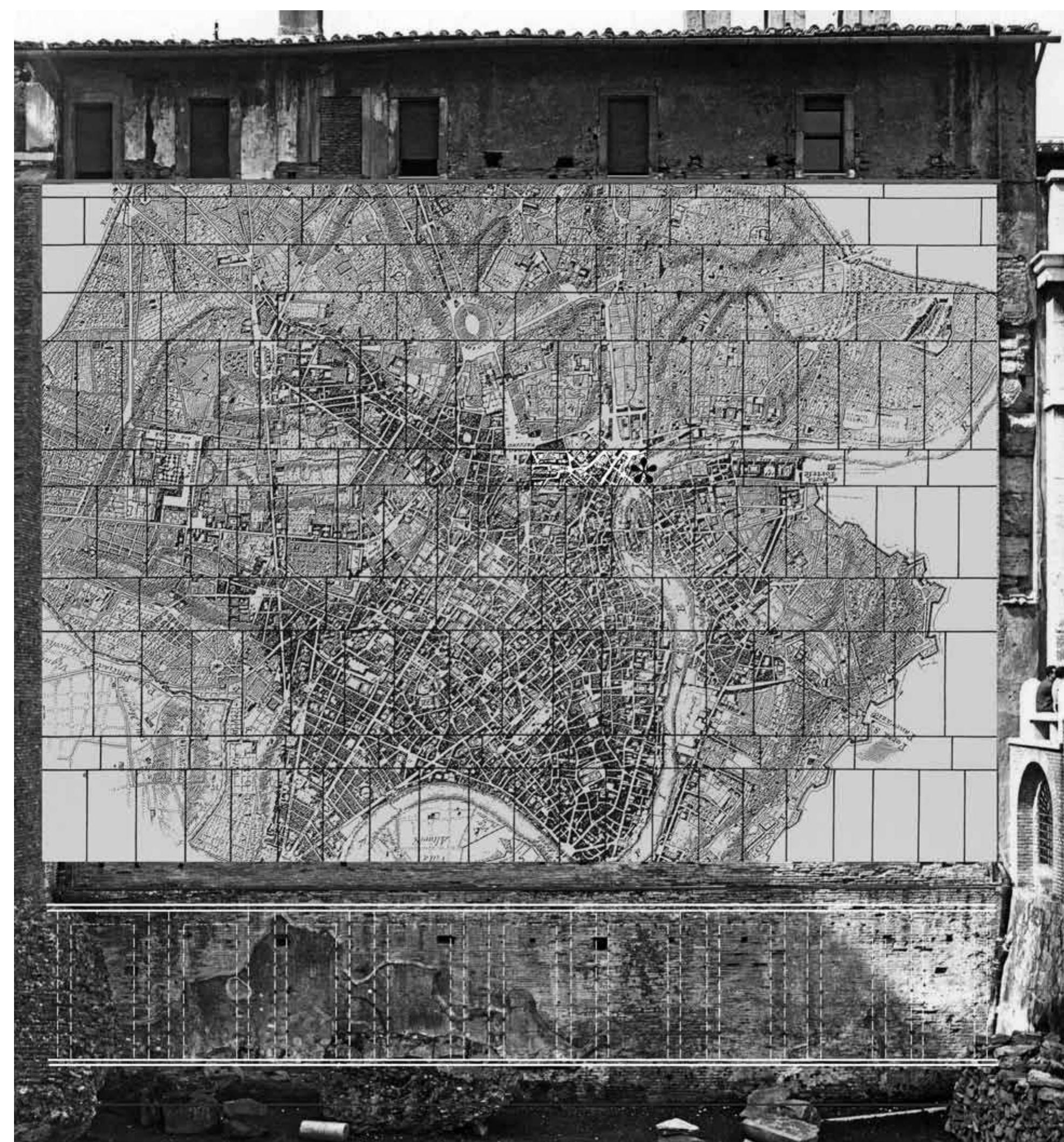
Fig. 6. Fragment 494 (asterisk) in the Severan Forma Urbis (photo and drawing author; the base is G. B. Nolli’s plan of Rome).
These fragments are known, however, thanks to late sixteenth-century drawings, with the excep-
tion of fragment 18c, which is still preserved, though its back surface was sawn off, leaving a thin
slab, or “lastrina.” This is why the back surface of slab 18 has not been documented so far and why
Rodríguez-Almeida described it as originally “rough”—he thought that fragment 18c had been
sawn off to eliminate the irregularities of the back surface, whereas it is now clear that this was
� THE PONS SUBLICIUS: A REINVESTIGATION 191
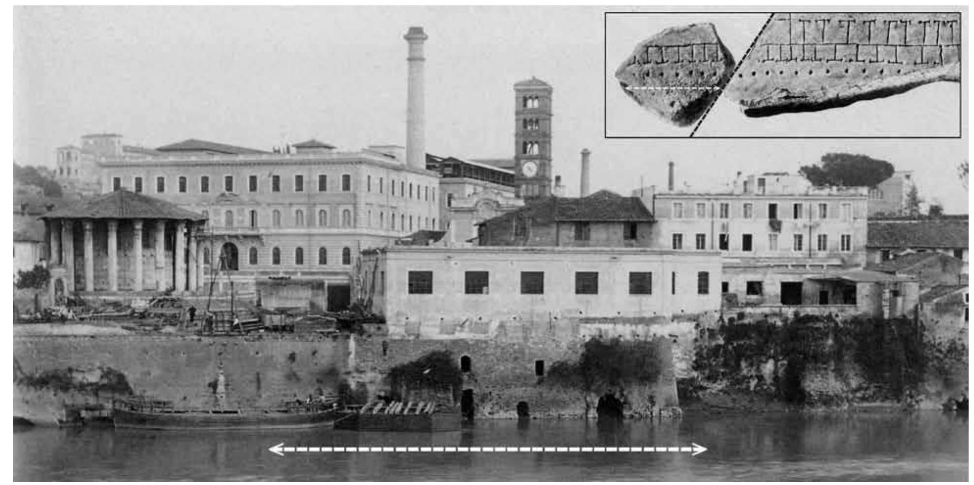
Fig. 7. Stretch of the left bank of the Tiber, with the indication of the riverfront corresponding to the portico
depicted on fragment 494; in the box, fragment 494 joined to fragment 27f—a detail of fig. 5 (adapted from Brizzi 1989, 191).
done only to reduce its thickness.47 Fragment 494 makes it clear (for the very first time) that the
back surface of the whole slab 18 was originally smooth, with a thickness of around 67.5–68.5 mm.
Unfortunately the marble veining is not ascertainable since the fragment itself is too small and its
surface is corroded by fire.48
The topography depicted on fragment 494 extends the “no-bridge zone” toward the Pons
Aemilius. The Pons Sublicius does not appear on the new stretch of the left bank of the Tiber (fig.
2), which renders Le Gall’s plan obsolete. The new fragment shows the continuation of the colon-
naded portico, which is depicted on fragment 27f and was apparently at least 100 m long (fig. 7).
The possible location of a bridge across the Tiber and orthogonal to the two banks had already
been excluded by the topography depicted on fragment 27c, but the newly identified fragment 494
makes it possible to rule out potential locations of the Pons Sublicius at ca. 30° across the river (as
Le Gall has already proposed, without explanation).49 The presumed alignment between Coarelli’s
Porta Trigemina and the bridge must, therefore, be ruled incorrect, and the left bridgehead should
be moved farther away from the gate.
47 has been explained by the workers cutting or breaking off
Rodríguez-Almeida 1981, 98 writes that “la lastra del n. 18
è indicata (dubitativamente) come a rovescio grezzo per via the parts of slabs that projected into the circumference of
del sospetto che nasce dal vedere il frammento 18c ridotto the hole. The reason why none of the fragments from within
a lastrina.” See Rodríguez-Almeida 1992, fig. 17. that area had been identified was explained by the assump-
tion that they were incorporated into the repaired wall.
48 But fragment 494, found in 1562, belongs precisely to this
Fragment 494 is also important in relation to the destruc-
tion of the Marble Plan as a whole. The circular patch of area (together with the now lost fragment 18e). Both pieces
brick facing in the middle of the Severan wall is the medieval were also corroded by fire. See Tucci 2007 for the relevant
fill of an actual hole pierced in the Middle Ages, as I have bibliography (and my forthcoming book on the Templum
recently ascertained inside the Monastery of SS. Cosma e Pacis for further details).
Damiano. No fragments of the Plan had been previously
identified within the outline of this circular lacuna. The 49
We may assume that the bridge must have been upstream of
survival of many small fragments from the edge of this area the dashed line a or downstream of the dashed line b (fig. 2).
�192 Pier Luigi Tucci
It is worth noting, also by comparison with the portico on the opposite bank of the Tiber (frag-
ment 27c, in the bottom left corner of the slab), that on fragment 494 the columns of the portico
are rendered with dots and not dashes, which suggests that the portico was made of columns rather
than piers. On fragment 27f, toward the slab edge, it is also possible to notice a difference in the
relation between columns and tabernae. Indeed most of the columns visible on fragment 27f do not
correspond exactly to the partition walls of the tabernae. A transversal line marks the end of these
tabernae (the rear side of which is in common with a row of larger tabernae opening onto an open
space) and the beginning of a single row of tabernae with a blank space behind them, which contin-
ues quite precisely on fragment 494. In this row of tabernae there is a more regular correspondence
between columns and partition walls; the straight line at the edge of fragment 27f instead cannot be
seen on fragment 494 because its surface is not preserved up to that limit.50 On fragment 494 it is
possible to identify eight tabernae (only five completely preserved) and six columns, which are not
perfectly aligned and spaced.51 Unfortunately, I could not see the actual fragment because in the
last ten years the Forma Urbis has been kept in wooden crates and, apparently, only a privileged
few have had the opportunity to see it. The detailed photographs of the 1960 edition allowed me
to verify the alignment of the tabernae and portico on fragments 494 and 27f (and to fill the gap
corresponding to the edge, as in fig. 5). With the actual fragments at my disposal, I would examine
the ductus of the carver and the traces of the sawn marks on the back surface, which (if preserved)
should be perpendicular to the edge of the slab (slab 18 was a horizontal rectangular slab, and in
such cases the sawn marks are parallel to the long sides and perpendicular to the short ones).
It is likely, considering other fragments of the Forma Urbis, and especially those depicting the
Tiber banks, that this row of columns marked the edge of a portico—which would have delimited
the ancient street corresponding to the present Lungotevere Aventino—at a certain height above
the Tiber water level, although it is possible (by comparison with the Marble Plan from Via Anicia)
that the actual riverside was not carved. It is not clear whether the Republican embankment was
still the limit of the left bank of the Tiber in the Severan age, when the Forma Urbis was carved, or
if the topography depicted on fragments 494 and 27f records a partial occupation of the river bed.
We know that Trajan reorganized the whole of the Tiber banks, which resulted in larger and more
sophisticated dock facilities (as attested, for instance, by the horrea on the former site of the Portus
Tiberinus or in the area of Testaccio).52 Otherwise one might consider the usual distortions of the
Marble Plan that require shiftings and adjustments to make any plausible relation to the actual layout
make sense. But, since the left part of slab 27 can be reconstructed in its entirety, it is apparent that
on the Marble Plan the Tiber was narrower than in the Augustan age and today.53 In any case, it is
50 52
In his updated edition Le Gall suggests that, in light of the A curator alvei et riparum Tiberis et cloacarum urbis (curator
noncorrespondence with the walls of the tabernae, the dots of the channel and banks of the Tiber and the sewers of the
visible on fragment 27f (as well as on fragment 494) might city) was appointed from a.d. 100.
represent bollards for small boats (lintres): see Le Gall 2005,
53
227. It seems to me, however, that it is unlikely that such ele- Dionysius of Halicarnassus (Ant. Rom. 9.68.2) states that
ments were depicted on the Marble Plan: the Forma Urbis is the breadth of the Tiber was ca. 120 m (at the end of the
simply not very accurate, as can be seen in the plans of other first century b.c.); on slab 27 of the Severan Forma Urbis
porticoes (cf. fragment 20c). it is ca. 65 m and probably even less (indeed the actual
banks are missing). If the topography depicted on the
51
What is lost, because of the fractures along the edges of the Marble Plan were to be shifted backward on both banks,
two adjoining slabs 18 and 27, are one column (toward the the row of columns on the left bank of the Tiber would
edge of fragment 494) and three partition walls of the tabernae. correspond to the line of the late Republican embankment,
It is worth noting that the last dot on fragment 27f is not well and the blank space behind the tabernae would be next to
rendered in the photograph of the 1960 edition of the Marble the Round Temple, suggesting the existence of a sort of
Plan and so does not seem to align with the next columns. temenos—the tabernae would be missing on the rear side
� THE PONS SUBLICIUS: A REINVESTIGATION 193
worth considering that slab 27 is not complete and that its left edge corresponds to a sector of the
wall of the hall in the Templum Pacis in which the Severan brick facing is missing. Consequently
the length of the slab cannot be determined, and its left portion together with the new fragment
494 might be placed farther to the left, closer to the Pons Aemilius (note that the entrance to the
taberna on the left of fragment 494 suggests a change of direction, directly toward the bridgehead
of the Pons Aemilius).54 If so, only a very narrow space would be available for a possible location
of the Pons Sublicius in that area.
Fragment 494 covers the stretch of the left bank of the Tiber characterized (from north to south)
by the Cloaca Maxima (CM in fig. 2), the so-called Cloaca Mediana (which would correspond to the
area depicted on fragment 494), and the sewer of the Circus Maximus (see fig. 2)—all attesting to
the fact that in ancient times the site of the Forum Boarium required a complex drainage system.55
Archaeological investigations carried out in the 1970s demonstrated that the Round Temple had
been raised on an artificial platform that was laid out in the early second century b.c. and connected
to the river’s embankment. These works are credited by Coarelli to the censors of 179 b.c., M. Ae-
milius Lepidus and M. Fulvius Nobilior, who undertook a general refurbishing and standardization
of the riverside quays, while their completion should be credited to the censors of 142 b.c. (cf. Livy
40.51)—which is the conventional terminus post quem for the construction of the Round Temple.56
As noticed by H. Bauer, the outlet of the Cloaca Maxima into the Tiber, which is constituted by
a triple arch of Lapis Gabinus inserted into a wall of Grotta Oscura, might date to the second or
even to the first century b.c. and has nothing to do with its original phase.57
The 200 m–long embankment wall provided security for one of the city’s most sensitive zones
of exposure to the floodwaters of the Tiber. For here, at the river’s main curve through Rome, its
currents and floods hit the left bank at a destructively sharp angle—not a favorable location for
a bridge, especially one made of wood. The same wall must have played an important role in the
defensive line along the Tiber. Indeed, a broad strip of land, some 50–80 m wide, separated the
embankment wall from the Forum Boarium. Thus the fortifications had to be close enough to the
riverside to prevent an enemy from using the bank as an easy platform for attack.58 Also within the
area was the precinct of the Temple of Portunus, the earliest phase of which dates to the late fourth
century b.c. This structure was raised on a podium 6 m tall and fronted by an arched passageway
erected against the continuous problem of floods.59 Considering the presence of the artificial harbor
of the Portus Tiberinus just north of the presumed left bridgehead of the Pons Sublicius, the high
platforms of the two temples between the walls and the river, and the network of draining sewers,
it is unlikely that the original wooden bridge was built in this area—or that the ancient salt road
existing even before the bridge would have crossed the river at this point. It is not coincidental
that Rome’s first stone bridge, the Pons Aemilius, was begun only in 179 b.c. (with the piers: Livy
55
for this very reason. In any case, it is interesting to notice For the network of ancient sewers, see Visconti 1892,
the apparent presence of wide empty spaces in the Forum 261–263.
Boarium area (see below).
56
Rakob and Heilmeyer 1973; cf. Coarelli 1978.
54
My figure 2 shows that the topography on the right bank
57
of the Tiber is just 10 m beyond the pre-Lungotevere bank, Bauer 1993.
whereas on the left bank it is between 30 and 40 m inside
58
the Tiber bed. In order to have a more reliable situation, Indeed the wooden spans that linked the piers of Trajan’s
the vertical edge (and consequently the fragments) should bridge over the Danube were dismantled because Hadrian—
be moved toward the left. The situation would not change so Dio tells us (68.13.1)—was afraid that the bridge itself
for Coarelli’s location of the Pons Sublicius but would get could be used for enemy counterattacks.
worse for Le Gall’s.
59
Ruggiero 1992.
�194 Pier Luigi Tucci
40.51.4). It was completed (with the construction of its arches) in 142 b.c. as part of the general
reorganization of the river frontage.60
Now that it is clear that Coarelli’s and Le Gall’s proposed locations are not compatible with the
Forma Urbis (cf. fig. 2), we might simply shift the Pons Sublicius a bit farther upstream. However,
since the Cloaca Maxima was built after the bridge, and the archaeological and literary evidence
suggests that in the sixth century b.c. at least the final stretch of the Cloaca was still an open-air canal,
this location seems unlikely because the great drain would have discharged its sewage directly on the
wooden piles of the sacred bridge! The other location suggested by Galliazzo (who in fact simply
wished to follow Le Gall’s location of the bridge), with the left bridgehead immediately upstream
of the outlet of the Cloaca Maxima, is no more compelling: indeed the area between the Cloaca
Maxima and the Pons Aemilius was investigated between 1886 and 1891 during the construction
of the piers of the Ponte Palatino and of the Tiber quay (cf. fig. 3), and no traces of wooden piles
or stone piers were found during this work.61
All this said, and, as noted previously, I believe that the Pons Sublicius must have been located far
downstream of the outlet of the Cloaca Maxima, in order to take into account not only the informa-
tion provided by the Forma Urbis but also the literary sources concerning the area “between the two
bridges.” The inscription inter dvos pontes, which appears on fragments 32b–e of the Severan Forma
Urbis, clearly refers to the Tiber Island—“between the two bridges” would be the area between the
Pons Fabricius and the Pons Cestius.62 Literary sources attest that the pisces lupi (sea bass) could be
fished inter duos pontes, which of course cannot mean on the area of the Tiber Island between the two
bridges (modern Piazza San Bartolomeo all’Isola) corresponding to the inscription of the Forma Urbis.
Thus it would seem the same place name could have referred to a nearby area as well. According to
some previous explanations, “between the two bridges” might have meant “round” or “around the
island,” or, more likely, the stretch of the Tiber between the Pons Aemilius and the Pons Sublicius.63
If the latter explanation is right, it is not clear why we should imagine the two bridges standing next
to each other (cf. fig. 2), a supposition implied by Taylor’s “narrow space” or by Coarelli’s “tratto di
fiume immediatamente a valle del Pons Aemilius.”64 Horace, who is one of our sources, simply asks
(Serm. 2.2.31): “From what evidence can you tell whether this gaping bass here was caught in the
Tiber or in the open sea, whether it was tossed about between the bridges (pontesne inter iactatus) or
just inside the Etruscan river’s mouth?” In this case, inter pontes might imply any part of the Tiber
inside the city of Rome proper, and not necessarily a place between two bridges. It is worth noting that
Horace, who provides the earliest testimony for this place name, may have employed an expression
that arose in the late Republic, when the Pons Sublicius and the Pons Aemilius (179–142 b.c.) were
the only two bridges crossing the Tiber in the heart of the city (otherwise it would not be clear why
any other stretch of the Tiber extending between two bridges should be excluded).
60
Coarelli 1996a, who has suggested an original third-century quinius Superbus . . . was beaten to death with a club by the
phase of the bridge dating to 241 b.c. Roman people between two bridges (inter duos pontes) and
buried in the Circus Maximus under the dolphins.”
61
Ulrich 2007, 78. See also Donini 1959, 47–48 for the
remains of wooden elements of a bridge in Sardinia, as 63
See Courtney 1980, 242–244 (“round the island”).
well as Giampaola and Carsana 2010 for the hundreds of
wooden posts found in situ during the recent excavation of 64
Taylor 2002; Coarelli 1996b (although his citation of Mac-
the Graeco-Roman harbor at Naples. robius is erroneous—it is not Saturnalia 2.12 but 3.16.11–18.
Juvenal, Sat. 5.103–106, also mentioned by Coarelli, describes
62
Plutarch (Public. 8.3) reports that the Tiber Island “is called an ugly fish “who knows his way right into the drain under
in the Latin tongue inter duos pontes.” The Chronography of the middle of the Subura,” but it is Coarelli who adds that
a.d. 354, part 16 (Chronicle of the City of Rome), in MGH, the outlet of the Cloaca Maxima was located “between the
Chronica Minora, vol. 1 (1892) 143–148—recalls that “Tar- two bridges.”
� THE PONS SUBLICIUS: A REINVESTIGATION 195
Pliny the Elder (HN 9.169) clearly refers to two bridges when he states that “the same kinds of
fish are of better quality in different places, for example the sea bass in the Tiber between the two
bridges (inter duos pontes).” Macrobius (Sat. 3.16.11–18) quotes a passage on the good quality of
the Tiber’s lupus from the eleventh book of Marcus Varro’s Antiquities of Men; here we read that
“Varro is certainly speaking of all fish caught in the Tiber, but of these fish, as I have already said,
the pike held the first place, and in particular pike caught between the two bridges (inter duos pon-
tes).” Macrobius goes on to quote Gaius Tatius, describing some drunken men on their way to the
Forum to act as judges, suggesting they should eat “a genuine pike caught between the two bridges.”
Macrobius also cites some lines from the poet Lucilius, describing “a scavenger fish from the Tiber,
caught between the two bridges.” Macrobius explains that Lucilius was apparently familiar with
this kind of fish, which had a remarkably good flavor, acquired from its scavenger’s diet of excre-
ment and other leavings that fell or streamed into the river at this location. But nothing in these
sources clearly describes the relative proximity of these two bridges or the sewers that provided the
scavenger fishes’ diet. Looking again at my plan of the area (fig. 2), it is apparent that my proposed
downstream location for the Pons Sublicius would include in the area inter duos pontes the mouth
of the Cloaca Maxima and the outlet of two more sewers as well.65 This contrasts with Galliazzo’s
location of the Pons Sublicius, where the banks between the two bridges would correspond to an
area less than 30 m long, and with no sewers at all. A position slightly downstream, between Gal-
liazzo’s and Le Gall’s bridges, would just include a few meters of the left bank downstream of the
mouth of the Cloaca Maxima yet too close to it—and so I would exclude this possibility.
As for the right bank of the Tiber, in Le Gall’s and Galliazzo’s proposals there would be two
bridges (the Sublicius and Aemilius) and two roads converging on the same spot. But if this were
so, we have to wonder why the Pons Aemilius would have been built here (in 179 b.c. according to
literary sources), so close to the already standing Sublicius, with both bridges crossing the river at
almost the same point, in a very cramped and narrow location. We might also ask why, under these
circumstances, the Pons Sublicius would have been linked to the Via Aurelia, which was built no
earlier than 241 b.c.66 Since the Pons Sublicius should, by all accounts, be connected to the Via
Campana Portuensis, it is worth recalling that prior to my identification of the Transtiberim frag-
ments in 2004, the ancient street corresponding to the Via dei Vascellari/Via di S. Cecilia/Via di S.
Michele (cf. fig. 2) was wrongly connected to the Via Campana Portuensis, which appears on slab
28 of the Marble Plan. We now know that there were two distinct streets (depicted on the fragments
138a–f), the narrower of which terminated in a dead end just outside the modern Porta Portese.
The second, wider one ran toward the four piers of the bridge demolished in 1877–1878.67 The
hypothetical continuation of this street toward the presumed bridgehead on the right bank, next to
65
R. Taylor has observed that “Renaissance tradition [in [why narrow?] space called inter duos pontes.” Cf. Taylor
fact also post-Renaissance scholars] erroneously placed the 2002, 3 and map I.
Pons Sublicius squarely west of the Aventine, at the site of
66
the ruins of a row of ancient piers. But these piers could See Patterson 1999. I have already noted that according
not have belonged to the Pons Sublicius—not only because to Colini 1980, 44 the location of the Pons Sublicius “non
of the latter’s wooden pilings” (but see the late antique poteva esser troppo lontana da quello che lo sostituì dopo
source I mention below). He goes on to say that “the story la metà del II secolo a.C. (Pons Aemilius) perché partendo
of Horatius Cocles’ defense of the Pons Sublicius indicates dalle sue testate si era costituito un sistema stradale che non
that the bridge led directly to the old city circuit known as poteva esser abbandonato.”
the Servian Wall [this is true in any case], which did not
67
include the Aventine Hill” and that the literary evidence also This could not be the Pons Probi, which was built in a.d.
suggests that the mouth of the Cloaca Maxima lay between 276–282, long after the Severan Marble Plan was carved
the Pons Aemilius and the Pons Sublicius “in the narrow (see below).
�196 Pier Luigi Tucci
the Pons Aemilius, is not supported by the topography depicted on slab 27 of the Marble Plan. In my
2004 paper I have already shown, on the basis of many modern plans of Rome, that the main, wider
street declined in importance and disappeared during the Middle Ages, long before the construction
of the Ospizio Apostolico di San Michele obliterated it toward the end of the seventeenth century.
The probable reason was the final collapse of the Pons Sublicius (in my downstream location) in the
early Middle Ages, after which the sources do not mention it anymore.68 I would further argue, now,
that this ancient, wider street would most likely have survived if it had in fact connected with the Pons
Aemilius. Instead, it became the first and only case of an important ancient street that disappeared
entirely during the Middle Ages. Finally, we should mention the problem of the Temple of Fors
Fortuna, which was built at the first milestone of the Via Campana-Portuensis. It is not clear whether
the starting point of this road was at the Porta Trigemina or at the Pons Sublicius itself, but in either
case it is possible to verify that, starting from their usual locations, the Marble Plan does not show
any temple at the first mile (ca. 1,478.9 m), while my proposed downstream location of the bridge
would push the temple beyond of the edge of slab 28, to the adjoining (but unfortunately lost) slab.69
4. The Porticoes extra Portam Trigeminam
Before considering other written sources on the Pons Sublicius, it is to the portico depicted on frag-
ments 494 and 27f that I will turn once again. Indeed the usual location of the Pons Sublicius might
also be in contrast to that of the Republican ship sheds (navalia) in the Campus Martius. Cozza and
I have recently identified the navalia with the building in opus incertum commonly known as the
Porticus Aemilia, which is still standing on the left bank of the Tiber, southwest of the Aventine hill
(modern Testaccio). The location of the real Porticus Aemilia near the Forum Boarium, between the
Porta Trigemina and the Tiber, is obviously consistent with our identification of the navalia.
Livy tells us that in the first decades of the second century b.c. a series of porticoes were built
in close succession outside the Porta Trigemina:
193 b.c.: “The aedilship of Marcus Aemilius Lepidus and Lucius Aemilius Paulus was notable
that year; they . . . constructed (perduxerunt) one portico (porticus una) outside the Porta Tri-
gemina, adding a wharf (emporium) on the Tiber” (Livy 35.10.11–12);
192 b.c.: “the curule aediles Marcus Tuccius and Publius Junius Brutus . . . built a portico (por-
ticus) outside the Porta Trigemina in the wood dealers’ quarter” (Livy 35.41.10);
179 b.c.: “Marcus Fulvius contracted for additional works and of greater utility: a harbor (portum)
and the piles of a bridge over the Tiber . . . also a portico (porticus) outside the Porta Trigemina,
and another behind the dockyards,” etc. (Livy 40.51.4–6);70
174 b.c.: “The censors who were elected that year, Quintus Fulvius Flaccus and Aulus Postumius
Albinus . . . outside the Porta Trigemina they paved the warehouse (emporium) with stone and
enclosed it with paling, and they contracted for repairs to the portico of Aemilius (porticus Ae-
milia), and built a stairway from the Tiber to the warehouse (emporium). And within the same
gate they paved with flint the portico (porticus) leading to the Aventine” (Livy 41.27.1 and 8–9).71
68 70
Tucci 2004, figs. 4–6. Indeed, it was the street correspond- Coarelli refers this passage to the construction of the
ing to Via dei Vascellari /Via di S. Cecilia /Via di S. Michele embankment wall but, as the new fragment 494 shows, at
that gained priority and survived, which might explain the least in the Severan age the embankment was surmounted
choice of location for the Church of S. Cecilia in Trastevere. by a porticus.
See Goodson 2010, 103, who relies on the usual location of
71
the Pons Sublicius. Outside Rome, Fulvius Flaccus alone contracted for “a fo-
rum, to be enclosed by porticoes and shops” (Livy 41.27.12).
69
Coarelli 1992.
� THE PONS SUBLICIUS: A REINVESTIGATION 197
Wherever the Republican gate may have stood, the long portico along the Tiber that is depicted
on fragments 494 and 27f was clearly located extra Portam Trigeminam. According to Coarelli, that
place name would not refer to the area immediately outside of the gate, but, as a matter of fact, he
locates the Columna Minucia, which stood extra Portam Trigeminam (Plin. HN 34.21; cf. Livy 4.16),
precisely next to the gate and the Forum Boarium.72 Thus it is likely that the porticoes mentioned
above—the Porticus Aemilia included—were located in the same area. Since the publication of
a paper by Gatti in 1936, however, the Porticus Aemilia has been commonly identified with the
building in opus incertum still visible in the area of Testaccio and depicted on fragments 23 and
24b–c of the Forma Urbis.73 Coarelli claimed that its location at a considerable distance from the
gate would not be surprising since the area southwest of the Aventine could be indicated only with
the place name extra Portam Trigeminam for lack of other landmarks.74 But, if so, why would the
Porticus Aemilia have stood ca. 500 m from the gate, and the Pons Sublicius, which was outside
the Portam Trigeminam as implied by the story of Gaius Gracchus, right in front of the gate itself?
Another aspect generally taken for granted is that the emporium of 193 and 174 b.c. mentioned
above would have stood right before the Porticus Aemilia: in fact this location is simply the result
of the usual identification of that porticus with the building at Testaccio. It is not even clear why the
porticus restored in 174 b.c. should stand out from all the other porticoes built in the early second
century b.c. (also perplexing is a restoration of the original building after less than twenty years).75
As a whole, those porticoes (including the other Porticus Aemilia erected in 193 b.c. north of the
Capitoline arx, “from the Porta Fontinalis to the altar of Mars, where the way led into the Campus
Martius”—Livy 35.10.12) did not leave any traces, unlike the building at Testaccio. It is likely that
the real Porticus Aemilia was nothing more than a porticoed road outside the Porta Trigemina. Not
by chance, the other porticus built in the same year (174 b.c.) as the Porticus Aemilia and running
along the Clivus Capitolinus (Livy 41.27.7) can only have been a short and narrow via tecta since
lack of space would not have allowed for any development to either side. Apparently in the early
second century b.c. some of the main streets of Rome had column-supported roofs, and most of
these were doomed soon to be swept away.76
Gatti’s identification of the Porticus Aemilia with the building at Testaccio (and of the empo-
rium in front of it) has already been questioned for a variety of reasons. As stressed by Richardson
in 1976, its building technique seems too sophisticated for the early second century b.c., and its
plan and elevation are hardly like that of any other porticus we know—in that period there were
no porticus of more than a single wing, such as the late Porticus Metelli and the other porticoes
depicted on the Forma Urbis.77 Livy seems to mean that the emporium moved downriver only
slowly: as the Forum Boarium became crowded with temples and public buildings, the market
found new grounds downstream just below the old one. Another important refutation of Gatti’s
theory derives from Livy’s description of the sequence of works in 174 b.c. At that time the censors
paved the emporium with stone and marked it off with stanchions (for a total length of more than
1 km, if the usual location of the emporium at Testaccio were right); they restored the Porticus
Aemilia; and they made a stair of approach from the Tiber to the emporium. The emporium was
72 75
Coarelli 1996c. Cf. Rodríguez-Almeida 1984, 28–33.
73 76
Gatti 1936. Richardson 1976, 59–60. Cf. Aguilera Martin 2002, 55–84.
74 77
Coarelli 2007, 43 (his words, however, suggest he is still Cf. Richardson 1976, 58–59. See also Lyngby, Polia, and
defending the traditional identification of the Porticus Ae- Pisani Sartorio 1974, 35–39.
milia and of the emporium at Testaccio).
�198 Pier Luigi Tucci
clearly the most important element, whereas the Porticus Aemilia was incidental to it; and the stair
of approach might have been a forerunner of the sort of installations for river traffic that have come
to light along the Tiber.78 The building at Testaccio is far too important in itself to have been the
Porticus Aemilia. The proliferation of porticoes outside the Porta Trigemina in the course of only
two decades is quite perplexing, but we can presume these early porticoes were experiments and
almost entirely of wood—as the completeness with which they have vanished suggests. That said,
it is worth noting that the long porticus visible along the Tiber on fragments 494 and 27f reached
a sort of wharf (as large as the eighteenth-century Porto di Ripetta)79 and another short portico,
which in its turn linked this wharf to a wide open space on the left-hand side of fragment 27f toward
the Forum Boarium. This area might be what remained, in the Severan age, of Livy’s emporium—a
center of trade next to the Tiber and outside the Porta Trigemina.80
In 2006 Cozza and I suggested a possible identification of the building at Testaccio with the
navalia, the Republican ship sheds, thus implying the location of the Porticus Aemilia near the
Forum Boarium.81 The last three letters of the main inscription, lia, visible on fragments 23–24b
of the Forma Urbis, which depict a sector of the building at Testaccio, could be integrated as nava]
lia. However, we had to tackle the reading corne]lia suggested by Tuck five years earlier. Tuck had
also discussed the traces of a preliminary inscription (possibly four letters) on fragment 24b, which
is recorded in Rodríguez-Almeida’s edition of the Forma Urbis as well as in his plan of Testaccio.82
Rodríguez-Almeida had never said that the trace toward the edge of fragment 24b was an actual
letter (perhaps because in contrast with aemilia), but since he had drawn it and Tuck had claimed
it was the e of corn]elia, Cozza noticed that if that oblique stroke (“asta obliqua”) was the trace of
an actual letter, it suggested an ending in alia compatible with our nava]lia. I repeated the same
concept using more or less Tuck’s wording: if, as it seemed, the fourth letter from the last did exist,
it would not have been the i of aem]ilia or the e of corn]elia, but the a of nav]alia—and, of course,
alia confirmed our nava]lia.83 Then, since the integration nava]lia was just a hypothesis and the
plan of the building depicted on fragments 23 and 24b–c appeared to be unreliable if compared
with the actual remains, we realized it would have been ridiculous to publish a study based only on
the Forma Urbis: on the Marble Plan the rectangular piers of the building at Testaccio are square
and were originally connected by walls built beneath the arches (a detail not visible on the Marble
Plan).84 The building was oriented toward the Tiber and had many points in common with actual
78 83
In 1879 in the bed of the Tiber next to the outlet of the Although some old photographs showed that those traces
Cloaca Maxima a big step of travertine was found, bearing did exist, we repeatedly asked to check fragment 24b but
the late Republican inscription CIL 6.31602 (P.Barronius. never received permission: see Cozza and Tucci 2006, 178
Barba / Aed(ilis).Cur(ulis).grados.refecit), which Lanciani n. 8 and Tucci 2012. We were also aware that the digital
associated with a restoration of the steps of the emporium photographs made as part of Stanford’s Digital Forma Urbis
mentioned by Livy (41.27). Cf. BullCom (1880) 21, n. 176; Project did not support Tuck’s reading and that “a close
NotSc (1879) 69 and 115. examination of the fragments themselves” was necessary (see
http://formaurbis.stanford.edu/docs/FURbiblio.html). The
79
Rodríguez Alemeida 1984, 83 links it to the ship of Aeneas only way to show the presumed letters was to use Rodríguez-
mentioned by Procopius (Goth. 4.22); cf. Tucci 1997. Almeida’s drawings. Anyway, the preliminary inscription
was a marginal issue: had we been certain of the existence
80
After all, the emporium at Testaccio is not visible on the or absence of the letters alia, we would have published a
Forma Urbis because of the first-century a.d. occupation of detailed photo with no further discussion.
the area between the building in opus incertum and the Tiber.
84
This is one of the reasons why a comparison with ware-
81
Cozza and Tucci 2006; Tucci 2008. houses such as the imperial docks at Aquileia would be
absurd: their plan is similar to that of the building of Testac-
82
Rodríguez-Almeida 1981; Rodríguez-Almeida 1984, pl. cio as depicted on the Forma Urbis, not as it actually was.
1. See also the plans in Aguilera Martin 2002, 54 and 59. On Aquileia, see Maselli Scotti and Rubinic 2009, 104–105.
� THE PONS SUBLICIUS: A REINVESTIGATION 199
ship sheds, such as those in Athens (fourth century b.c.) and Carthage (second century b.c.). Some
scholars, however, have misunderstood the sequence of our reasoning—first nava]lia, then alia (if
the stroke on fragment 24b was the actual trace of the a of nav]alia).85 To clarify this point, in 2008
I published a new paper to make it clear that in the preliminary inscription “prima delle ultime tre
lettere (lia) ci sarebbe [there would be] un’altra a; le quattro lettere alia confermerebbero [would
confirm] la nuova integrazione dell’iscrizione principale, nava]lia.”86 I also explained that “la lettura
dell’iscrizione preliminare e l’integrazione di quella principale non possono essere risolutive,” so
that it was necessary to analyze the remains of the building. Despite this, in 2010 one scholar wrote
that our hypothesis was founded on the reading of the preliminary inscription “dove si leggono
chiaramente le lettere alia, da cui l’integrazione [nava]lia del testo principale,” and another that
“a new reading of four letters lightly scratched below the lia . . . has provided ‘alia’. . . . The label
can now be restored as navalia.”87 Interesting enough, the same scholars found our identification
of the remains of the building as ship sheds absolutely plausible.88
On the contrary, although he does not discuss the Marble Plan, Hurst has recently raised
some objections to our proposal, arguing, once again, that the building in opus incertum should
be associated with the imperial warehouses along the Via Sacra (he supports the obsolete identi-
fication with the Porticus Margaritaria) or with an actual porticus, without considering that their
plans are completely different. He also claims that the buildings we used for comparison, the
great ship shed complexes at Athens (fourth century b.c.) and Carthage (second century b.c.),
were exceptions to the general rule—wooden structures being the norm—because they placed a
greater emphasis on imagery than strict functionality. Could not this also be true for our navalia,
which could have been conceived in the same spirit as “a substantially symbolical expression of
power, rather than a strictly functional response to the political situation of the time?”89 More
recently R. Sebastiani, the archaeologist of the Soprintendenza Speciale per i Beni Archeologici
di Roma in charge of the area of Testaccio, on the one hand has agreed with our identification,
on the other has claimed that it is contradicted by the functional and topographical link attested
by ancient sources between the Porticus Aemilia and the emporium, and by the fact that the ship
sheds would have partially blocked the emporium (in fact we removed both from that area) but
85
According to Coarelli 2007, 42, “prima delle lettere finali authors mean to claim that our identification rests on weak
lia si legge chiaramente parte di una A,” which “permette foundations, but instead they simply reveal their own lack
di ricostruire la didascalia come nava]lia.” His use of capital of substantive arguments—getting permission to see frag-
letters may suggest that we actually saw the A of the main ment 24b seems to have been their only intellectual effort.
inscription; in any case, his account implies—wrongly—that Indeed, recent archaeological evidence has already shown
it was the integration of the preliminary inscription that led that their identification of the building at Testaccio with the
to the reconstruction of the main one. Similarly in Coarelli Porticus Aemilia is untenable. They also support nearly all
2008, 464. their statements with comments against our identification
that appear to have no relation to what we wrote. Cf. Tucci
86
Tucci 2008, 18–19, where I supplied a detailed photo of 2012 since a complete list of their misunderstandings would
fragment 24b taken with raking light. overwhelm this footnote.
87 89
Bianchini 2010, 251 n. 45; Claridge 2010, 403–405. Hurst (2010, 33 and nn. 25–28) was apparently unaware
that Coarelli, who would provide “convincingly literary
88
Arata and Felici 2011 argue that the letters a and l of alia associations between the Rome navalia and the Campus
are not visible on fragment 24b—a revelation that can be Martius,” in the meanwhile had changed his mind on the
both true and irrelevant (it is interesting to learn that they location of the navalia (cf. Coarelli 2007), and not thanks to
found no evidence for an ending different from alia). They our reading of the preliminary inscription. See also Brown
also insinuate that Cozza and I got the permission to see that 1954, 331 on Le Gall’s location of the navalia in the Campus
fragment and deliberately based our argument on an invented Martius, based “solely on an extremely dubious interpreta-
alia. In fact, we never saw it (cf. note 83). Apparently the two tion of the vague literary evidence.”
�200 Pier Luigi Tucci
also by the use of opus incertum (why?), by the possible parallel with the Porticus Minucia frumen-
taria,90 and finally by the recent discovery in Testaccio of a building with rows of piers delimiting
parallel naves probably similar to the porticus.91 Yet these comparisons do not apply to our building
at all as to dating, plan, and elevation.
I still believe that the Porticus Aemilia stood near the Porta Trigemina, not necessarily in the
area covered by fragments 494 and 27d–f, and that it has nothing to do with the building at Tes-
taccio. The latter was not a porticus, as implied by the sources mentioned at the beginning of this
section; the walls between the piers precluded walking beneath the arches, and the actual Roman
porticoes were quite different. Gros included the Porticus Aemilia among the warehouses—but
it would be the only warehouse called porticus and not horrea, and moreover with a very peculiar
plan (as attested also by the Forma Urbis itself, on which some horrea are visible). Also surprising
would be the construction, in the early second century b.c., of such a big warehouse far from the
city walls.92 Last but not least, if the standard locations of the navalia on the left bank of the river at
the Campus Martius and of the Pons Sublicius next to the Pons Aemilius (as suggested by Coarelli,
Le Gall, Galliazzo, and Griffith) were correct, we might wonder how Roman warships coming from
the mouth of the Tiber could have reached the ship sheds of the Campus Martius without at least
partially dismantling the Pons Sublicius, whose “floor,” according to the most recent calculations
(see Griffith), would have risen less than 3 m above the standard river level. And even if this floor
could have been removed, there was the second obstacle of the permanent wooden piles, rising
very close to the piers of the Pons Aemilius since 179 b.c. if not earlier. Indeed the “bridge piles in
a river, while by no means impossible to pass, complicate the current and are an obstacle for boats,
and especially for rafts which are clumsier and more difficult to maneuver.”93 Going upstream to-
ward the navalia of the Campus Martius across the piles of the Pons Sublicius and the piers of the
Pons Aemilius located in a bend of the Tiber would have been virtually impossible for the nearly
50 m–long and 8 m–wide quinqueremes. In other words, the usual locations of the navalia and of
the Pons Sublicius are in conflict, and also a location of the Republican ship sheds above my down-
stream identification of the Pons Sublicius seems to be highly unlikely because of the necessity to
dismantle the wooden structure of the bridge for the passage of the ships.
90
As previously suggested by Rodríguez-Almeida 1995–1996, builder, or from the goods that were stored inside: we would
379; it is worth noting that the ostia for the frumentationes have, respectively, the Horrea Sulpiciana (Sulpicia only in
were forty-four, whereas the entrances to the building at poetry), Horrea Galbae (or Galbana), Horrea Candelaria.
Testaccio were fifty. The basilica and the porticus, instead, followed another rule,
hence Basilica Iulia (not Iuliana), Porticus Minucia (not
91
See http://www.entrepots-anr.fr/p-scavo-nuovo-mercato_ Minuciana), and so on. Considering the building in opus
fr.htm. In September–October 2011 R. Sebastiani and G. incertum at Testaccio, it is possible to exclude its identifica-
Burgers (Royal Netherlands Institute in Rome) carried out an tion with horrea thanks to the last three letters lia. Tuck
excavation on the site of the surviving remains of the building suggested the identification with the Horrea Cornelia (in fact
in opus incertum but could not shed new light on its function. not attested by ancient sources), which has been rejected for
Considering the possible depth of the original floor (never yet several reasons but, as far as I know, not because of the last
reached), I would not now exclude (as suggested by Claridge letters—the correct form would have been Corneliana, which
2010, 404) the possibility that an artificial port basin might is not compatible with the surviving inscription.
have been created before the building and eventually filled
93
in and built over by the blocks visible on the Forma Urbis. Holland 1961, 196 (and 240). Not by chance the Pons
Sublicius “marquait la limite entre la navigation maritime et
92
See Gros 2001, 521–523, who believes that the building la navigation fluviale” (Le Gall 1953, 256); see the inscription
consisted of seven aisles ca. 500 m long, although the walls CIL 6.1639: codicari nav(iculari) infra pontem S(ublicium).
between the piers and beneath the arches exclude this pos- Cf. also Galliazzo 1994, 1:figs. 30–32 or Griffith 2009, fig. 1.
sibility. I would also note that Roman horrea took their name Galliazzo 1994, 1:57 is aware that the ships must have been
from their builder’s gentilicium, from the actual name of the able to pass below the bridge.
� THE PONS SUBLICIUS: A REINVESTIGATION 201
5. The Wooden Bridge?
According to Dionysius of Halicarnassus (3.45.2) and Plutarch (Numa 9.2–3), the Pons Sublicius,
literally the “pile bridge,” was originally built with wooden piles (sublicae) and without metal fasten-
ers. Pliny the Elder (HN 36.100) further informs us that the pontiffs responsible for its maintenance
and/or rebuilding swore an oath to avoid the use of these fasteners in perpetuity, ensuring that the
bridge could be dismantled quickly in times of war. But it should be remembered that these sources
(as well as the depictions on coins mentioned below), dating to the imperial age, might be referring
to the original version of the structure and not the one that survived, in presumably modified form,
into their own era. It is true that Dionysius (60–7 b.c.) reports that “this bridge they preserve to the
present day, looking upon it as sacred; and if any part of it gives out the pontiffs attend to it, offering
certain traditional sacrifices while it is being repaired” (3.45.2; see also 5.24.1: “which the Romans
preserve even to my day in the same condition”). But he never explicitly states that the bridge, in
his own time, was still built entirely of wood. Plutarch (a.d. 46–120) clearly refers to the original
phase in his account, relying on, as he puts it, the opinion of “most writers,” when he reports that
“it is also said that it was built entirely without iron and fastened together with wooden pins in
obedience to an oracle” (Num. 9). Pliny’s account is similarly directed toward the past, referring to
the time of Horatius Cocles (HN 36.100).94
In a passage describing the collapse of the Pons Sublicius in a.d. 69, Tacitus (Hist. 1.86) reports
that when the Tiber demolished the bridge with its immense surge and “was blocked by the obstruct-
ing mass of the wreckage” (strage obstantis molis refusus), it also flooded places that were normally
protected from an occurrence of this sort. It is not clear if Tacitus is referring to the ruins of the bridge
itself in this passage, but the term moles usually refers to a massive and solid structure. If this was his
intention, the Tiber presumably flowed back over its banks, the course of its normal flow blocked by
the confused mass of the bridge’s broken fabric. It seems unlikely that a mass of wooden elements,
especially one not held together by metal fasteners, could block the flow of the river in this way. Of
course, if the old bridge had been situated close to the Pons Aemilius (as Galliazzo and Le Gall have
proposed), it is possible that this, too, would have collapsed. Following a series of repeated collapses
(in 60, 32, and 23 b.c., as well as in a.d. 5), it might have been decided to rebuild the Pons Sublicius
in stone (as had been done with other wooden structures, including theaters and amphitheaters, the
Capitoline and many other temples, and perhaps even the navalia, if the latter had originally been
built of wood?). Of course, it is possible that even this kind of stronger structure would not be able
to resist the force of the Tiber’s flood. Tacitus is the only author who mentions the destruction of
the Pons Sublicius in a.d. 69, and the sources are silent regarding its subsequent reconstruction (or
reconstructions). This is a little surprising, since the restoration of such a historically significant and
sacred structure would have been something worth remembering. It is possible that the patron for
the rebuilding was Vespasian, who was proclaimed emperor in the same year (a.d. 69) and who was
also responsible for the construction of the great stone amphitheater known as the Colosseum.95
The Pons Sublicius is depicted with five piles, represented as clusters of three vertical lines, on
a medallion issued by Antoninus Pius in a.d. 140–144. It has been argued that it is impossible to
94
I agree with Griffith 2009, 313 that Pliny “might have had been erected in the Roman Forum (cf. Suet. Tib. 7.2).
drawn upon an older tradition.” The construction of permanent theaters had been banned
in Rome until the construction of the Theater of Pompey
95
Rome’s first stone amphitheater was built by Statilius (61–55 b.c.), the first to be built as a completely freestanding
Taurus in 30 b.c. in the Campus Martius (Dio 51.23.1; Suet. stone structure.
Aug. 30.8), whereas temporary, wooden amphitheaters
�202 Pier Luigi Tucci
say whether this image represents the appearance of the original structure or a later reconstruction,
but since Horatius Cocles is depicted and named on it, it seems possible that the medallion shows
an ideal reconstruction of the bridge.96 Unfortunately, this is the only issue that can be securely
linked to the Pons Sublicius.97
But there is a precious late antique source that has been overlooked by earlier scholars, despite
its singular importance for the identification of the Pons Sublicius with the previously mentioned
piers that were still visible in the Tiber bed toward the end of the nineteenth century. The key phrase,
for our purposes, appears in some manuscripts of the late fourth-century grammarian Maurus Servius
Honoratus’s commentary on the Aeneid of Vergil, where, in relation to the story of Horatius Cocles
and Lars Porsenna, he makes the following observation regarding our bridge: et cum per sublicium
pontem, hoc est ligneum, qui modo lapideus dicitur, [Porsenna] transire conaretur, etc. (“and when
[Porsenna] sought to cross over on the Pons Sublicius, that is the wooden one, which nowadays is
called the stone bridge” (8.646).98
Servius’s commentary has survived in two distinct manuscript traditions. The first is a com-
paratively short commentary, which has been attributed to Servius from the superscription on the
manuscripts and other internal evidence. The phrase describing the wooden bridge and its replace-
ment in stone does not appear in this version, but in the second group of manuscripts, deriving
from the tenth and eleventh centuries, which include a much-expanded commentary. None of these
“secondary” manuscripts bears the name of Servius, but it is clear that the added material is ancient,
if slightly later in date, since it is based to a great extent on historical and antiquarian literature that
is now lost. The writer of this secondary material is anonymous, although he might well be identified
as Aelius Donatus, a Roman grammarian and teacher of rhetoric who flourished in the mid-fourth
century a.d. (he was the tutor of St. Jerome). Despite its relatively “late” (but ancient) date, it seems
strange that most scholars would choose to overlook the very strong implications of this text.
Although Coarelli does in fact refer to this passage (“Serv. Dan. Aen. 8.646”), he associates it
initially with the Pons Aemilius, only to cite it again later (as “Serv. Aen. 8.646”) in his LTUR entry
on the Pons Sublicius, where he states that the bridge was built with no metal elements.99 The entry
“Pons Lapideus” in the same volume of the LTUR also refers to the Pons Aemilius, but this time (I
think correctly) omits the reference to the Servius/Donatus passage, which is, instead, connected to
the Pons Sublicius (where it is noted that the Pons Fabricius was also known as a Pons Lapideus).100
Griffith, in 2009, is content to include Servius in her chronological list of authors who support the
construction of the original bridge in wood, adding, somewhat incredibly, that “we can infer from
Servius’ reference to a wooden bridge . . . that the Pons Sublicius remained entirely of wood.”101
She adds that the “ancient authors are in complete agreement that the Pons Sublicius was always
96
See Le Gall 2005, fig. 23 and Donini 1959, 57–59. Cf. securely identified when it illustrates the Horatius legend,”
Taylor 2002. but in this case we would expect to see an idealized depiction
of the original wooden bridge.
97
A pair of coins dating to the time of Trajan (a.d. 104–110)
98
and Septimius Severus (a.d. 208) show what appear to be See the edition of Thilo and Hagen 1881.
generalized or idealized images of wood-built bridges. They
99
have been associated with the Trajanic bridge on the Danube Coarelli 1996; see also Coarelli 1988, 139–147 and Coarelli
(in the first case) and the Severan bridge at Treviri (in the 1996b. See also Lanciani 1897, 16 and n. 2 (Servius’s words
second). See Le Gall 2005, fig. 24 and especially Donini 1959, “deserve little credit”).
41–49 and 65–67 for discussion. Donini 1959, 63–64 (and see
100
Le Gall 2005, fig. 23) also publishes a coin of Marcus Aurelius De Spirito 1996.
dating to a.d. 180 that may depict an idealized wooden bridge
101
in Rome. Griffith argues that “the Pons Sublicius can only be Griffith 2009, 296 and 301.
� THE PONS SUBLICIUS: A REINVESTIGATION 203
Fig. 8. The piers
of the bridge
demolished in 1878
just below the
Aventine, with the
Basilica of S. Sabina,
built from a.d. 422,
visible at top right
(from Brizzi 1975,
130).
built in wood,” while Galliazzo’s suggestion that the piers might have been stone in antiquity reflects
his “confusion” with the nearby stone bridges.102 The Servius text’s clear and unambiguous refer-
ence to a stone Pons Sublicius is passed over in silence. Which raises an interesting question: Why
would, or could, Servius/Donatus be considered reliable enough in his description of a monument
built some nine centuries earlier (in the time of Horatius Cocles) but not for the state of the same
structure in his own time (fourth-century Rome)?
To sum up, and without further belaboring the point, it seems that I was not on shaky ground
in 2004 when I identified the stone piers once visible in the Tiber just below the Aventine as ves-
tiges of the later version of Pons Sublicius (fig. 8). The description of these vestiges by the ever-
observant Rodolfo Lanciani, who witnessed the demolition of those piers in his own day, is worth
noting here: “demolendosi il pilone orientale del cosidetto ponte sublicio, sono stati messi a nudo
alcuni grandi sassi di travertino, posti a guisa di legature nel vivo del muro a sacco, in occasione
di qualche restauro di epoca tarda. Uno dei travertini di met. 0,88 × 0,80 × 0,70 conserva queste
tracce di grande iscrizione imperiale:”103
…. ANO AV …… .
(?) IA P P .
In keeping with this observation, and in light of the other evidence I have presented above, I
propose that the Pons Sublicius, perhaps lapideus since the second half of the first century a.d. (as
102
Griffith 2009, 301 n. 16. Galliazzo 1994, 2:26 mentions mention blocks of Lapis Albanus (peperino) among the ruins.
the other five bridges in relation to the apparent confusion of See also Nibby 1839, 203 (“di materiali solidi”); D’Onofrio
previous scholars and admits that in late antiquity the Pons 1980, 140–141; and Galliazzo 1994, 2:25, who gives the
Sublicius might have had stone piers. dimensions of the piers and arches according to Lanciani
(apparently relying on Lanciani’s Forma Urbis Romae, as
103
Lanciani 1877, 167. Other contemporary sources—see Le Gall 2005, 375). The piers are not visible in the Catasto
Visconti 1892, 261–262—refer to further demolition and Pio-Gregoriano (1819–1822) but are recorded in other plans.
�204 Pier Luigi Tucci
implied by Tacitus), had been rebuilt reusing older architectural elements and was rededicated by
the emperor Theodosius (a.d. 378–395), possibly in association with Valentinian II (a.d. 375–392?,
see below), which resulted in the final oblivion of its original name.
For a similar case, we need only look to the history of the Pons Cestius, built ca. 44–43 b.c. and
completely “restored” in a.d. 370. This late Republican bridge at the Tiber Island was rebuilt rather
carelessly, with a structure assembled from a variety of reused elements. The walls of the ramp from
the island were built with travertine blocks taken from the nearby Theater of Marcellus, while the
foundations contained fragments of older reliefs and inscriptions—one of the latter dating to the
age of Trajan.104 A reused architrave is still visible on the bridge’s upstream side, over the smaller
arch. Nevertheless, as ascertained during its last “restoration” in 1885–1889, its foundations were
still the original, late Republican ones. The fourth-century restoration was sponsored by Valentin-
ian I, Valens, and Gratian, but on completion, the “new” bridge became known as the “Gratiani
triumfalis principis” pons (CIL 6.1176), or the “felicis nominis Gratiani” pons, as can be read on the
surviving inscription (CIL 6.1175). Its original name was forgotten.105
Thus, I propose that it is not unlikely that the late antique Pons Theodosii was rebuilt on the
same foundations as the older Pons Sublicius—unless it was only transformed into a stone bridge
at this very late date. If Aelius Donatus’s lapideus reference dates to the third quarter of the fourth
century a.d., the adjective would suggest a previous reconstruction in stone. If, instead, it should
be dated to the 380s, the missing mention of Theodosius would not be a problem since the adjec-
tive lapideus was often used in official names (theatrum lapideum for the Theater of Pompey, pons
lapideus for the Pons Fabricius, etc.).
The reuse of imperial inscriptions in the structure of both the Pons Gratiani (ex-Cestius) and
the bridge below the Aventine might provide further support for the identification of the latter
with the Pons Marmoreus Theodosii described in the twelfth-century Mirabilia (also known as
the pons Theodosii in Ripar[o]mea of the thirteenth-century Graphia, and the pons Sulpitius, id est
pons in Aventino, iuxta Ripam Romaeam, mentioned by the Tractatus de rebus antiquis et situ Urbis
Romae in 1441, where it is noted that the bridge ruptus est et marmoreus et Horatii Coclis, ut in
historiis patet).106 I do not intend to attach too much importance to these identifications, although
it is interesting to note that in the early Renaissance the memory of the Pons Sublicius was still
venerated, and that there was still a bridge in the city that was popularly believed to be the one on
which Horatius Cocles stood against the Etruscans.
The expression ut in historiis patet of the Tractatus of 1441 is, of course, more than a bit
ambiguous.107 A similar expression, ut patet in historia, is found in the same work in relation to
the Pantheon and its construction by Agrippa. But the author of the Tractatus also describes the
Arcus Pietatis ad Sancta Mariam Rotundam, in front of the Pantheon: ubi fuit historia imperatoris
cum paupercula . . . et memoria deleta est. In this case the historia is clearly a scene carved in relief,
104
R. Lanciani in NotSc 1886, 159; see also NotSc 1885, 188. the series of problems and the lack of evidence highlighted
See CIL 6.31543, dating to a.d. 15. above make an original location next to the Forum Boarium
seem unlikely. No remains were found next to the piers still
105
Le Gall 2005, 364–370. visible in the late nineteenth century, and the specification
qui modo lapideus makes it clear that the stone bridge was a
106
D’Onofrio 1980, 88–91. This identification is also ac- new version of the original bridge, which would have been
cepted by Le Gall 2005, 370–377. See also Donini 1959, 66 more practical and effective in the original location.
for a reconstruction of Septimius Severus’s wooden bridge at
107
Treviri by Constantine, next to the original one. Of course, See D’Onofrio 1988, 144, who translates, “come sap-
during the fourth century a.d. the Pons Sublicius might piamo dalla storia.”
have even been reconstructed in a different location, but
� THE PONS SUBLICIUS: A REINVESTIGATION 205
following customary Renaissance terminology.108 If in 1441 the ruined bridge below the Aventine
were still decorated with reliefs—historiae—showing scenes from the story of Horatius Cocles, its
identification with a new stone version of the Pons Sublicius would be absolutely secure.109 Be that
as it may, the evidence examined above strongly supports my identification of the late Roman Pons
Sublicius with the piers demolished in the late nineteenth century and makes it reasonable to assume
that this stone version of the wooden bridge—far from the area next to the Pons Aemilius, where
no piers have ever been found—might be the same bridge as (re)built by the emperor Theodosius.
Whoever rebuilt this bridge, it seems clear, from a comparative analysis of the late antique and
medieval lists of Roman bridges, that it collapsed toward the middle of the fifth century a.d.110 Its
disappearance may have been caused by a flood, or it may have been destroyed during the course
of the barbarian invasions of a.d. 408 and 455, as was the case of a bridge near Portus (which was
restored twice during the fifth century).111 It is also worth recalling that Aurelius Symmachus,
praefectus Urbi from June 384 to January 385, informs us that the construction of a bridge, started
in the summer of a.d. 381, was still in progress as late as 387 due to a series of administrative and
technical problems.112 The construction had been begun by the engineer Cyriades, who used ma-
sonry of poor quality, continued under the supervision of Auxentius (who disappeared after one of
the piers collapsed), and continued after that under the guidance of yet another supervisor, called
Afrodisius. Considering the problems encountered during the course of its construction, it is not
surprising (especially if this story had anything to do with the Pons Sublicius/Theodosii) that our
bridge was completed only to collapse a few decades later.113 However, it is not clear exactly where
the Symmachus bridge was built, or even whether it was located in Rome at all, since the praefectus
Urbi was responsible for all public bridges within a radius of 100 miles of Rome (Symmachus appar-
ently learned about its unsteady progress through second-hand reports).114 It is also worth recalling
that Symmachus refers to this affair as “the basilica and the bridge,” probably because they were
108
D’Onofrio 1988, 134 rightly translates, “dove c’era scol- Le Gall 1953, 305–311; Le Gall 2005, 372–375; Barrow
pita la storia dell’imperatore con la povera vedova . . . tale 1973, 139–147; Vera 1978, 45–49; Galliazzo 1994, 2:24–25,
scultura è cancellata.” who was not aware that the Via Campana Portuensis had a
different route (and claimed that the Pons Theodosii was
109
Livy (2.10) and Pliny (HN 34.11.22) report that a statue a reconstruction of the Pons Probi); and Dupré Raventós
of Horatius Cocles was displayed in the Comitium. The late 1996, on both bridges. Taylor 2000, 220 believes that the
antique interest in the earliest phases of Rome’s history is Pons Theodosii “was simply a late imperial restoration of
testified also by the conservation of the ship of Aeneas and the Pons Probi,” but see Liverani 1996, who recalls that
the hut of Romulus. the absence in the Regionary Catalogues of the Pons Nero-
nianus (a name that only appears during the Middle Ages)
110
As suggested by Polemius Silvius’s list, where the Pons led to its identification with the Pons Probi, for which see
Sublicius/Theodosii does not appear, although there is a especially D’Onofrio 1980, 89–90, who is not considered
mysterious Pons “Graciani,” apparently distinct from the by Taylor 2000, 168 (who proposes that Probus might have
rebuilt Pons Cestius (see below); see Valentini and Zuc- “despoiled the Pons Neronianus for his bridge connecting
chetti 1940–1953, 1:308. Two documents dating to 1018 the Transtiberim to the Aventine”) and is misunderstood in
and 1049 recall a Pons fractus iuxta Marmoratam, which is turn by Griffith 2009 and Le Gall 2005, 375–377. Since the
still mentioned in 1417 (suptus ecclesiam s. Sabinae iuxta Regionary Catalogues list both the Pons Sublicius and the
pontem fractum) (cf. fig. 8): it is likely that these documents Pons Probi, I believe (see text below) that the Pons Probi
(mentioned in Nibby 1839, 203) correspond to the medieval was not the same as the Pons Theodosii (which is, in my view,
sources quoted above and refer to the piers demolished in the successor of the Sublicius).
1877–1878.
113
The Pons Aemilius was poorly restored and collapsed
111
See Geremia Nucci 2000. twice in the second half of the sixteenth century.
112 114
Relat. 25 and 26, dating to a.d. 382–383 and sent to See Floriani Squarciapino 1973–1974 for an inscription
Theodosius alone and to both Theodosius and Arcadius from the urban prefecture recording the restoration or con-
respectively; Ep. 4.70 and 5.76 dating to a.d. 386–387. See struction of thirteen bridges around a.d. 365–366.
� 206 Pier Luigi Tucci
Fig. 9. The bridges and the late antique emperors. From north to south: G VII T = Arch of Gratian, Valentinian II, and Theodosius at S. Celso
(a.d. 379–383); VI V = restoration by Valentinian I and Valens (a.d. 365–367); G = bridge of Gratian (a.d. 370), ex Pons Cestius;
T = bridge of Theodosius (a.d. 381–387), ex Pons Sublicius (?) (modified from LTUR 3, fig. 140).
In the box the “salt road” (modified from sheets 149–150 of the 1954 plans of the Istituto Geografico Militare).
entrusted to the same architect. The likelihood that this bridge was the Pons Theodosii of the medieval
sources is small but is also not fundamental for my argument—I mention it only to suggest a possible
explanation for its disappearance. What seems clear enough, however, is that the Pons Sublicius/
Theodosii would have linked the crowded area of the Transtiberim region to the Via Ostiensis and to
the new Basilica of St. Paul’s, commissioned in the spring of a.d. 384 by Valentinian II, Theodosius
himself, and Arcadius (the previously mentioned Auxentius was in charge of this basilica too).115
115
Cf. CBCR 5.97–98. According to Barrow 1973, 139, the and across the Almo, a small tributary of the Tiber eventually
bridge mentioned by Symmachus was built “over the Tiber, known as “Marrana della Caffarella” or “Acquataccio,” as is
north of the Aventine: it was later known as pons Theodosii.” visible in the plan of Rome by Pietro del Massaio (ca. 1471)
The information provided by Symmachus (who mentions at next to St. Paul’s; cf. Nibby 1839 (1:172–173). A photograph
least two piers) suggests that he was not referring to a rela- of this bridge by J. H. Parker appears in Brizzi 1989, 229.
tively minor bridge, which was built along the Via Ostiensis
� THE PONS SUBLICIUS: A REINVESTIGATION 207
By the late 380s all of the other works commissioned by the emperors in connection with Rome’s
bridges had been completed (and it is worth stressing that each of these interventions was made on a
preexisting structure; cf. fig. 9). I refer, from north to south, (1) to the Arch of Gratian, Valentinian
II, and Theodosius, which was erected in a.d. 379–383 at the left bridgehead of the Pons Aelius/
Hadriani; (2) to the ancient bridge that would become the Renaissance Ponte Sisto, whose first arch
on the left bank was discovered in 1878 lying flat in the river bed (at the foot of the parapet and
on its pedestals were carved commemorative inscriptions recording a restoration by Valentinian I
and Valens in a.d. 365–367); and (3) to the already mentioned Pons Cestius, rebuilt (after a flood of
the Tiber?) and renamed Pons Gratiani in a.d. 370. The Pons Theodosii between the Transtiberim
regio and the Aventine would be the fourth and last bridge of the series, (re)erected, for unknown
reasons, in a quite different religious climate. In a.d. 380, Gratian (who had prohibited pagan wor-
ship in Rome) and Theodosius declared Christianity to be the official religion of the empire, and in
a.d. 391 Theodosius outlawed all pagan sacrifices. The reconstruction and rededication of the Pons
Sublicius, on which the ceremony of the Argei involving the Vestals was held, might be seen in rela-
tion to these edicts (remember that the “eternal” fire in the Temple of Vesta was extinguished, and
the Vestal Virgins were disbanded in the late fourth century a.d.).116 Thus the venerable wooden
bridge built by Ancus Marcius, eventually rebuilt in stone in the early or late empire, finally became
a Christian monument, connected to a route that crossed its original one, half way between St. Peter’s
and St. Paul’s.117 Since Gratian died in a.d. 383, the bridge eventually credited to Theodosius alone
(as attested by the medieval sources) might have initially been cosponsored by him (hence the Pons
“Graciani” of Polemius Silvius’s list) and by Valentinian II as well (possibly together with Theodosius
if it was dedicated between a.d. 383 and 392). In the following decades, the old religious concerns
may have become less important, as the surviving pagan statues or buildings came to be seen as mere
ornaments of the city, worthy of preservation or even restoration, as happened in the case of another
ancient token of Rome’s past—the previously mentioned ship of Aeneas, which, according to Pro-
copius (Goth. 4.22), was still displayed in a ship shed along the Tiber in the mid-sixth century a.d.
Before closing, something ought to be said about the fact that the medieval itineraries mentioned
above seem to list two late fourth-century bridges between the Transtiberim and the Aventine, one
dedicated by Theodosius and the other by Valentinian (whereas, according to my proposal, the
Pons Sublicius/Theodosii would be the southernmost bridge in the urban area). Some scholars
have assumed that this Pons Valentinianus/Valentiniani must be the Pons Agrippae (later known
as the Aurelius/Antoninus, and eventually the Ponte Sisto), which was restored and dedicated to
Valentinian I and Valens in a.d. 365–367. Thanks to a scribal mistake, it would also appear as an
independent bridge at the end of the medieval lists.118 Recently, R. Taylor has argued that the bridges
were listed in a topographical sequence, with the Pons Antoninus included in its proper order.119
116
Ziolkowski 1998–1999. was erected in a.d. 379–383 and still marked one of the main
pilgrimage routes in the late eighth century (CIL 6.184: cf.
117
See the Peristephanon by Aurelius Prudentius Clemens the Itinerary of Einsiedeln—per arcum) and in the twelfth
(a.d. 348–413), and especially the Carmen XII (Passio Apos- century (Ordo Benedicti: sub arcu Gratiani Theodosii et
tolorum Petri et Pauli) on the procession from St. Peter’s to Valentiniani imperatorum). On this arch, see Lanciani 1891,
St. Paul’s on the festival of Saints Peter and Paul (June 29), 15–17, 23, and 91. On the remains found at Ponte Sisto, see
which would seem to confirm the demolition of the Pons Cubberlay 1988, 54–59.
Neronis/Probi (decorated in a.d. 405 with an arch dedicated
to Theodosius, according to Le Gall 2005, 375–377) since 118
Cf. Le Gall 2005, 371; see also LTUR 4:113.
the route described included the Pons Hadriani. Appar-
ently the procession passed under the triumphal arch of 119
Taylor 2000, 220.
Gratian, Valentinian II, and Theodosius at S. Celso, which
�208 Pier Luigi Tucci
Taylor has also considered the possibility that the Pons Valentinianus might have crossed the Tiber
in correspondence of some “antiche ruine” recorded by Nolli in the river’s bed (downstream from
the piers of my Pons Theodosii).120 But then, following H. Jordan, he concluded that “the Pons
Theodosii and the Pons Valentiniani of the medieval sources are one and the same bridge, i.e., the
former Pons Probi, restored and rededicated by the co-emperors Valentinian II and Theodosius I
between 379 and 392.”121 A scribal mistake should be assumed also in this case, changing the “Pons
Theodosii et Valentiniani” to “Pons Theodosii et Pons Valentiniani.” The bridge would have been
more commonly known by the first of the two names.
If this were true, the piers on which I locate the Pons Sublicius/Theodosii would belong, instead,
to the Pons Probi/Theodosii and Valentiniani; and since the Pons Sublicius and the Pons Probi
were standing at the same time, as attested by the Regionary Catalogues, my reconstruction would
be wrong. But it is clear that Taylor suggested his identification of the Pons Probi/Theodosii and
Valentiniani with those piers to associate Nolli’s “antiche ruine” with a hypothetical aqueduct bridge
of the Aqua Traiana (running from the Janiculum toward the Oppian hill). Fragments 138a–f and
574a–b of the Forma Urbis, which I have located along the right bank of the Tiber on the route of
this postulated aqueduct, were published slightly after Taylor’s book and paper and seem to defini-
tively refute his earlier reconstruction.122 Taylor was aware that “standard aqueduct river crossings
in urban Rome were achieved by means of inverted siphons” but inferred that in the Transtiberim
regio, his aqueduct “continued as a raised free-flow channel all the way to the Tiber,” so that the
(presumed) bridge across the Tiber “served as the support for a free-flow channel of water,” which
“would have been much more prominent than its neighbors, rising perhaps as high as 35 meters
above the surface of the water.”123
Although fragments 138a–f and 574a–b do not show the bed of the Tiber, no arcade is depicted
on them. It is also unlikely that the pipe of a subterranean inverted siphon passed beneath the private
buildings located along the Via Campana-Portuensis.124 Instead, these fragments strongly suggest
that the Pons Sublicius corresponded to the piers associated with the Pons Theodosii (following
the route of the main street discussed above) and make it clear this bridge could not have crossed
the river downstream on the “antiche ruine,” which lacks any connection with a major street. This
final digression on the Pons Valentinianus has been included to make it clear that Taylor’s view
should be reconsidered and that the Pons Probi, which is listed in the Regionary Catalogues at the
same time as the Pons Sublicius, was probably located far from the area between the Transtiberim
and the Aventine.125
120 124
Nolli’s “antiche ruine” would appear just outside the See Tucci 2004, figs. 5–6 for the buildings depicted on
right-hand edge of my figure 2. fragments 138a–f and 574a–b of the Forma Urbis. As noted
above, the proposed, Trajanic aqueduct bridge coinciding
121
Taylor 2000, 221 rejects the idea that Nolli’s “antiche with the “antiche ruine” was not aligned with any streets.
ruine” might have been the remains of the piers of the It is true that this would not have been an ordinary traffic
mysterious bridge described by Aurelius Symmachus (as bridge, but would Trajan have missed an opportunity to
discussed above). build a “traditional” bridge, considering that (as Taylor
himself recognizes) the aqueduct pipes were most often
122
Taylor 2000, 221 and figs. 27 and 32; see Tucci 2004 and accommodated on ordinary bridges?
Koller and Levoy 2006 for another fragment in the same area.
125
After all, a straight route of Taylor’s aqueduct across the Pons Indeed, once Taylor’s aqueduct bridge is removed from
Aemilius and the Velabrum would have been more likely. the Tiber, these “antiche ruine” could be interpreted as the
remains of unknown structures that had fallen from the
123
Taylor 2000, 210; Taylor 2002, 17. Aventine (see Le Gall 2005, 371).
� THE PONS SUBLICIUS: A REINVESTIGATION 209
To conclude: In this paper, I have attempted to show that the generally agreed upon location of
the Pons Sublicius next to the Pons Aemilius is unsustainable. Coarelli considered the transforma-
tion of the small salinae into a “wide” Forum Boarium as a crucial factor in the development of the
urban fabric of Rome.126 According to his proposals, commercial activity was associated with the
immediate vicinity of the bridge, but now we know that in either location (at the Forum Boarium or
downstream) the bridge was the same distance from the salinae. Many centuries later, toward the end
of the fourth century a.d., while the heart of Rome was still pagan, the cityscape was transformed,
slowly but decisively, by the advent of official, institutional Christianity. The Basilica of St. Paul’s
is generally held to be the last great foundation of the emperors in Rome. I have argued here that
the final, stone-constructed bridge, which replaced the ancient Pons Sublicius and was tied to the
new basilica by the Via Ostiensis, should be included in this late imperial, Christian context. As
such, the survival and final transformation of this most ancient and sacred foundation may be seen
to exemplify the competing yet complementary themes of continuity (with the earliest phases of
Roman civilization) and change (as it participates in an urban scheme that marks a decisive turning
point in Roman history).
126
Coarelli 1980, 109–113.
�210 Pier Luigi Tucci
Bibliography
Abbreviations
Atlante di Roma Atlante di Roma. La forma del centro storico in scala 1:1000 nel fotopiano e nella carta
numerica, 2nd ed. (Venice 1991)
BullCom Bullettino della Commissione archeologica Comunale di Roma
Canina 1850 Canina, L., Pianta topografica di Roma antica con i principali monumenti ideati nel loro
primitivo stato secondo le ultime scoperte e con i frammenti della marmorea pianta capitolina
disposti nel suo d’intorno, delineata dal commendatore L. Canina nell’anno MDCCCXXXII,
ed accresciuta delle ulteriori scoperte fatte sino a tutto l’anno MDCCCL (Rome 1850)
CBCR Corbett, S., A. K. Frazer, and R. Krautheimer, Corpus Basilicarum Christianarum Romae
(Vatican City 1977)
CIL Corpus Inscriptionum Latinarum (Berlin 1862– )
LTUR Steinby, E. M., ed., Lexicon Topographicum Urbis Romae (Rome 1993–2000)
MGH Monumenta Germaniae Historica
NotSc Notizie degli Scavi di Antichità
Pianta Marmorea Carettoni, G., A. M. Colini, L. Cozza, and G. Gatti, La Pianta Marmorea di Roma Antica
(Rome 1960)
Works Cited
Aldrete, G., Floods of the Tiber in Ancient Rome (Baltimore 2007).
Aguilera Martin, A., El monte Testaccio y la llanura subaventina: topografía extra portam Trigeminam (Rome 2002).
Arata, F. P., and E. Felici, “Porticus Aemilia, navalia o horrea? Ancora sui frammenti 23 e 24 b–d della Forma
Urbis,” Archeologia Classica 62 (2011) 127–154.
Barrow, R. H., The Relationes of Symmachus a.d. 384 (Oxford 1973).
Bauer, H., “Cloaca, Cloaca Maxima,” in LTUR 1 (Rome 1993) 288–290.
Bianchini, M., Le tecniche edilizie nel mondo romano (Rome 2010).
Biondo, F., De Roma instaurata (Rome 1444).
Brizzi, B., Roma cento anni fa nelle fotografie della raccolta Parker (Rome 1975).
———, Il Tevere. Un secolo di immagini (Rome 1989).
Brown, F. E., Review of Le Gall 1953, American Journal of Philology 75 (1954) 329–331.
Canina, L., Vedute dei principali monumenti di Roma antica (Rome 1851).
Carandini, A., and D. Bruno, La casa di Augusto. Dai “Lupercalia” al Natale (Rome and Bari 2008).
Claridge, A., Rome (Oxford 2010).
Coarelli, F., Review of Rakob and Heilmeyer 1973, Gnomon 50 (1978) 64–67.
———, Roma (Rome and Bari 1980).
———, Il Foro Boario dalle origini alla fine della repubblica (Rome 1988).
———, “Aedes Fortis Fortunae, Naumachia Augusti, Castra Ravennatium. La Via Campana Portuensis e
alcuni edifici adiacenti nella pianta marmorea severiana,” Ostraka 1 (1992) 39–54.
———, “Aemiliana,” in LTUR 1 (Rome 1993) 18–19.
———, “Pons Aemilius,” in LTUR 3 (Rome 1996a) 106–107.
———, “Pons Sublicius,” in LTUR 3 (Rome 1996b) 112–113.
———, “Porta Trigemina,” in LTUR 3 (Rome 1996c) 332–333.
———, “Horrea Cornelia?” in Res Bene Gestae. Ricerche di storia urbana su Roma antica in onore di Eva
Margareta Steinby, ed. A. Leone, D. Palombi, and S. Walker (Rome 2007) 41–46.
———, Roma (Rome and Bari 2008).
Colini, A. M., “Il porto fluviale del foro boario a Roma (The River Port of the Forum Boarium at Rome),” in
The Seaborne Commerce of Ancient Rome: Studies in Archaeology and History, ed. J. H. D’Arms and E.
C. Kopff (1980) 43–53. Memoirs of the American Academy in Rome 36.
� THE PONS SUBLICIUS: A REINVESTIGATION 211
Courtney, E., A Commentary on the Satires of Juvenal (London 1980).
Cozza, L., and P. L. Tucci, “Navalia,” Archeologia Classica 57 (2006) 175–202.
Cubberlay, A. L., ed., Notes from Rome by Rodolfo Lanciani (Rome 1988).
Degrassi, D., “Duo Pontes,” in LTUR 2 (Rome 1995) 219.
De Spirito, G., “Pons Lapideus,” in LTUR 3 (Rome 1996) 110.
Donini, A., Ponti su Monete e Medaglie (Rome 1959).
D’Onofrio, C., Il Tevere (Rome 1980)
———, Visitiamo Roma mille anni fa. La città dei Mirabilia (Rome 1988).
Dumser E. A., ed., Mapping Augustan Rome (Portsmouth 2002). Journal of Roman Archaeology suppl. 50.
Dupré Raventós, X., “Pons Probi,” in LTUR 3 (Rome 1996) 111–112.
Floriani Squarciapino, M., “Albei Tiberis et pontes tredecim. . . ,” Archeologia Classica 25–26 (1973–1974)
250–261.
Frutaz, P. A., Le Piante di Roma Antica (Rome 1962).
Galliazzo, V., I Ponti Romani (Treviso 1994).
Gatti, G., “‘Saepta Julia’ e ‘Porticus Aemilia’ nella ‘Forma’ Severiana,” BullCom 64 (1936) 55–82.
———, “Il viadotto della Via Aurelia nel Trastevere,” BullCom 68 (1940) 129–141.
Geremia Nucci, R., “Iscrizione opistografa,” in Aurea Roma: dalla città pagana alla città cristiana, ed. S. Ensoli
(Rome 2000) 470–471.
Giampaola, D., and V. Carsana, “Fra Neapolis e Parthenope: il paesaggio costiero e il porto,” in Ricoveri per
navi militari nei porti del Mediterraneo antico e medievale, ed. D. J. Blackman and M. C. Lentini (Bari
2010) 119–129.
Goodson, C. J., The Rome of Pope Paschal I (Cambridge 2010).
Griffith, A. B., “The Pons Sublicius in Context: Revisiting Rome’s First Public Work,” Phoenix 63 (2009)
296–321.
Gros, P., L’Architettura Romana dagli inizi del III secolo a.C. alla fine dell’alto impero (Milan 2001).
Holland, L. A., Janus and the Bridge (Rome 1961). Papers and Monographs of the American Academy in
Rome 21.
Hurst, H., “Exceptions Rather Than the Rule: The Shipshed Complexes of Carthage (Mainly) and Athens,”
in Ricoveri per navi militari nei porti del Mediterraneo antico e medievale, ed. D. J. Blackman and M. C.
Lentini (Bari 2010) 27–36.
Koller, D., and M. Levoy, “Computer-aided Reconstruction and New Matches in the Forma Urbis Romae,” in
Formae Urbis Romae. Nuovi frammenti di piante marmoree dallo scavo dei Fori Imperiali, ed. R. Meneghini
and R. Santangeli Valenzani (Rome 2006) 103–125. BullCom suppl. 15.
Lanciani, R., in BullCom (1877) 167, no. 141.
———, L’Itinerario di Einsiedeln e l’Ordine di Benedetto Canonico (Rome 1891).
———, The Ruins and Excavations of Ancient Rome (London 1897).
Le Gall, J., Le Tibre fleuve de Rome dans l’Antiquité (Paris 1953).
———, Il Tevere fiume di Roma nell’Antichità, ed. C. Mocchegiani Carpano and G. Pisani Sartorio (Rome 2005).
Léveil, J.-A., Description de Rome antique aux époques d’Auguste et de Tibère (Paris 1870).
Lyngby, H., M. Polia, and G. Pisani Sartorio, “Ricerche sulla Porta Flumentana. Analisi delle fonti testuali e
ricerche archeologiche,” Opuscula Romana 8 (1974) 33–52.
Liverani, P., “Pons Neronianus,” in LTUR 3 (Rome 1996) 111.
Maselli Scotti, F., and M. Rubinich, “La città e i suoi monumenti. I monumenti pubblici,” in Moenibus et portu
celeberrima. Aquileia: storia di una città, ed. F. Ghedini, M. Bueno, and M. Novello (Rome 2009) 93–110.
Nibby, A., Roma nell’anno MDCCCXXXVIII (Rome 1839).
Palladio, A., The Four Books on Architecture, trans. R. Tavernor and R. Schofield (Cambridge, MA 1997).
Patterson, J. R., “Via Aurelia,” in LTUR 5 (Rome 1999) 133–134.
Rakob, F., and W. D. Heilmeyer, Der Rundtempel am Tiber in Rom (Mainz 1973).
Richardson, jr., L., “The Evolution of the Porticus Octaviae,” American Journal of Archaeology 80 (1976) 57–64.
Rodríguez-Almeida, E., “Forma Urbis Marmorea. Nuove integrazioni,” BullCom 82 (1970–1971) 105–135.
�212 Pier Luigi Tucci
———, “Forma Urbis Marmorea. Nuovi elementi di analisi e nuove ipotesi di lavoro,” Mélanges de l’École
Française de Rome, Antiquité 89 (1977) 219–256.
———, Forma Urbis Romae. Aggiornamento Generale (Rome 1981).
———, Il Monte Testaccio. Ambiente. Storia. Materiali (Rome 1984).
———, “Coarelli’s Il Foro Boario,” Journal of Roman Archaeology 2 (1989) 167–170.
———, “Novità minori dalla Forma Urbis Marmorea,” Ostraka 1 (1992) 55–80.
———, “Aemiliana,” Atti della Pontificia Accademia romana di archeologia. Rendiconti 68 (1995–1996) 373–383.
———, Formae Urbis Antiquae. Le mappe marmoree di Roma tra la Repubblica e Settimio Severo (Rome 2002).
Collection de l’École Française de Rome 305.
Roller, M. B., “Exemplarity in Roman Culture: The Cases of Horatius Cocles and Cloelia,” Classical Philology
99 (2004) 1–56.
Ruggiero, I., “Ricerche sul tempio di Portuno nel Foro Boario: per una rilettura del monumento,” BullCom
94 (1991–1992) 253–286.
Taylor, R., Public Needs and Private Pleasures (Rome 2000).
———, “Tiber River Bridges and the Development of the Ancient City of Rome,” The Waters of Rome 2
(2002) 1–20.
Thilo, G., and H. Hagen, eds., Maurus Servius Honoratus, In Vergilii Carmina Comentarii. Servii Grammatici
qui Feruntur in Vergilii Carmina Commentarii (Leipzig 1881).
Tucci, P. L., “Dov’erano il tempio di Nettuno e la nave di Enea?,” BullCom 98 (1997) 15–42.
———, “Eight Fragments of the Marble Plan of Rome Shedding New Light on the Transtiberim,” Papers of
the British School at Rome 72 (2004) 185–202.
———, “Ideology and Technology in Rome’s Water Supply: Castella, the Toponym aqvedvctivm, and Supply
to the Palatine and Caelian Hills,” Journal of Roman Archaeology 19 (2006) 94–120.
———, “New Fragments of Ancient Plans of Rome,” a review of R. Meneghini and R. Santangeli Valenzani,
eds., Formae Urbis Romae. Nuovi frammenti di piante marmoree dallo scavo dei Fori Imperiali (BullCom
suppl. 15) (Rome 2006), Journal of Roman Archaeology 20 (2007) 469–480.
———, “L’arsenale di Roma in età repubblicana,” Forma Urbis 13 (November 2008) 18–24.
_____, “La favolosa storia della Porticus Aemilia,” Archeologia Classica 63 (2012 in press).
Ulrich, R. B., Roman Woodworking (New Haven and London 2007).
Urlichs, K. L., Die Brücken des alten Roms (Munich 1870).
Valentini, R., and G. Zucchetti, Codice Topografico della Città di Roma (Rome 1940–1953).
Vasi, G., Delle magnificenze di Roma antica e moderna, vol. 5 (Rome 1754).
Vera, D., “Lo scandalo edilizio di Cyriades e Auxentius e i titolari della ‘Praefectura Urbis’ dal 383 al 387,”
Studia et Documenta Historiae et Iuris 44 (1978) 45–94.
Visconti, C. L., “Trovamenti risguardanti la topografia urbana,” BullCom 20 (1892) 261–266.
Wiseman, T. P., Review of Coarelli 1988, Gnomon 62 (1990) 730–734.
Ziolkowski, A., “I limiti del Foro Boario alla luce degli studi recenti,” Athenaeum 82 (1994) 184–196.
———, “Ritual Cleaning-up of the City: From the Lupercalia to the Argei,” Ancient Society 29 (1998–1999)
191–218.
�
 Pier Luigi Tucci
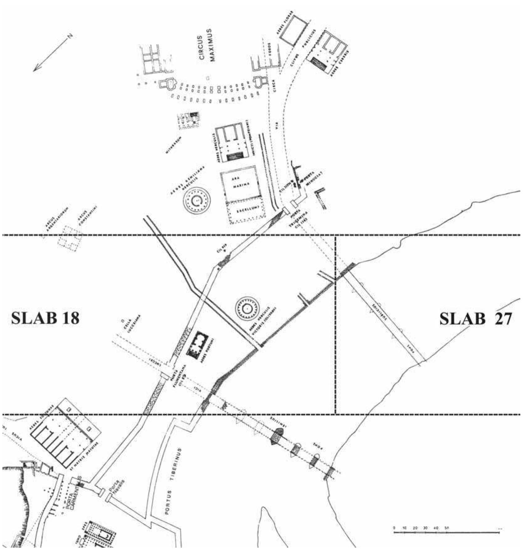
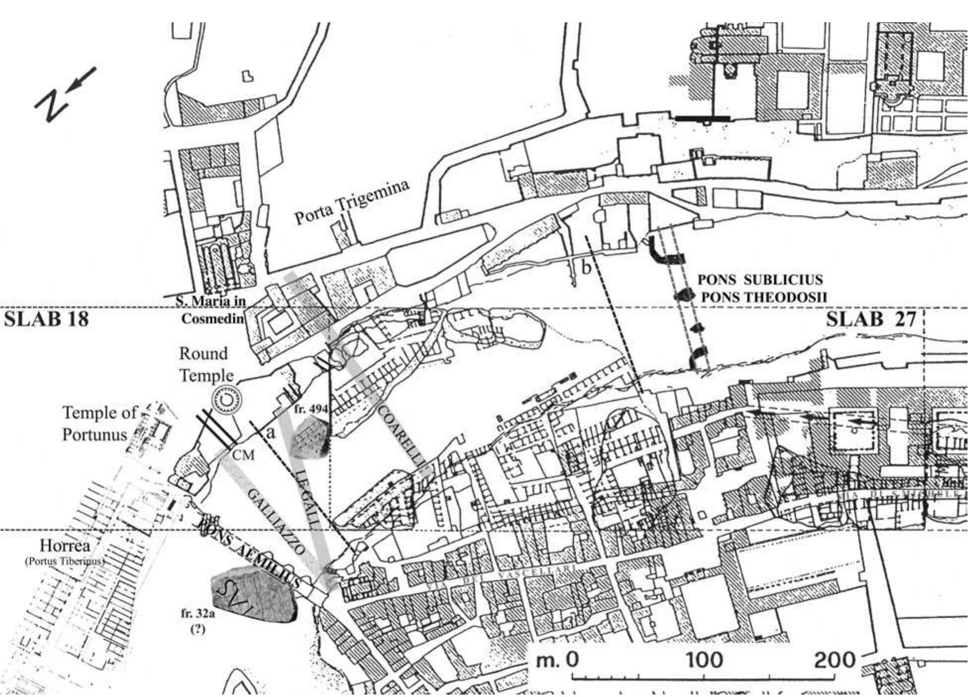
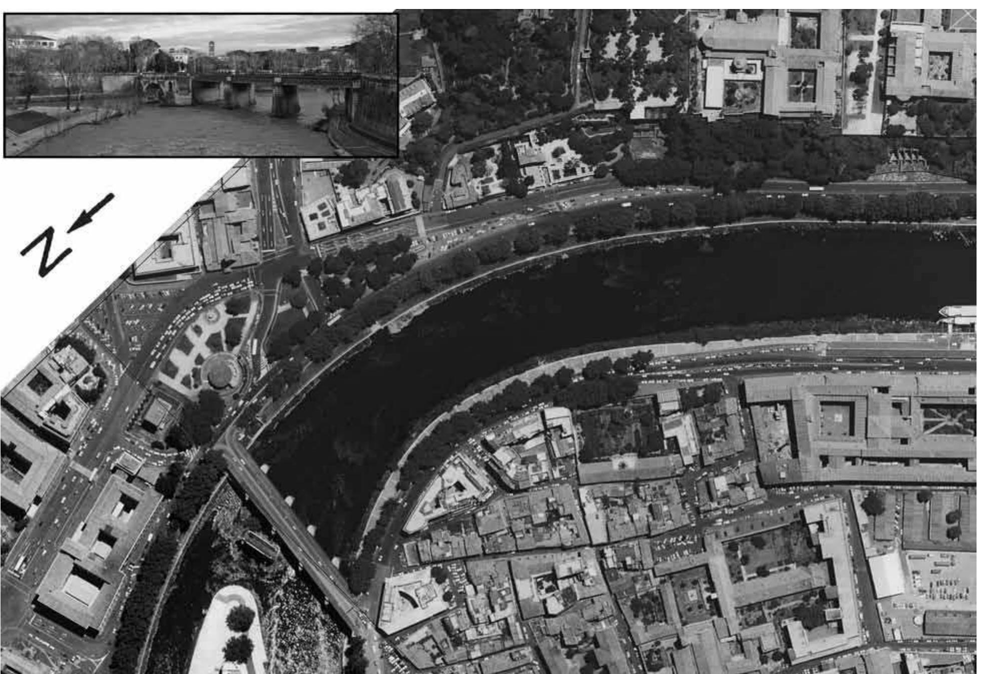
![he was beginning his studies in Rome” and “very summarily adjourned up only to 1950,” and that “this weakness is particularly glaring in his extremely schematic treatment of . . . the site of Rome and the Sublician bridge.”” It is also worth noting that Le Gall’s book was published before the 1960 edition of the Marble Plan, in which Guglielmo Gatti highlighted that “il tratto di fiume rappresentato in questo frammento [slab 27] corrisponderebbe . . . alla zona in cui, successivamente al tempo della pianta, venne costruito il Pons Prob” (on this bridge, see below) and also stressed that “non apparirebbe in esso il Ponte Sublicio che doveva essere situato piu’ a nord, cioé piu’ a sinistra del frammento” (apparently Gatti was influenced by Le Gall’s plan).* However Le Gall’s location of the Pons Sublicius is now called into question by the “new” fragment 494 of the Forma Urbis, the identification of which is presented published in 1960 (in other words, Le Gall’s location of the bridge was not conditioned by the topography depicted on the fragments of the Forma Urbis). In his updated edition (Le Gall 2005, 227), Le Gall is aware of the identification of this fragment. 23 Brown 1954.](https://figures.academia-assets.com/33141089/figure_004.jpg)