Showing posts with label NRO. Show all posts

Monday, 8 December 2025

NROL-77, probably a new NOSS (or maybe not)

click map to enlarge

On 9 December 2025 between 19:06 and 19:28 UTC, SpaceX will launch the classified mission NROL-77 for the NRO, from SLC-40 in Cape Canaveral. The NRO Press Kit is here.

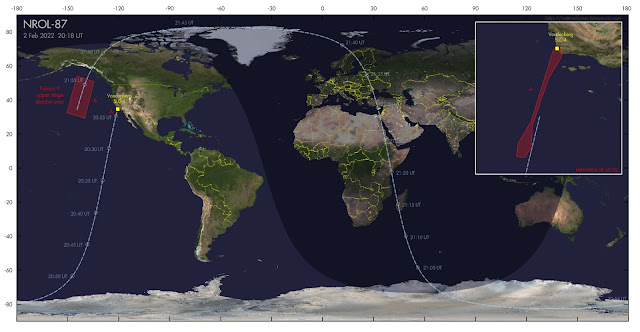
Navigational Warnings point to initial launch into a ~49 degree inclined coasting orbit. Upon passing the descending node of that parking orbit, about an hour after launch, the Falcon 9 upper stage with payload will manoeuver into a ~63.4 degree inclined orbit, likely ~1000 x 1200 km. The upper stage deorbits at the end of the first revolution, in the eastern Pacific.

I initially briefly comtemplated a higher, more unusual orbit, at 1950 km altitude, based on the ~14 minute daily shift backwards of the launch window (as gleaned from Navigational Warning NAVAREA IV 1337). That was an overinterpretation (I blame the COVID infection I suffered the past week, it messes with the brain): the NOSS-like 1000 x 1200 km orbit is more likely and it fits the location and shape of the upper stage deorbit area well.

So this could be a new NOSS (Naval Ocean Surveillance System) duo of SIGINT satellites. Or maybe not, after the experience with NROL-85 in 2022 (see earlier blog post here) which featured only one payload, not two as is typical for NOSS missions. We'll see.

Below are the relevant Navigational Warnings, and two search orbits, one for the coasting orbit (valid untill ~1 hour after launch), the second for the payload(s). 


040948Z DEC 25
NAVAREA IV 1337/25(11,26).
NORTH ATLANTIC.
FLORIDA.
1. HAZARDOUS OPERATIONS, ROCKET LAUNCHING 
   091906Z TO 092010Z DEC, ALTERNATE
   101852Z TO 101956Z, 111838Z TO 111942Z,
   121824Z TO 121928Z, 131810Z TO 131914Z,
   141756Z TO 141900Z AND 151742Z TO 151846Z DEC
   IN AREAS BOUND BY:
   A. 30-50.00N 078-10.00W, 32-12.00N 077-07.00W,
      32-27.00N 076-28.00W, 32-03.00N 075-57.00W,
      31-38.00N 076-07.00W, 30-40.00N 077-57.00W.
   B. 28-39.69N 080-38.17W, 28-52.00N 080-15.00W,
      28-45.00N 080-03.00W, 28-29.00N 080-22.00W,
      28-27.61N 080-31.56W.
2. CANCEL THIS MSG 151946Z DEC 25.//


040904Z DEC 25
NAVAREA XII 789/25(21,22,83).
PACIFIC OCEAN.
1. HAZARDOUS OPERATIONS, SPACE DEBRIS
   1731Z TO 2200Z DAILY 09 THRU 15 DEC
   IN AREA BOUND BY
   12-02.00N 112-31.00W, 12-58.00N 114-47.00W,
   00-49.00S 120-38.00W, 01-46.00S 118-25.00W.
2. CANCEL THIS MSG 152300Z DEC 25.//


Search orbits:

NROL-77 PARKING                 for launch on 9 Dec 2025 19:06:00 UTC
1 70000U 25999A   25343.79583334  .00000000  00000-0  00000-0 0    03
2 70000 049.1163 258.3583 1136647 049.6536 329.5142 13.42495109    02

NROL-77 NOSS payloads           for launch on 9 Dec 2025 19:06:00 UTC
1 70001U 25999A   25343.83680556  .00000000  00000-0  00000-0 0    03
2 70001 063.4415 271.5212 0133723 213.5444 360.0000 13.42495109    02


image: NRO

 (with thanks to Ted Molczan for discussions)

Sunday, 26 May 2024

The NROL-146 payloads: observing the 'train' of 21 Starshield satellites

On May 22, 2024, at 08:00:20 UTC, SpaceX launched a Falcon 9 from Vandenberg SLC-4 as NROL-146, carrying 21 classified payloads for the NRO.

It is the first operational launch of a 'proliferated architecture' (meaning: launching a lot of the same payloads, creating redundancy and with that less vulnerability to failure or countermeasures). The mission motto was: 'Strength in Numbers'.

Based on previous SDA Tranche 0 launches, I initially guessed that they would go in a ~900 km orbit. But on May 22 near 23:08 UTC, Spanish meteor cameras operated by the SPMN recorded a Starlink 'train' like phenomena low in the northern sky, with the 'train' entering Earth shadow around 23:08:10 UTC. I identified it as likely NROL-146, as the orbital plane would indeed pass over southern Europe around the time of observation. Time of observation and shadow entry itself however suggested a much lower orbital altitude, near 300 km, than my initial estimate.

The next two days I was clouded out, but yesterday evening (25-26 May), the sky finally cleared. Just after local midnight, I observed the 'train' from Leiden, counting 21 objects that passed over a 4-5 minute timespan. The 4-minute video above shows all 21 objects. They were very bright (magnitude +2 to +3).

If you get a 'Starlink'-vibe from the video, that is because they basically are. Built by SpaceX and Northrop Grumman, "Starshield" is a military version of Starlink, likely built on the same type of bus. 

Observations so far suggest they were launched into a ~310 km, 69.7 degree inclined orbit. Over the coming days and weeks they will disperse along their orbital plane, and likely also raise their orbital altitude.


click to enlarge

Below is a very cautious elset for the leading object:


NROL-146 obj A                                           310 x 311 km
1 70006U 24999A   24146.90436495 0.00000000  00000-0  00000+0 0    05
2 70006  69.7199  66.3577 0000678 155.5007 204.6228 15.87074186    05

Wednesday, 27 March 2024

NROL-70, likely an ADVANCED ORION satellite

NROL-70 launch trajectory. Click map to enlarge


On 28 March 2024, if weather cooperates (see update at bottom of post), ULA will launch NROL-70 from SLC-37 at Cape Canaveral, carrying a classified payload for the National Reconnaissance Office (NRO). 

NROL-70 will be the last launch of ULA's iconic Delta IV Heavy rocket. Navigational Warnings for the launch (plotted on the map above) indicate a launch to Geosynchronous orbit. The launch window opens at 17:40 UTC and runs to 22:51 UTC. Back-up dates are March 29 to April 1. 

The classified payload is likely Mentor 10 (Orion 12), a Signals Intelligence (SIGINT) satellite in the ADVANCED ORION class.

The NRO launch patch for NROL-70 features a Snow Leopard:


NRO launch patch for NROL-70


ADVANCED ORION/MENTOR satellites are very large. At magnitude +8, they are the brightest geosynchronous satellites in the sky. In a 2010 speech a former Director of the NRO, Bruce Carlson, called one of these, the NROL-32 payload (Mentor 5), "the largest satellite in the world". 

The satellites feature a very large parabolic unfoldable mesh antenna, with estimates of the size of this antenna ranging from 20 to 100 (!) meter. An NSA internal newsletter from 2009 that was leaked as part of the Snowden files, contains an artist impression of the satellite which indeed features a large mesh dish antenna:


ADVANCED ORION artist impression from a 2009 leaked NSA newsletter


These ADVANCED ORION satellites (also known as 'Mission 7600') are huge listening 'ears' in the sky, monitoring large areas for radio emmissions, notably military COMINT (communications) and FISINT, as outlined in this leaked NSA document.

Here is an image of one of these ADVANCED ORION satellites, Mentor 4, imaged by me in January 2020. Note how much brighter it is, due to its size, than the nearby commercial geosynchronous satellite Thuraya 2 (that it is close to this commercial telecom satellite is no coincidence, see my 2016 article in The Space Review linked below):


click image to enlarge


From the Navigational Warnings for the launch and what we know of earlier ADVANCED ORION launches (see my 2016 Space Review paper), NROL-70 will first follow a low altitude (~200 km) coasting orbit. Near the descending node, some 25 minutes after launch, it will then boost into a Geosynchronous Transfer Orbit, which some 6 hours after launch will deliver the payload to a Geosynchronous orbit.


NROL-70 launch trajectory. Click map to enlarge


It initially will likely be placed near longitude 100 E, over Indonesia and within range of the Pine Gap facility in Australia, where it will undergo checkout. It will then be moved to its operational slot, which is unknown.

Initial control will be from the joint US/Australian Pine Gap facility in Australia. Depending on where its operational position will be, control at some point might be handed over to RAF Menwith Hill in the UK.

More backgrounds on the role of these kind of SIGINT satellites can be found in this 2016 article in The Intercept and in my 2016 article in The Space Review.

Here is the text of the relevant Navigational Warning (the three hazard areas A, B and C have been plotted by me as red boxes in the map above):


191855Z MAR 24
NAVAREA IV 333/24(GEN).
NORTH ATLANTIC.
FLORIDA.
1. HAZARDOUS OPERATIONS, ROCKET LAUNCHING
   281740Z TO 282251Z MAR, ALTERNATE
   291737Z TO 292251Z MAR AND 011725Z TO 012251Z
   APR IN AREAS BOUND BY:
   A. 28-34.73N 080-34.39W, 28-37.00N 080-20.00W,
      28-34.00N 079-44.00W, 28-30.00N 079-45.00W,
      28-28.00N 080-20.00W, 28-28.88N 080-32.26W,
      28-30.00N 080-32.80W, 28-33.65N 080-34.05W.
   B. 28-31.00N 073-23.00W, 28-22.00N 070-35.00W,
      27-51.00N 070-38.00W, 27-58.00N 073-22.00W.
   C. 22-05.00N 042-25.00W, 22-29.00N 042-17.00W,
      20-36.00N 036-57.00W, 20-22.00N 037-03.00W.
2. CANCEL THIS MSG 012351Z APR 24. 


Below are very approximate orbit estimates for the various phases of the launch. They are valid for launch on 28 March 2024, 17:40 UTC:


NROL-70 COASTING PHASE                        (valid 17:45-18:05 UTC)
1 70000U 24999A   24088.73611111  .00000000  00000-0  00000-0 0    06
2 70000 028.4000 281.1702 0007584 097.3393 339.7290 16.21678257    00

NROL-70 GTO PHASE                             (valid 18:05-23:30 UTC)
1 70001U 24999A   24088.75364583  .00000000  00000-0  00000-0 0    07
2 70001 028.4000 281.0464 7360043 179.7976 360.0000 02.21326367    09

MENTOR 10 initial placement guess              (valid from 23:30 UTC)
1 70002U 24999A   24088.98149645 0.00000000  00000-0  00000+0 0    02
2 70002   5.0000 278.2000 0001186 360.0000   2.0110  1.00277482    05

The last, Geosynchronous orbit assumes initial orbit placement at longitude 100 E at an initial orbital inclination of 5 degrees.

NRO Press kit for NROL-70
ULA Press kit for NROL-70


UPDATE 27 March 17:35 UTC:

Currently the weather forecast for 28 March does not look very positive, so launch might be postponed.

Wednesday, 20 March 2024

NROL-123

click map to enlarge

In the early hours of March 21, at 6:40 UTC, Rocketlab will launch an Electron rocket from Launch Complex 2 on Wallops, Virginia. The launch, designated NROL-123 and nicknamed "Live and Let Fly", will carry three small classified experimental payloads into Low Earth Orbit for the National Reconnaissance Office (NRO) . 

Navigational Warnings suggest (initial) launch into a ~47.5 degree inclined orbit. The launch trajectory will pass very close to Bermuda (see map above). According to the Rocketlab Press kit, payload release is 54 minutes after launch, after approximately half an orbital revolution. As release is near the ascending node, it is possible that the kick stage will insert the payloads into somewhat different orbital inclination(s). Orbital altitude will likely be in the order of 600-700 km.

Little is known about the character of the payloads and the type of orbit does not give a clue either.  The NRO Press kit mentions that "NROL-123 will carry three collaborative research missions". The NRO Mission patch for NROL-123 features three hexagons with respectively a dragonfly, a sunfish (Mola), and wasps. The Rocketlab launch patch also similarly features a stylized dragonfly, a fish, and a wasp.


NROL-123 Mission patch (image: NRO)


The NRO Press kit says about these symbols that: 

"The dragonfly symbolizes energy, youthful exuberance, and accomplishment - representing the use of new technology. The position of it flying through the hexagon symbolizes a new frontier, new opportunity, and new perspective. The forward movement represents the critical path of the mission. The bees are based on the idea of “small but impactful” and represent the tremendous impact the program experiments will have on the NRO mission. The sunfish, or mola, nods toward the program". 

Which is all not very enlightening, especially where the meaning of the sunfish is concerned (and they should make up their mind if it are bees or wasps - they look like the latter to me).

Here is my very cautious estimate of the launch orbit. Orbital altitude is a bit of a guess, and there is some leeway in the orbital inclination possible too:

NROL-123                     for launch on 21 March 2024 06:40:00 UTC
1 70000U 24999A   24112.27777778  .00000000  00000-0  00000-0 0    05
2 70000 047.5000 101.3672 0002846 134.5077 326.5399 14.73474122    04

Below is the relevant Navigational Warning for this launch (see the map in top of the post for a plot of the indicated areas):

150916Z MAR 24
NAVAREA IV 296/24(GEN).
WESTERN NORTH ATLANTIC.
VIRGINIA.
1. HAZARDOUS OPERATIONS, ROCKET LAUNCHING 
   210615Z TO 211030Z MAR, ALTERNATE 
   0615Z TO 1030Z DAILY 22 THRU 25 MAR
   IN AREAS BOUND BY:
   A. 37-51.00N 075-30.00W, 37-52.00N 075-29.00W,
      37-56.00N 075-17.00W, 38-19.00N 074-35.00W,
      37-35.00N 074-11.00W, 37-15.00N 074-20.00W,
      37-23.00N 075-18.00W, 37-30.00N 075-29.00W,
      37-44.00N 075-30.00W, 37-48.00N 075-31.00W,
      37-49.00N 075-31.00W, 37-50.00N 075-31.00W,
      37-50.00N 075-31.00W.
   B. 35-02.00N 070-55.00W, 35-56.00N 069-54.00W,
      33-15.00N 065-46.00W, 32-19.00N 066-46.00W.
   C. 27-19.00N 061-16.00W, 27-54.00N 060-27.00W,
      24-27.00N 056-36.00W, 23-50.00N 057-26.00W.
2. CANCEL THIS MSG 251130Z MAR 24.

Wednesday, 20 April 2022

USA 327 / NROL-85


The video above which I shot yesterday evening (19 April 2022) shows USA 327, the NROL-85 payload, passing over my home in Leiden, slightly over two days after it was launched. The footage was shot with a WATEC 902H2 Supreme Low Light Level CCTV camera with a Canon FD 1.8/50 mm lens fitted.

NROL-85 (see two previous posts about this very recent classified launch here and here) has now been catalogued (with orbital elements witheld) by CSpOC as USA 327, catalogue nr 52259, COSPAR ID 2022-040A. Only one object was catalogued, there was no spoof second 'debris' object entered.

As already mentioned in a recent post, the fact that there is no second object is a big surprise. We expected NROL-85 to deliver two payloads, a pair of INTRUDER (also known as NOSS, which stands for Naval Ocean Surveillance System), SIGINT satellites used for geolocating shipping on the High Seas by means of time difference of arrival of their radar/radio emmisions.

Before 2001, NOSS systems existed of three co-orbiting satellites forming a thight triangular formation. From 2001 onwards (with the launch of NOSS 3-1, the first of the Block 3 NOSS-es) , this changed into two co-orbitting satellites.

(the video below, from 30 August 2018, shows a typical NOSS pair, in this case both briefly flaring due to a favourable sun-satellite-observer angle on some reflecting part of the satellites. While operational, NOSS pairs always move this close together. The NOSS pair in question is  NOSS 3-6, the same NOSS pair into which orbital plane the new USA 327 satellite was launched).


And now, we have only one, not two, satellite launched in a NOSS-like orbit. Analysts are scratching their heads over this.

Given the strong similarity in orbit, and the fact that it was launched into the orbital plane of an existing 10-year-old NOSS pair (see previous post), NOSS 3-6 (2012-048A & P), there is clearly some conceptual link of the new satellite to the NOSS program

But in what way exactly? There are a couple of options:

(1) This is a new generation of NOSS/INTRUDER, (i.e. NOSS block 4-1), that needs only one satellite;

(2) This is something else, something new, but related to NOSS/INTRUDER;

(3) This was meant to be NOSS 3-9, a regular NOSS pair, but something went wrong and the second satellite was not deployed;

(4) There is a second satellite but it is small (cubesat) and not yet detected;

(5) The second satellite still has to detach from the first


So let us briefly comment on these various options:

Option (1) apparently, is feasible, according to some. Apparently it is possible to do TDA using just one satellite

With regard to option (2), the most interesting one, one could think of for example an optical or radar counterpart to the existing NOSS 3-6 SIGINT pair: one that images the ships geolocated by NOSS 3-6. This makes sense (and it also makes sense that the new satellite orbits half an orbit apart from the NOSS pair).

While we cannot exclude option (3), I think it is not the most likely option. The same goes for option (5): with previous NOSS launches, two objects were detected right after launch. I have no opinion on option (4).

If we look at the current orbit of USA 327 and the orbit of the NOSS 3-6 pair, we note that: 

(a) they move in almost the same orbital plane; 

(b) they currently are almost exactly half an orbital revolution apart (see illustration below); 

(c) because of the latter difference in Mean Anomaly, their ground tracks are not the same but have some distance between them.


click map to enlarge

Observation (c) does not entirely make sense to me. Wouldn't you want your imaging satellite to follow the same ground track as the geolocating SIGINT satellites? On the other hand: true: the footprints are large enough to cover a large overlap in ocean space from both groundtracks. But still....

Another aspect of this that does not completely make sense to me is that, if USA 327 is a technology demonstrator for a new complementary IMINT mode to the NOSS SIGINT system, then why pick a 10-year-old, nearly retired pair of NOSS satellites to test it with? Why not pick a fresher pair, so you can happily experiment away for the time to come?

But maybe, those fresher pairs of NOSS satellites are deemed more suited for when, after this technology demonstration, the truely operational system is deployed. But then again, why bother with that, just replace the technology demonstrator with the operational version and deorbit the technology demonstrator.

Questions, so many questions, and my still post-COVID impaired brain cannot make much sense of it yet...

It will be interesting to see what USA 327 does (in terms of orbital manoeuvres etcetera) the coming months.

Meanwhile, Radio observer Scott Tilley in Canada has detected the first S-band radio signals from USA 327. He reports "huge fades in signal", which is odd. From Cees Bassa I understand that the frequency in question, 2277.5 MHz, is a know frequency used during the checkout-phase of NOSS 3-x pairs.

Monday, 18 April 2022

NROL-85 observed, but is it an INTRUDER/NOSS or something else? [UPDATED]

click image to enlarge


Yesterday 17 April 2022 at 13:13 UT, SpaceX launched the classified NROL-85 mission for the NRO. Before the launch we widely expected this to be NOSS 3-9, a new pair of INTRUDER/NOSS satellites (see previous post), based on clues as to the orbit it was launched into. 

The orbital inclination and orbital altitude suggested by OSINT infornation on the mission were typical for NOSS/INTRUDER, and the time of launch indicated a launch into the orbital plane of the 10-year-old NOSS duo NOSS 3-6. That is a pattern we have seen before with NOSS missions: a replacement launched into the same orbital plane after 10 years of operational service.

So we expected to observe two objects after launch. 

But NROL-85 had a surprise in store: so far, we detected only one object, not the expected two!

This leads to the question: is NROL-85 a new INTRUDER/NOSS, or not?

NROL-85 was first picked up by me, from Leiden, the Netherlands, some 7 hours after launch, in late evening twilight of 17 April around 19:59 UT (21:59 CEST). It was some 2.5 minutes early on my pre-launch estimated search elset. I subsequently also observed it on a second pass two hours later.

On the first pass, I captured it photographically (see image in top of this post, showing it above the roof of my house along with two old unrelated rocket stages), using a Canon EOS 80D with a Samyang 1.4/35 mm wide angle lens (the exposure is a 2-second exposure at ISO 800). The video system I had set up captured it too, but only very briefly in a corner of the field of view. Only one object was seen, nothwithstanding that I did a photographic plane scan during quite some time.

The second pass was in the northern sky with a less favourable phase angle (so the object was much fainter than during the first pass). I captured it with the video system, and after following it for a minute or so, left the camera stationary to look for a possible second object. None was detected, either before or after the detected object.

Likewise, fellow observers from the Seesat-L list including David Brierley and Eelke Visser, detected only one object too. And Scott Tilley reports that he did not detect radio signals at the frequencies usually used by NOSS.

The absence of a second object could mean that NROL-85 is not a new INTRUDER/NOSS mission after all, but something else, although the orbit is very NOSS-like.

Alternatively, perhaps it is an improved version of INTRUDER that now needs only one satellite, rather than two.

NOSS missions once consisted of three satellites orbiting close together in a triangular formation. In 2001 this changed to two satellites. Maybe now they found a way to do it with one satellite?

The object we detected is in a 1021 x 1191 km, 63.5 degree inclined orbit (update: with a longer observational arc constraining the eccentricity of the orbit better, the new value is ~ 1008  x 1207 km). This orbit is close to the specifications given in a launch contract tender for NROL-85. Below is a preliminary initial elset based on a 5.5 hour observational arc:

NROL-85 (USA 327)
1 70002U 22999A   22108.04497945 0.00000000  00000-0  00000+0 0    07
2 70002  63.5043 123.5866 0114230 185.9890 173.9785 13.40421486    07

rms 0.024 deg

Elset update (20 April 2022): Below is the latest elset based on 114 observations by Cees Bassa, Eelke Visser, David Brearley, Andriy Makeyev and me over a two-day observational arc:

USA 327 (NROL-85)                                      1008 x 1207 km
1 52259U 22040A   22109.98456423 0.00000000  00000-0  00000+0 0    08
2 52259  63.4462 118.5572 0132890 178.9713 181.1610 13.40467640    01

rms 0.011 deg    arc Apr 17.83 UT - Apr 20.01 UT


click to enlarge


As a final note: the post-deorbit-burn fuel vent by the Falcon 9 upper stage used for the launch of NROL-85, which was deorbitted over the Pacific Ocean at the end of the first revolution (see map in previous post), was seen and filmed from Hawaii, showing the characteristic spiral shape:


(a follow-up post is here)

Tuesday, 12 April 2022

NROL-85: probably NOSS 3-9, a new pair of INTRUDER Naval SIGINT satellites


image: Wikipedia

 EDIT (15 & 16 Apr):  the launch of NROL-85 has been postponed by at least two days, 'due to technical difficulties'

EDIT (17 Apr): new launch date is 17 April 2022 13:13 UT

On 15 April 2022, at 13:41 UT (or later) according to a tweet by the NRO, SpaceX will launch NROL-85 for the National Reconnaissance Office (NRO). The launch will be from SLC-4E at Vandenberg SFB. [edit 16 Apr: launch was postponed to 17 April 13:13 UT]

NROL-85 is almost certainly a pair of NOSS satellites. NOSS stands for Naval Ocean Surveillance System; they are also known under the code name INTRUDER. If correct, the duo would become NOSS 3-9 (the 9th mission of block III). It will probably enter with the designation USA 327 in the CSpOC catalogue (with orbital elements witheld).

NOSS satellites are SIGINT satellites operated by the US Navy. They geolocate shipping on the high seas, by detecting their radio/radar emissions. They always operate in close pairs. The secondary object is usually listed (with orbital elements witheld) as "debris" in the CSpOC catalogue, but this is a ruse that fools nobody: it is a payload too that manoeuvres and keeps a careful constant close distance to the primary satellite.

Information from the launch contract tender for this launch reveals that the mission aims for a semi-major axis of  7500.5 km, an orbital eccentricity of 0.0131, an orbital inclination of 63.535 degrees and an argument of perigee of 190 degrees (i.e. perigee almost on the equator). The listed semi-major axis and eccentricity translate to a 1024 x 1221 km orbit

The combination of the 63.5 degree orbital inclination and 1024 x 1221 km orbit strongly points to a NOSS/INTRUDER mission. These typically have an orbital inclination of 63.4 degrees and a semi-major axis of 7485 km, values close to those quoted for NROL-85. If launch is indeed at 13:13 UT on April 17, the resulting orbital plane will be very similar to that of the existing NOSS 3-6 duo (2012-048A and 2012-048P) which was launched in 2012, as can be seen in the figure below. That also lines up with a new NOSS-launch: NOSS-pairs are typically replaced after 10 years on-orbit.

The shift in launch time with date due to the two launch postponements agree with the estimated orbital altitude and orbital plane and matches the nodal precession of a typical NOSS orbital plane.


click image to enlarge


The Navigational Warnings for this launch (NAVAREA IV 336/22 NAVAREA XII 228/22 and HYDROPAC 987/22) define a launch direction towards the south-southeast, and agree with the 63.5 degree orbital inclination of the launch contract tender. 


[EDIT: The first NavWarning has been corrected: I initially copied the wrong NavWarning for this post.....]

100706Z APR 22
NAVAREA XII 228/22(18,21).
EASTERN NORTH PACIFIC.
CALIFORNIA.
1. HAZARDOUS OPERATIONS 1150Z TO 1514Z DAILY
   15 AND 16 APR IN AREAS BOUND BY:
   A. 34-41N 120-38W, 34-39N 120-40W,
      34-28N 120-38W, 34-04N 120-17W,
      34-04N 120-05W, 34-19N 120-14W,
      34-39N 120-19W.
   B. 32-03N 118-53W, 32-01N 118-49W,
      30-51N 117-56W, 30-21N 117-39W,
      30-08N 117-47W, 30-11N 118-01W,
      30-32N 118-18W, 31-54N 118-53W.
2. CANCEL THIS MSG 161614Z APR 22.


100644Z APR 22
HYDROPAC 987/22(22,83).
EASTERN SOUTH PACIFIC.
DNC 06.
1. HAZARDOUS OPERATIONS, SPACE DEBRIS
   1425Z TO 1649Z DAILY 15 AND 16 APR
   IN AREA BOUND BY
   20-12S 123-30W, 19-00S 119-00W,
   33-48S 109-30W, 36-00S 114-12W.
2. CANCEL THIS MSG 161749Z APR 22.


I have mapped the hazard areas from the Navigational Warnings and the resulting launch trajectory in the map below (the times listed along the trajectory are in UT and for the updated launch date with launch at 13:13 UT (17 April):
 

click map to enlarge


Based on the parameters from the launch contract tender, this is my orbital estimate, valid for launch at 13:41 UT on April 15 updated for launch at 17 April 13:13 UT:


NROL-85                         for launch on 17 Apr 2022 13:13:00 UT
1 70002U 22999A   22107.55069445 0.00000000  00000-0  00000+0 0    02
2 70002  63.5350 124.8521 0131000 190.0000 291.3542 13.36458926    04


There is an uncertainty of several minutes in pass time in this elset, progressively so after more than one revolution, and some cross-track error is possible. But the elset should be good enough for a plane scan, taking a wide time window around a predicted pass. Be carefull not to misidentify the NOSS 3-6 duo as NROL-85. An elset for NOSS 3-6 can be found here.

If the eventual launch time turns out to be later than 13:13 UT, the elset above can easily be adjusted to match the new launch time using my "TLE from Proxy" software downloadable here.

The Northern hemisphere will see good, fully illuminated evening passes on the day of launch and the days after it, so prospects are good for a quick on-orbit detection after launch.

The Falcon 9 upper stage deorbit is over the southern Pacific, just after the end of the first revolution. The deorbit-burn might be visible from south and/or central Asia.

The launch patch (see top of this post) features a cat, with a tiger as its reflection. The NRO itself explains some of the symbolism in the patch in this way:

"In the NROL-85 patch, the 3 stars represent guidance, protection, and allegiance. The cat represents loyalty and devotion shared among our nation and partners. The tiger in the cat’s reflection demonstrates that while space can be challenging, a determined attitude helps NRO succeed in going"


Given that this is going to be NOSS 3-9, the 9th instance of the Block III NOSS generation, I wonder if the cat was inspired by the proverbial 'nine lives' of cats.

It is possible that a number of other small satellites will be included in this launch as a rideshare.

The NRO press kit for NROL-85 is downloadable here.

FOLLOW-UP POST HERE reporting the first observations of NROL-85 from the evening of April 17. NROL-85 might not be an INTRUDER/NOSS after all!

A SECOND FOLLOW-UP POST HERE, going a bit deeper into various speculations about what the NROL-85 payload might be.


[a small update to this post was made 13 April 2022 09:00 UT, adding a bit more background information]

[an error where I had initially copied the wrong text of a NavWarning into this post was corrected at 13 Apr 20:30 UT - many thanks to the anonymous sharp-eyed reader who noted it!] 

[updated April 15 & 16 to reflect launch postponements] 

[updated 17 Apr 8:45 UT with updated launch trajectory map and orbital plane diagram]

Wednesday, 2 February 2022

The upcoming classified NROL-87 launch

click map to enlarge


If weather cooperates, SpaceX will launch a classified payload for the National Reconnaissance Office (NRO) on 2 February 2022 at 20:18 UT [the launch eventually was at 21:27 UT]. This launch, from Vandenberg SLC-4 in California, is designated NROL-87.

Both (limited) specifications in a published contract for this launch (which states the intended orbital inclination and semi-major axis as respectively 97.4 degrees and 6890.7 km), as well as the position and orientation of hazard zones published in Navigational Warning NAVAREA XII 45/22 point to a launch into a 97.4 degree inclined, Sun-Synchronous Low Earth Orbit at about 512 km orbital altitude.

Analysts suspect the classified payload is one of a new generation of electro-optical IMINT satellites (either the first, or possibly the second, after USA 290/NROL-71, but in the latter case in a clearly different orbit) that is a follow-up to the KH-11 program. The sun-synchronous character of the intended orbit supports interpretation as an IMINT mission.

The image in top of this post gives the launch trajectory. The hazard areas I plotted in the map are from Navigational Warning NAVAREA XII 45/22 and they match a launch into an orbital plane with the quoted orbital inclination of 97.4 degrees:

280731Z JAN 22
NAVAREA XII 45/22(17,18,19).
EASTERN NORTH PACIFIC.
CALIFORNIA.
1. HAZARDOUS OPERATIONS:
   A. 1907Z TO 2138Z DAILY 02 AND 03 FEB
      IN AREA BOUND BY
      34-42N 120-41W, 34-41N 120-32W,
      34-31N 120-26W, 34-18N 120-30W,
      33-40N 120-53W, 32-10N 121-24W,
      31-25N 121-27W, 31-07N 121-40W,
      31-09N 121-55W, 31-35N 121-52W,
      32-17N 121-27W, 34-29N 120-46W.
   B. 2110Z TO 2249Z DAILY 02 AND 03 FEB
      IN AREAS BOUND BY
      54-00N 144-30W, 50-45N 134-30W,
      29-15N 140-00W, 32-30N 150-30W.
2. CANCEL THIS MSG 032349Z FEB 22.


The Falcon 9 upper stage from the launch makes a controlled reentry at the end of the first revolution, in the Northeast Pacific roughly between Alaska and Hawaii (the red box marked "B" in the map above). 

If launch is indeed near 20:18 UT (the launch window of the Navigational Warning runs from 19:07 to 21:38 UT), then the orbital plane launched into results in passes near noon and midnight local time and (if the semi-major axis is correct) a ~5-6 day repeating ground track. A pre-launch estimated elset is here.

The Launch Patch for NROL-87 shows an Ibex keeping a watchfull eye over its territory:


image: NRO

Saturday, 12 June 2021

NROL-111 and TacRL-2: two upcoming classified launches [UPDATED]

click map to enlarge


Two classified launches are slated for the second week of June. One is the launch of TacRL-2, on 13 June at 8:11 UT. The other is NROL-111 on June 15 between 10:00 and 15:30 UT [edit: a potential launch time of 11:00 UT has now been announced]. Both are launched by Northrop Grumman, on behalf of respectively the Space Force and the NRO.


TacRL-2

TacRL-2 is described as a "Space Domain Awareness" technology demonstration satellite that is part of the "Tactically Responsive Launch Program" (hence "TacRL") of the US Space Force. The satellite was reportedly developed in less than a year time.

It will be an airborne launch, on one of two remaining Northrop Grumman Pegasus-XL rockets carried by a Lockheed L1011 Tristar aircraft. The launch will be over the Pacific, near California.

The Navigational Warnings issued point to launch into a polar Low Earth Orbit with orbital inclination near 96 to 98 degrees. Below are the Navigational Warnings, which I have also mapped in the map above:

090844Z JUN 21
NAVAREA XII 257/21(18,83).
EASTERN NORTH PACIFIC. 
CALIFORNIA. 
1. HAZARDOUS OPERATIONS 0739Z TO 0855Z DAILY 
   13 AND 14 JUN IN AREAS BOUND BY:
   A. 35-19N 123-44W, 35-13N 122-58W, 
      31-11N 124-05W, 31-16N 124-30W.
   B. 29-34N 125-03W, 29-28N 124-29W, 
      27-32N 124-53W, 27-38N 125-26W.
   C. 20-19N 127-23W, 20-02N 125-41W, 
      15-26N 126-30W, 15-43N 128-11W.
   D. 01-20N 131-46W, 00-35N 127-20W, 
      01-52S 127-44W, 01-06S 132-11W.
2. CANCEL THIS MSG 140955Z JUN 21.
 
080051Z JUN 21
HYDROPAC 1691/21(83).
EASTERN PACIFIC.
DNC 06, DNC 13.
1. HAZARDOUS OPERATIONS, SPACE DEBRIS 130809Z TO
   130840Z JUN AND 140809Z TO 140840Z JUN
   IN AREA BOUND BY
   01-20N 131-46W, 00-35N 127-20W,
   01-52S 127-44W, 01-06S 132-11W,
   01-20N 131-46W.
2. CANCEL THIS MSG 140940Z JUN 21.

In my initial assessment I suggested a 98-degree sun-synchronous orbit as a possibility [EDIT: and it turns out that I was right in that: the payload has been catalogued in a 97.48 degree inclined orbit, catalogue nr 48844]; but I have since revised that assessment based on sensible comments by Bob Christy. His ~96-degree inclined orbital suggestion indeed fits the hazard areas well. Yet, my initial suggestion of a sun-synchronous orbit cannot be totally discounted either [EDIT: see earlier remark: it in fact *is* in a sun-synchronous orbit near ~98 degree inclination, and I am therefore very happy that I included this statement...]. In the map in top of this post, I have plotted the 96-degree inclined option.

UPDATE (13 Jun 11:20 UT): TacRL-2 launched successfully. According to the Space Force, the satellite is named Odyssey.

UPDATE (13 Jun 21:00 UT): Odyssey/TacRL-2 has been catalogued by Space-Track under catalogue nr. 48844, in a 405 x 452 km, 97.48 degree inclined orbit. The orbit is, against expectations, not classified.


NROL-111

Two days after TacRL-2, Northrop Grumman will launch another mission, NROL-111, this time for the NRO. The launch will be on June 15,with a launch window between 10:00 and 15:30 UT. [EDIT: in a tweet, the NRO has now announced 11:00 UT as the launch time)

It concerns the launch of three unspecified small payloads on a Minotaur I rocket. The launch will be from Wallops Pad 0B (Press Kit here). The Navigational Warnings (see below) point to launch into a ~50-degree inclined Low Earth Orbit:

110950Z JUN 21
NAVAREA IV 488/21(GEN).
WESTERN NORTH ATLANTIC. 
VIRGINIA. 
1. HAZARDOUS OPERATIONS, ROCKET LAUNCHING
   151000Z TO 151530Z JUN, ALTERNATE 
   1000Z TO 1530Z DAILY 16 THRU 21 JUN 
   IN AREAS BOUND BY:
   A. 37-57-27N 075-27-32W, 37-38-42N 074-52-00W,
      37-24-46N 075-06-02W, 37-41-36N 075-37-02W.
   B. 36-46-37N 074-55-59W, 37-18-40N 074-06-36W, 
      37-01-44N 073-19-30W, 36-27-47N 072-14-49W, 
      35-59-28N 072-14-38W, 35-30-18N 073-03-54W, 
      35-39-00N 074-02-06W.
   C. 30-10-19N 069-45-00W, 33-31-19N 067-19-52W, 
      30-57-14N 064-49-52W, 29-31-30N 067-11-42W. 
   D. 07-00-00N 048-09-43W, 10-19-01N 044-06-50W, 
      06-14-02N 038-38-13W, 01-44-13N 043-46-37W.
2. CANCEL THIS MSG 211630Z JUN 21.


I have plotted the Navigational Warnings in the map below (click to enlarge):

click map to enlarge


We can only speculate about the possible functions of the NROL-111 payloads, and the same is true for TacRL-2 ("Space Domain Awareness" broadly suggests the latter is keeping an eye on other satellites). Both missions appear to be experimental. With regard to NROL-111, I just note that orbital inclinations near 50 degrees lately have become very popular with the NRO for some reason.

Wednesday, 28 April 2021

USA 314 (NROL-82) imaged


click to enlarge

Last Monday 26 April at 20:47:00 UT, ULA launched a classified payload for the NRO under the launch designation NROL-82. The payload is now designated USA 314. I wrote about the launch and that it is almost certainly an ADVANCED ENHANCED CRYSTAL KH-11 electro-optical reconnaissance satellite in an earlier post.

The payload was picked up on the first orbit by radio observer Scott Tilley in Canada, and next, guided by the radio observations, Cees Bassa (who is just like me in the Netherlands) optically imaged it on the second and third orbit.


I tried to image it from Leiden on the second orbit as well, but as it turns out it passed outside my camera field during that pass.

The next night, and with a more firm search orbit based on the data from the previous night available, I did succesfully image it. The photograph in top of this post was made with a Canon EOS 80D camera and Samyang 1.4/85 mm lens (at F2.0, 1600 ISO, 1 second exposure). 

I also obtained video, using the WATEC 902H2 Supreme with a 1.8/50 mm lens:


The payload is designated USA 314 (catalogue nr 48247, COSPAR 2021-032A) and as usual CSpOC does not publish orbital data. But our observations show that it is in a 528 x 755 km, 98.1 degree inclined sun-synchonous orbit.

The orbital plane is even closer to that of USA 224 than anticipated: a difference of only 1.1 degree in RAAN and 0.2 degrees in orbital inclination. The orbital altitude is somewhat different and the orbital eccentricity is less than our initial guess. Perhaps it will manoeuvre over the coming days/weeks to the same altitudes as USA 224, perhaps it will not: we will see!

So in all, the NROL-82 payload's orbit is pretty much what was expected, apart from a slightly different initial orbital altitude.

USA 224 and the new payload USA 314 currently move almost in phase, and as a result they are relatively close, with continuous sight of each other. It is well possible that USA 224 is imaging the new payload as a post-launch health checkup.

The image below shows the coplanar character of the USA 224 and USA 314 orbits, and the spatial proximity in viewing distance of each other:

click to enlarge

As I pointed out in a previous post, based on historical patterns I expect that, after a checkout-phase that may take a couple of weeks, the new USA 314 will take over from USA 224 in the KH-11 primary East orbital plane. USA 224 will then likely be manoeuvered into a lower orbit (~400 km) and its orbital plane will be moved to the 'secondary' East plane, some 10-20 degrees east in RAAN of the current orbital plane.

Tuesday, 15 December 2020

NROL-108: another mystery launch perhaps similar to NROL-76 (USA 276)? [UPDATED]


UPDATE 17 December 2020 16:15 UT:

today's launch was scrubbed due to a pressure anomaly in the upper stage. A new launch attempt will be on December 18th 19th.

UPDATE 20 December 2020 12:20 UT:
NROL-108 launched succesfully on 19 december at 14:00 UT. A fuel dump was observed from New Zealand.


On 17 18 19 December 2020, SpaceX will launch a classified payload for the National Reconnaissance Office (NRO). The launch, from Cape Canaveral platform 39A in Florida, is designated NROL-108. The Navigational Warnings window opens at 13:55 UT and closes at 17:52 UT, pointing to launch somewhere between ~14:00-17:45 UT [edit: the scrub on December 17 suggests a window starting at 14:45 UT and ending at 17:00 UT] . The first stage will attempt to do a RTLS (return-to-launch-site).

NROL-108 is very odd as it was a surprise addition to the launch schedule in early October 2020, seemingly coming out of nowhere. It was originally slated for launch on October 25, but was postponed to December. The character of the mission is a mystery: this looks to be something new again.

The following Navigational Warnings have appeared for the launch hazard areas and the Falcon 9 upper stage deorbit area:

 NAVAREA IV 1201/20
 WESTERN NORTH ATLANTIC.
 FLORIDA.
 1. HAZARDOUS OPERATIONS, ROCKET LAUNCHING
    171355Z TO 171752Z DEC, ALTERNATE
    181355Z TO 181752Z DEC
 IN AREAS BOUND BY:
 A. 28-39-43N 080-38-12W, 29-02-00N 080-15-00W,
    28-57-00N 080-08-00W, 28-40-00N 080-11-00W,
    28-27-00N 080-24-00W, 28-26-52N 080-32-07W.
 B. 30-12-00N 079-06-00W, 30-28-00N 078-56-00W,
    30-54-00N 078-52-00W, 31-14-00N 078-13-00W,
    31-06-00N 077-36-00W, 30-47-00N 077-22-00W,
    30-27-00N 077-26-00W, 30-08-00N 078-20-00W,
    30-03-00N 078-58-00W.
 2. CANCEL THIS MSG 181852Z DEC 20.//


 HYDROPAC 3673/20
 EASTERN PACIFIC.
 DNC 06, DNC 13.
 1. HAZARDOUS OPERATIONS, SPACE DEBRIS
    171508Z TO 171841Z DEC, ALTERNATE
    181508Z TO 181841Z DEC
 IN AREA BOUND BY
    12-27S 135-24W, 11-03S 135-01W,
    04-31N 125-02W, 12-23N 118-23W,
    11-34N 117-22W, 01-11N 123-20W,
    11-32S 132-38W, 13-10S 134-27W.
 2. CANCEL THIS MSG 181941Z DEC 20.//


These hazard areas plotted on a map:

click map to enlarge


The time window for the upper stage deorbit and the fact that the first stage will attempt an RTLS point to a launch into Low Earth Orbit. The launch direction and the location of the Falcon 9 upper stage deorbit area point to a launch into an orbit with an orbital inclination near 52 degrees.

The location of the launch hazard areas is somewhat similar to the launch hazard area for the May 2017 mystery launch of USA 276 (NROL-76). In the map below, the two hazard areas for NROL-108 are in red, while the launch hazard area for NROL-76 (USA 276) from May 2017 is in blue:

click map to enlarge

USA 276/NROL-76 was a mystery NRO launch, like NROL-108 launched by SpaceX, in May 2017, that raised eyebrows because the payload made a series of very close flyby's of the International Space Station a month after launch (see my July 2017 article in The Space Review).

USA 276 went, as subsequent orbital observations of the payload by our amateur network showed, into a ~400 km altitude, 50-degree inclined orbit, so a 50-degree inclined orbit is perhaps also an option for NROL-108.

Such a 50-degrees inclined orbit does not match well with the position of the deorbit zone for the Falcon 9 upper stage. The latter will be deorbitted over the eastern Pacific near the end of the first revolution, the Navigational Warnings show. So for now, the 52-degree inclination (give or take a degree) looks a bit more likely. Still, I do not want to rule out a 50-degree inclined orbit altogether, as the Falcon 9 upper stage might end up in a somewhat different orbit than the payload

In May 2017, USA 276 was launched into an orbital plane very close to that of the ISS, which resulted in the close encounters a month later. 

The launch window for NROL-108 (~14:00-17:50 UT) rules out that NROL-108 will do something similar: the ISS orbital plane does not pass over or near the launch site during this time window. 

It is possible however that NROL-108 aims for an orbital plane near that of USA 276. The orbital plane of USA 276, which due to orbital precession over the past 3 years no longer is close to that of the ISS, passes over Cape Canaveral Launch Pad 39A near 17:02 UT, inside the NROL-108 launch window. This opens up the possibility that NROL-108 is perhaps a close approach target for USA 276, or USA 276 is a close approach target for NROL-108 (but that is pure and wild speculation: Caveat Emptor). [UPDATE: see the update at end of this post. It did not target the USA 276 orbital plane]

It will be interesting to see in which orbit NROL-108 will end up. As I have remarked with some launches earlier  this year, the latest NRO launches all seem to be  'new' kinds of payloads that are likely experimental/Mission demonstrators, and which go into 'new' kinds of orbits: lately we have frequently seen orbital inclinations near 50-degrees and odd orbital altitudes (either very low or very high). NROL-108 will certainly go into a Low Earth Orbit, and it will be interesting to see what the exact launch time will be, whether it will go into a 400 km orbit similar to the orbital altitude of USA 276, and what the eventual orbital inclination will be.


UPDATE 20 December 2020:

NROL-108 launched succesfully at 14:00 UT on December 19th. Slightly over an hour after launch, near 15:15 UT, a fuel dump (following a deorbit burn) from the Falcon 9 upper stage was observed from New Zealand. The facebook-post here shows the classic spiral shape of such a fuel dump. The Youtube video below shot from Pukehina Beach by Astrofarmer shows less detail but includes time details:


Assuming the included times in the video are correct, this allows me to make a new estimate of the orbital altitude in which the satellite was inserted, which is probably ~600 km rather than the ~400 km of my initial estimate, looking at the time the rocket stage passed south of New Zealand:


NROL-108
1 70000U 20999A   20354.58333333  .00000000  00000-0  00000-0 0    04
2 70000 051.9000 194.4979 0003581 047.9699 326.1978 14.88539141    08

The orbital inclination of the satellite is still a bit uncertain but likely ~52 degrees.

The launch time (14:00 UT) excludes that the orbital plane of USA 276 was targetted (the orbital plane of the latter passed over the launch site two hours after launch).


UPDATE 2 (20 Dec 2020):

Radio observers have now catalogued the payload in a 519 x 539 km, 51.35 degree inclined orbit.


Sunday, 22 November 2020

Tracking objects in MEO from the NROL-101 (USA 310) launch [updated]


NROL-101 payload USA 310. Click image to enlarge

On 13 November 2020 at 22:32 UT, the United Launch Alliance (ULA) launched NROL-101 for the National Recconnaissance Office (NRO) from SLC-41 at Cape Canaveral. CSpOC catalogued the payload as USA 310 under #46918 (2020-083A) and also catalogued the Centaur r/b as #46919 (2020-083B). The payload is classified and orbital elements for both the payload and Centaur were withheld, as is usual for NRO launches.

I wrote about this mission in an earlier post. Initially, we thought that this satellite was perhaps a new SDS and would be launched into HEO (a 63-degree inclined 'Molniya orbit'). Subsequent observations of a fuel vent by the Centaur upper stage seen from the western USA four hours after launch did not seem to fit this, and made us speculate whether the payload perhaps was something new and went into a 58 degree inclined MEO (see the discussion at the bottom of this previous post).

The latter speculation turns out to be correct. On November 18, I imaged an object in a 58.5 degree inclined, 11034 x 11067 km Medium Earth Orbit (MEO). It was steady in brightness. The image in top of this post shows the object in a 6-second exposure with a Canon EOS 80D with Samyang 2.0/135 mm lens. 

Observing conditions on this night were very dynamic: at one moment it could be completely clear, then two minutes later completely overcast, and five minutes later completely clear again.

Two night later, on November 20, I imaged a second related object, in a slightly lower 58.8 degree inclined 10510 x 11043 km Medium Earth Orbit.  Below is one of my images:


NROL-101 Centaur RB. Click image to enlarge


This object is slightly variable in brightness, indicating a slow tumble and during it's peaks it is brighter than the first object. The brightness variation has a peak-to-peak period of 140 seconds. Below, the brightness variation can be seen in a 19-image stack:


click to enlarge

A diagram of the measured pixel brightness of the trails in a series of images, shows the mentioned periodicity, and also shows thge presence of a more specular peak at the tops of the curve:

(click diagrams to enlarge)

(note added 24Nov: an update to this curve from video observations, yielding a 138.02 second peak-to-peak period, is here).

For the moment, we interpret the first, steady object in the 58.5 degree inclined orbit as the payload (USA 310), and the second variable object in the 58.8 degree inclined orbit as the Centaur upper stage.

Here is a TLE for the payload, based on a 3.2-day observing arc:


1 46918U 20083A   20326.25970612 0.00000000  00000-0  00000+0 0    08
2 46918  58.5335 293.1790 0007646 263.2891  96.6658  3.77323127    09

RMS 0.01     arc Nov 18.17 UT - Nov 21.37 UT

The orbit repeats in a 3-4-3 days pattern.


Here is a very preliminary TLE for the Centaur RB, based on a short 43-minute observing arc, hence the values for the eccentricity and Mean Motion still are privisional values:

1 46919U 20083B   20325.05807551 0.00000000  00000-0  00000+0 0    07
2 46919  58.8264 292.5498 0070000 327.1858  32.4248  4.01148244    05


[update] Here is an updated elset for the Centaur RB based on a 3-day observational arc:

NROL-101 Centaur
1 46919U 20083B   20327.90329491 0.00000000  00000-0  00000+0 0    05
2 46919  58.8253 291.9447 0155268 103.5440 258.2387  3.86388179    00

RMS 0.02            arc Nov 0.14 UT - Nov 23.00  UT


The preliminary orbits match well with the fuel vent in Northern Saggitarius observed from Joshua Tree, California and Taos, New Mexico, on 14 Nov ~2:30 UT (18:30 local time in Joshus Tree). The positions match to within a few degrees:


click to enlarge [updated figure]


The orbit of USA 310 is decidedly odd. There have never been classified launches in such an orbit before. One commercial object was launched in a somewhat similar orbit (the orbital inclination is lower), the first (and only) of an ill-fated commercial communications network in MEO: ICO F2 (2001-026A) launched in 2001.
 

Click to enlarge [updated image]


Because this type of orbit is new for an NRO payload, it is probably something experimental, i.e. a technology demonstrator. We can only guess as to the function, although future orbital behaviour might shed some light. Options include: 


- Communications

- SIGINT

- SAR imaging

- Low resolution, wide area optical IMINT

- Space-Based tracking.


In seems that the last few years the NRO and associated organisations are experimenting a lot with new, experimental spacecraft and new types of orbit. We have seen a number of launches into ~50-degree LEO orbits for example (e.g. USA 276, and the failed ZUMA launch). Now unusual MEO orbits are added, it seems. It will be interesting to see how this object will behave, and if other payloads will be launched into a similar orbit in the future.

I, for one, welcome these new oddities: when things become too predictable, it gets boring. So yay for the new and unusual! 


ADDED NOTE (24 Nov):
 
Now that  both the payload and the Centaur r/b have been observed over a reasonable arc and the orbits have improved, I can provide an estimate for the separation of the Centaur and payload: 14 Nov ~1:00 UT, near the southern apex of the orbits. This was followed by an avoidance burn and fuel dump by the Centaur, so there is some leeway in this.


click to enlarge