Car-Free Redwood National Park Vacation Barriers

I was hoping that planning my June 24 – July 2 car-free Redwood National Park vacation would be as easy as renting an e-bike in Eureka and then biking to Redwood National Park. I normally have Fridays off work, so I wanted to clarify that my vacation starts on Saturday and not Friday because I will be attending the Mobility as a Service (MaaS) in the US Conference in San Francisco on June 22-23. I enjoy catching up with colleagues and meeting new people at conferences. Will you be attending this conference, or do you live in San Francisco?

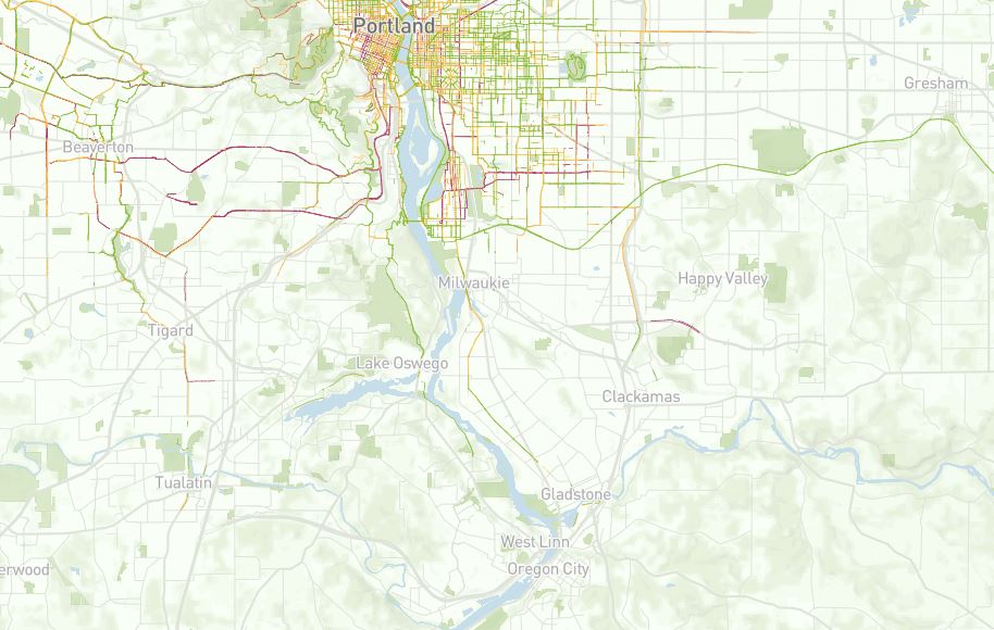
Since I do not feel safe or comfortable enough to bike on Highway 101, which only has “bike share the road” signs, I am not willing to bike on Highway 101. I briefly wrote about bike signage in this 2015 post. I was excited when I found Hammond Truck Road, which is shown in the below Google Maps screenshot, because I thought I found a route to avoid biking on Highway 101. Redwood National Park is the dark green area in the top right corner. Eureka is located south of Crannell. Due to Google Maps showing “This route has restricted usage or private roads,” I contacted Humboldt County staff to clarify whether I could bike on Hammond Tuck Road. As Bob’s reply shows, I would be trespassing if I biked on this road.

The route that you are considering is through private property. These roads have locked gates and are posted with signs indicating no trespassing.

Bob Bronkall, Humboldt County Surveyor

I do not want to embarrass Humboldt County too much. They are at least trying to plan for people who do not drive by providing the Hammond Trail, which I plan to bike on during my vacation. I just wish this trail went all the way to Redwood National Park. Hopefully, this trail will be extended further north someday!

Ray’s Backup Plan

It appears I will be biking less than I wanted during my June vacation. Thankfully, transit services exist between Eureka and Redwood National Park. Redwood Coast Transit operates Route 20 along the below route. While Route 20 does not provide frequent service and only operates on Monday-Saturday, I do not have any safe alternatives to consider. Due to Route 20 ending in Arcata, I may stay in Arcata to avoid having to transfer to another bus to reach Eureka. I wish there was one regional transit provider in this rural area so I could avoid having to transfer!

As this 2022 post shows, I am also concerned about whether the e-bike that I plan to rent will fit on Redwood Coast Transit’s buses. I have not found a transit system in the US that has an entire fleet that can fit e-bikes. While I am waiting for Redwood Coast Transit to confirm that my e-bike rental will not fit on their buses, I assume that I will have no e-bike when I reach Redwood National Park. Despite being used to riding an e-bike, I may rent a non-electric bike so I can take a bike on the bus to Redwood National Park.

Difficulty Finding Redwood National Park Tour

My next barrier after reaching Redwood National Park is finding a group tour. Redwood National Park has limited or no cell and internet services, which is great for disconnecting from social media and emails. I will be traveling alone, so I would prefer to find a group tour to prevent anything bad from happening when traveling alone in an isolated place. While I was excited to find Redwood Adventures, they only offer private tours to groups of at least two people. I emailed them to ask if I can join a larger group or schedule my tour on a less busy weekday. I realize they make more money by preventing single people from scheduling a private tour. I wish I had a girlfriend to go on the tour with me!

https://www.youtube.com/watch?v=gZzJ6C5ujSw&t

Future Blog Post

I may not blog much during my June vacation because I want to enjoy exploring Eureka, Arcata, and Redwood National Park. I also may not have reliable internet access, which I think will be great to help me disconnect from social media and emails. I hope to have time in July to publish posts on how my vacation went. What do you want to read about?

History Is Important When Thinking About The Future

I want to write a quick follow-up post about this Windsor post because I remembered some fascinating historic maps that are in the Petaluma Historical Library and Museum. I visited this museum with a friend today. As the below 1912 map shows, West Windsor used to be served by an agricultural railroad. I need to research whether people were allowed to ride the agricultural train or if the train was only for commercial shipping. Either way, the train no longer exists. I assume car dependency and the shift from railroad shipping to truck shipping caused the trains to no longer exist. I need to research this further to avoid making bad assumptions. I know for certain that Petaluma’s history as being the “Egg Basket of the World” resulted in the need for shipping the eggs. Since this industry is no longer as large in Petaluma, there is no longer much need for shipping eggs.

Regarding how this history relates to the future, the Sonoma-Marin Area Rail Transit (SMART) is working to bring back train service to serve people in Windsor. I am often surprised by how many locals do not know their own local area or state’s history. Since I enjoy studying history, I frequently end up educating them about their own local and state history even though I am not from California. How many locals in Windsor do you think know that West Windsor used to be served by an agricultural railroad?

Photo: Ray Atkinson

While the below 1923 map is not related to Windsor unless you want to count that the train service went to Windsor, it surprised my Unitarian Universalists of Petaluma friend who has lived in California most of his life that Petaluma used to be served by so much train service! Look at all the train routes that used to serve Petaluma! The only remaining train route, which was operated by a different company in 1923, is the route served by SMART. I actually need to research whether the train tracks that SMART currently uses through Petaluma were continuously operated since 1923. I have a feeling that SMART may have restarted service in 2017 on a disused rail line.

Photo: Ray Atkinson

Future Blog Post

Since no one has replied to the questions in my last post, I copied the questions below. While I would enjoy having people comment on my posts, I am mostly writing this blog for my autobiography and for my future wife and kids to read. Assuming I ever get married and have kids, which feels less likely to happen as I am getting older and my future wife is unable to have kids when she reaches menopause, I am looking forward to telling them stories as I reflect on my car-free life. I hope I am not sharing too much. I have been thinking about how I prefer to develop romantic relationships slowly. This likely means that being at the point in my future relationship with my future wife to have kids will take years.

Do you understand the connection between The City at Eye Level and my recent posts about the power of slowing down and its impact on creating robust outdoor in-person social networks? If not, I will keep thinking about how to more clearly write about and show this connection in future blog posts. If so, what other topics do you want me to write about?

Windsor at Eye Level

I was surprised to see that I have not published a “The City at Eye Level” post recently. The link to The City at Eye Level keeps changing, so you can longer download the free book in my previous posts. I will need to update the links. For laypeople reading my blog, I am hoping this post helps you to understand the connection between The City at Eye Level and my recent posts about the power of slowing down and its impact on creating robust in-person social networks. Does this connection make sense after reading this post?

Light Rain Cancels Bike Rental

I was planning to rent bikes from a Windsor bike shop to ride with a new friend who was raised in Windsor, which is an unincorporated town on the northern edge of the North Bay Area. This was my first time visiting Windsor. I have so many new places to explore just in Sonoma County let alone the rest of the Bay Area and California!

While my friend and I were prepared to bike in the light rain, the other renters canceled their rentals and bike tours due to the light rain. The bike shop ended up canceling all the rentals and closing for the day. I have never experienced a bike shop cancel rentals due to light rain. I guess this is a weird welcome to California!

Walk Through Windsor

My friend and I did not want the canceled bike rental to ruin our day. We decided to walk several miles through Windsor instead. Walking instead of driving allowed us to more easily see Windsor at eye level. As the below “MORE BIKES, LESS CARS” banner shows, Windsor is trying to reduce car usage and promote biking. I would include walking in with “MORE BIKES” because there is only so much space on the banner. Unfortunately, my friend and I had to walk single-file through downtown and many other parts of Windsor because the sidewalks are too narrow. Even when the sidewalk is wider, street trees and awning posts prevented us from walking side by side. I saw many people walk directly from their parked cars to their destinations. This does not encourage robust in-person outdoor social networking!

Source: Ray Atkinson

I should clarify that I do not want the street trees to be removed. As this Trees in the Curb Zone Pilot Project from the City of Portland shows, it is possible to replace on-street car parking spaces with trees. BikePortland also published this post about the City of Portland’s project. As my 2015 post from Rijswijk, Netherlands shows, I have been thinking about how to replace on-street car parking spaces with trees for several years. Since my Windsor friend said she does not want to lose car parking for her car and actually feels downtown needs more car parking, do you think rural towns like Windsor will ever have the public and political support to create a project like what Portland created?

Rembrandtkade in Rijswijk, Netherlands in August 2014. Source: Google

I wanted to share the below Spanish version of the above banner because I have never seen a banner with different languages on each side of the banner. I am still using Duolingo to improve my Spanish skills. I even bought a used Spanish textbook from the Windsor Public Library.

Source: Ray Atkinson

Another element that could improve Windsor’s eye-level walking experience and encourage the creation of robust outdoor in-person social networks is the planned SMART regional trail, which will someday connect all the way to the Larkspur Ferry Terminal that provides ferries to San Francisco. I would love to bike from Windsor to the Larkspur Ferry Terminal someday. The first signs of the planned trail and the associated Windsor SMART Station are in the below photo. The SMART Train does not currently serve Windsor, so I rode a Sonoma County bus from Santa Rosa to Windsor. I am excited to see the future of transit-oriented development (TOD) and trail-oriented development! Since trail-oriented development could also be shortened to TOD, I am curious to see what the acronym for trail-oriented development will be.

Source: Ray Atkinson

Future Blog Post

Do you understand the connection between The City at Eye Level and my recent posts about the power of slowing down and its impact on creating robust outdoor in-person social networks? If not, I will keep thinking about how to more clearly write about and show this connection in future blog posts. If so, what other topics do you want me to write about?

Thankful For Nerdy Transportation And Land Use Planning Tours With Friends

I would normally start my Thanksgiving post by writing “Happy Thanksgiving”. Since I frequently use my blog to promote education, I want to use this opportunity to encourage my readers to research the harmful history of Thanksgiving and how this harmful history is still impacting current decisions. While I do not remember questioning why Thanksgiving is celebrated when I grew up in North Carolina, my Native American friends and roommate have helped open my eyes over the last several years to whether Thanksgiving should be celebrated. It is amazing what is not taught in Southern tax-funded K-12 schools. This may have changed since I graduated high school in 2009. I would love to be corrected that Southern tax-funded K-12 schools actually do teach the harmful history of Thanksgiving and how this harmful history is still impacting current decisions.

I should clarify that I am not suggesting that Thanksgiving should not be celebrated. My roommate, who has some Cherokee blood, and I agreed to celebrate Thanksgiving as long as we recognize the harm that was and is still happening to Native Americans. In case this approach is not common for other Native Americans, I want to make the following post welcoming to all readers, including Native Americans who do not celebrate Thanksgiving. I believe this can be accomplished by recognizing the Native American tribes that still reside on the land that was stolen or taken (#Thankstaking appears to be trending as much as “stolen”) by the US government. Due to what I learned from this 2021 article, I also feel it is important to recognize the water that Native American tribes likely have a deep cultural connection to.

We Can Still Be Thankful Without Celebrating Thanksgiving

I believe we can still share what we are thankful for without celebrating Thanksgiving. I have three transportation and land use planning tours to be thankful for. One tour already happened. The other two tours are being planned. I am getting tired and need to be alert when making Thanksgiving dinner with my roommate, so I am going to share the below photos and hope that I return to write more later.

Completed First Tour of Berkeley and Oakland with Solomon Haile

Planning First Tour of Los Angeles with James Rojas

Source: Facebook post

Planning Amtrak Trip with Linn Davis

The second trip that I am planning is with Linn Davis, who lives in Portland, OR. Since we both enjoy riding trains, we are planning an Amtrak trip together sometime in 2023.

Future Blog Post

I have some ideas on how I could write about the two transportation and land use planning tours that I am planning. Since I could write about a range of topics, what would you enjoy reading?

Ray’s Birthday Wish

Tomorrow, September 19, is my birthday. September 19 also happens to be the start of Disability Rights Washington’s Week Without Driving. While Ian Davidson is in Oregon, it appears Week Without Driving is only organized in Washington. World Car Free Day also happens to be this week on September 22. As someone who lives a car-free lifestyle, these challenges feel weird to me. However, I hope they convince other people to temporarily experience car-free living. Will you be participating in Week Without Driving or World Car Free Day?

Ray’s Birthday Wish Is To Feel Safe and Comfortable When Biking, Walking, Hiking, and Riding Transit

As I was biking, walking, and riding the Sonoma-Marin Area Rail Transit (SMART) train from Petaluma yesterday to attend the Mill Valley Fall Arts Festival, I was thinking about my birthday wish. While birthday wishes are probably supposed to be cheap like when I was excited to get a bike as a child, I now desperately want to see the world be improved by creating expensive 8-80 Cities. I should clarify that constructing these 8-80 places will be costly, but humans are already planning to construct expensive places. Behavior change to human-scale transportation planning will be key to successfully constructing 8-80 places.

Since my post includes suburban and rural areas, I wish 8-80 Cities included suburban and rural areas. I believe they are focused on large urban areas. Yes, I realize the 8-80 Cities non-profit organization has limited bandwidth. I am thankful that this organization exists at all to help places with their transformations. While 8-80 Cities may not be involved in the following efforts, I got excited and hopeful as I researched more about all of the regional efforts to create safe and comfortable routes to bike, walk, hike, and ride transit in the Bay Area and Northern California. Since you may not understand the significance of these efforts if you have not experienced the unsafe and uncomfortable existing routes, I want to show you one of these routes that I took yesterday.

Even though I am sharing the below experience from my perspective, 8-80 Cities is focused on making places usable by people from 8 to 80 years old. Due to this, please think about whether an 8-year-old or 80-year-old would feel safe and comfortable biking the route. I have noticed that many experienced adult cyclists say “I” statements when discussing whether a route is safe and comfortable. Yes, the route feels safe and comfortable to an experienced adult cyclist. I want to encourage these cyclists to think about the route from the indicator species’ perspective, which is discussed in the below video. Even better, I would love for these cyclists to invite an 8-year-old or an 80-year-old to ride along the route with them. How much do you want to bet that they will not feel safe and comfortable enough to even accept the ride-along invite?

Source: https://www.youtube.com/watch?v=9Ni32qPrGmM

Biking From Petaluma To SMART’s Novato San Marin Station

The below section of Petaluma Blvd S made me feel so uncomfortable that I ended up getting off my bike and walking. Yes, I have an extreme fear of heights but I may have been able to stay on my bike if there was a trail here. Due to how uncomfortable biking next to automobiles is, I prefer to stay closer to the grass when biking. As the below photo shows, the bike lane was narrowed to provide space for the guardrail and concrete barrier. I decided to cross the road and walk my bike against traffic next to the grass.

I was surprised by how many road cyclists wearing lycra and having no rack for panniers were riding the same route. They kept passing me because I prefer to ride slowly on a hybrid bike that has a rack and panniers. Since they had no bike lock and were only carrying a water bottle, I do not understand their approach to bike touring. I guess they were just biking fast and not planning to lock their bike somewhere to stop for a meal. While I frequently see this approach to biking, it is hard for me to imagine not carrying a lock and planning where to stop for a meal. As I walked my bike down the steep hill (yes, it’s not a very steep hill), two road cyclists asked if I was doing okay. At least they were friendly even when they were biking fast!

Source: Google Maps

I felt much more comfortable at the bottom of the hill when I saw the bike trail, which is the green line south of Mickelson Pumpkin Patch to cross Highway 101. As you compare the zoomed-in map to the overview map, pay attention to the green line south of Mickelson Pumpkin Patch. Since Fire Road is a dead-end road, I would have had to bike back to Petaluma to use a different route to continue south. I Street, which goes by Tara Firma Farms, is a much hillier route than biking on Petaluma Blvd S. The 14.5 miles goes to SMART’s Novato San Marin Station. Since I was out of shape, I took a break from biking and rode the SMART train to the San Rafael Station.

Source: Google Maps
Source: Google Maps

Disappointing Park(ing) Day Weekend in San Rafael

Due to this weekend being Park(ing) Day weekend, I was hoping to see a Park(ing) Day event in Downtown San Rafael’s unused parking spaces. According to the Park(ing) Day website, Hope Housing Of Marin previously participated in Park(ing) Day. It appears there is no Park(ing) Day event in San Rafael this weekend.

Yes, I was excited to see parklets! I just wish there was more bike parking. The only nearby bike rack, which is on the sidewalk, is hidden and blocked by the clothing display. Should I have moved the clothing display and used the bike rack?

Regional Trail Planning Efforts

The rest of my journey to almost Mill Valley was much better than the beginning of my journey. I wrote “almost” because I actually did not make it all the way to the Mill Valley Fall Arts Festival. Since the festival closed at 5pm and I started my journey too late in the morning, I ended up turning around in Corte Madera. While the SMART Pathway does not reach Corte Madera, I biked along it from San Rafael to Larkspur. As the below photo shows, there are plans to extend the SMART Pathway and make it part of the 320-mile, world-class, multi-use rail-to-trail Great Redwood Trail. Yes, Kathy Fitzpatrick, this trail effort appears to be similar to the Columbia River Gorge’s Towns to Trails effort, which I wrote about in this 2021 post.

Future Blog Post

The Great Redwood Trail, which includes the SMART Pathway, is not the only regional trail planning effort in the Bay Area and Northern California. The planned 550-mile (400 miles are already complete) Bay Area Ridge Trail covers some of the route used for the Great Redwood Trail. The Bay Trail is a planned 500-mile walking and cycling path around the entire San Francisco Bay, running through all nine Bay Area counties, 47 cities, and safely across seven toll bridges. Stephan, we should take a future canoe or kayak trip on the San Francisco Bay Water Trail. I still want to explore Minnesota’s Boundary Waters Canoe Area Wilderness with you!

Last and in this case least impressive, Sonoma County Regional Parks created the North Coast Access Trails. I wanted to share this trail system because I want to bike from Petaluma to and along the Pacific Ocean. Unfortunately, this trail system is short and not well connected. Despite this less impressive regional trail system, I am excited to experience and write more about all of these efforts in future posts! Since I want to make my blog interesting to read, is there anything in particular that you want to read about?

Deploying and Rebalancing Dockless Bikeshare and Scootershare to Suburban Areas

I have a love-hate relationship with urban areas. While I love the urban lifestyle, I hate how challenging it has been to expand transportation services to suburban areas. As I wrote in this 2019 post, most of the focus throughout the US to plan for dockless bikeshare and scootershare has been on the largest cities. Even if governments in the Portland region want to expand the focus to suburban areas, are companies willing to expand to suburban areas?

Portland, OR Case Study

East Portland is a suburban area that the Portland Bureau of Transportation (PBOT) acknowledged in its 2018 E-Scooter Findings Report has “historically been underserved by the transportation system”. Since I will be referring to East Portland throughout this case study, please review the below map to make sure you know where East Portland is. As the other below map shows, East Portland has above average numbers of low-income people and people of color.

As the below scooter pilot fee schedule shows, one tool PBOT used to entice companies to deploy and rebalance scooters in East Portland was charging companies less for scooters that were located in East Portland. Companies were charged more for scooters that were located in urban areas like Central City.

To align business practices with Portland’s equity goals, PBOT also required companies to deploy at least 100 scooters or 20 percent of their fleet (whichever is less) in East Portland and offer a low-income fare. Only one company, Bird, complied with the East Portland fleet deployment requirements. Both Lime and Skip deployed below 90 percent of the minimum required scooters on average throughout the pilot. Companies only enrolled 43 Portlanders in the low-income plan. Along with Portland staff observations, this suggests low company performance in aligning business practices with Portland equity goals.

Only one company, Bird, complied with the East Portland fleet deployment requirements.

Source: 2018 E-Scooter Findings Report

While only Bird complied with the East Portland fleet deployment requirements, 243 scooters (9.8 percent of the total fleet for all three companies) were deployed to East Portland. 44,155 trips originated in East Portland during the first pilot period. This demonstrates the demand for additional transportation options. Since East Portland has suburban land uses compared to urban land uses in Central City, I believe trips in East Portland averaged 1.6 miles compared to one mile in Central City because origins and destinations are further apart in East Portland.

Due to it being a pilot program, I am impressed that PBOT actually enforced the rules. Even though this article does not state why Skip has not applied for PBOT’s second pilot program, which starts on April 26, being fined during the first pilot program likely discouraged Skip.

Over the course of the pilot period, PBOT issued two penalties, both to Skip Transport, Inc. One cited failure to meet East Portland fleet deployment requirements, and the other cited failure to meet the citywide deployment requirements outlined in the administrative rule and permit. Penalties were calculated for each day the company was out of compliance after a specified deadline.

Source: 2018 E-Scooter Findings Report

Since only Bird complied with the East Portland fleet deployment requirements during the first pilot, this likely caused PBOT to reduce the requirements for the second pilot. According to this article, “A minimum of 15 percent of a company’s total scooter fleet must be deployed east of I-205 (that’s down from a 20 percent minimum last pilot).” PBOT is also using a new carrot approach during the second pilot to entice companies to deploy scooters in East Portland. Companies will be allowed to increase the number of scooters in their fleet by 35% if they meet or exceed 2-3 trips per scooter per day.

Will suburban cities use Portland’s approach?

I have been asking people that work for suburban cities whether they plan to use Portland’s approach to regulating bikeshare and scootershare companies. Even though I have expressed my concern about them waiting to create regulations, everyone has told me that they plan to wait until Portland launches their second scooter pilot to see whether they need to create regulations. Since I do not want to embarrass any of my contacts, I purposely did not share which suburban cities I have been meeting with about this topic.

As I mentioned in my last post, Milwaukie is planning to allow companies to deploy scooters in Milwaukie soon after Portland launches its second pilot scooter program. I do not have scooter data for Milwaukie and assume scooter riders will use similar infrastructure as cyclists, so I reviewed bike trip data to understand where scooter trips likely will occur. Without any regulations to force companies to deploy and rebalance their scooters in low ridership areas, I predict companies will deploy and rebalance scooters in higher ridership areas. This approach will allow companies to make the most money on their investment.

Since Clackamas Community College’s Harmony campus is located in unincorporated Clackamas County just outside the southeast edge of Milwaukie’s city limit, I am concerned that companies will not supply enough scooters to Harmony campus to make this a reliable transportation service. Milwaukie is working on annexing Harmony campus into the city so Harmony campus will be within the city limit soon. Even when this happens the above map shows that most scooter trips will be in Downtown Milwaukie, which is 3.5 miles west of Harmony campus.

I am focused on Harmony campus because scooters could be used to make the first- and last-mile connection between Harmony campus, Clackamas Middle College and Clackamas Town Center. Since the CCC Xpress Shuttle only goes in a clockwise loop from Harmony campus to Clackamas Town Center, people have asked me to find another transportation service to go from Clackamas Town Center to Harmony campus. The shuttle service is not always frequent and does not operate every day, so people also want a more reliable transportation service from Harmony campus to Clackamas Town Center.

Harmony Campus to Clackamas Town Center

Source: Created by Ray Atkinson using Google Maps

While dock-based scootershare and bikeshare systems are more expensive than dockless scootershare and bikeshare systems, I believe a dock-based system would provide Harmony campus with more reliable transportation service because suburban users would not have to worry about the bikes or scooters staying in urban areas. Since I doubt a dock-based system is a financially feasible option due to lack of public funds (assumes no grant funding), is it possible to entice companies to deploy and rebalance dockless bikes and scooters to Harmony campus without government regulations?

Importance of Trails in Planning for Electric-Assist Dockless Bikeshare and Scootershare

The following post draws on my last post and this 2018 post. As the Portland region prepares for Portland’s second pilot scooter program that starts on April 26th and Milwaukie’s first pilot scooter program that should start this spring, the most used and safest infrastructure for Clackamas County scooter riders likely will prohibit scooters. Since trails are fully separated from automobile traffic, I consider trails to be the safest infrastructure for scooter and bike riders. Unfortunately, many trails in the Portland region prohibit e-scooters and e-bikes. While Jonathan Maus at BikePortland learned that Portland does not enforce this prohibition, the prohibition still creates legal issues for e-scooter and e-bike riders. The following quotes summarize the issues.

“If the City is serious about accomplishing its goals, it needs to act soon to allow at least some level of e-bike and e-scooter access to these areas by non-disabled Portlanders.” – Chris Thomas, Portland lawyer at Thomas, Coon, Newton & Frost

“The Scooter Pilot and your question have had us looking closely at the code and the way people use (and would like to use) our public parks, while maintaining our focus on safety,” – Mark Ross, Public Information Officer at Portland Parks & Recreation

Source: BikePortland

As the below map shows, the region has many existing, planned and conceptual regional trails. While I am still researching the legal issue, I believe the only trail in the region that does not prohibit e-bikes and e-scooters is the Banks-Vernonia Trail, which is not located in Clackamas County. The State Parks Commission amended their rules in 2018 to legally allow e-bikes and scooters on paths and trails managed by the Oregon Parks and Recreation Department (OPRD). According to OPRD’s website, the only trail in the region managed by OPRD is the Banks-Vernonia Trail. While the 40-Mile Loop Trail is listed on this website, I believe local jurisdictions like Portland manage it. Since many jurisdictions manage trails in the region, I hope OPRD and Metro educate all the local jurisdictions about the legal issue. I doubt e-bike and e-scooter users are aware of the legal issue, so we need to have regional legal consistency.

Do riders use trails more than bike lanes in Clackamas County?

Since I live and work in Clackamas County, which is located south of Portland, I focused on what infrastructure Clackamas County scooter and bike riders likely will use to travel. The region’s first scooter pilot program was legally limited to Portland and Portland did not release a map showing scooter rides south of Portland, so I do not have scooter data in Clackamas County yet. Scooter riders typically use the same infrastructure as cyclists, so I analyzed where cyclists currently ride in Clackamas County (left map). While bike lanes exist in Clackamas County, cyclists mostly use trails. In case you are not familiar with the trails, the trail system (right map) shows the same area as the left map. Since I believe all of the regional trails within these maps prohibit e-scooters and e-bikes, how will the jurisdictions that manage these trails approach enforcing their prohibitions? Will they change their policies to allow e-scooters and e-bikes?

Clackamas County Ride Report

Bike trips are mostly along trails. Source: Ride Report

Clackamas County Trails

Solid green lines are existing trails. Source: Metro


Legal Issues in Washington, DC Region

The legal issues are not limited to the Portland region. Since I lived and worked on transportation issues in the DC region last year, I have been following the legal issues in the DC region. NOVA Parks, which owns and operates many trails in Northern Virginia, unanimously amended their rules in March 2019 to allow e-bikes on trails such as the popular Washington and Old Dominion (W&OD) Trail. Across the Potomac River in Maryland, the Montgomery County Planning Board is considering whether to allow e-bikes and e-scooters on county trails. Dockless e-bikeshare and e-scootershare and Capital Bikeshare Plus (e-bikes) already exist in Montgomery County, but people have been riding on county trails even though it is not legal. The DC region has many more jurisdictions, so the legal issues are not resolved yet. Are you seeing similar legal issues where you live?


Regional Planning for Electric-Assist Dockless Bikeshare and Scootershare

Since I believe most of the focus throughout the US to plan for electric-assist dockless bikeshare and scootershare has been on the largest cities, I feel the need to push for more regional planning. My employer, which is Clackamas Community College (CCC), has three campuses that are located in three suburban cities within the Portland region. While I am still surprised to be living car-free and working in America’s suburbia, this experience has provided me with a unique perspective on why regional transportation planning is crucial.

As the below map shows, Portland received responses from throughout the region to its 2018 e-scooter pilot user survey. Even though Portland’s e-scooter pilot was legally limited to Portland, I saw e-scooters as far south as Oregon City. I am not sure whether the companies or their customers were fined for parking scooters outside of Portland. While CCC and jurisdictions within Clackamas County are nervous about allowing e-scooters and e-bikes, is it feasible to ban e-scooters and e-bikes in Clackamas County when people will likely keep riding them south from Portland?

Portland Region Escooter Users Home Zip Code

Source: City of Portland’s February 1, 2019, E-Scooter Users Presentation at Portland State University https://www.slideshare.net/otrec/slideshelf

Through serving on the City of Oregon City’s Transportation Advisory Committee and Clackamas County’s Pedestrian/Bikeway Advisory Committee and talking with residents, I have learned that many Clackamas County residents are resistant to Portland-style transportation thinking and do not want anything to be planned. They believe planning will bring change to their desired small town and country lifestyles, so they have asked me and government staff to stop all planning efforts. Even though I tell residents that e-bikeshare and e-scootershare could reduce traffic congestion and demand for auto parking, which are their concerns, they keep telling me that they only want to widen roads and build more auto parking so they can get places faster by driving. They do not believe me when I tell them that e-bikeshare and e-scootershare have been proven in other places to reduce auto trips and increase non-auto trips.

Portland Scooter Traffic Congestion

Results from Portland’s 2018 E-Scooter Findings Report. Source: City of Portland.

I realize the residents that want to drive likely will not use e-bikeshare and e-scootershare. However, it has been challenging to convince them that other residents like me want to use these shared mobility services. People who want to keep driving will benefit from this because they likely will see reduced traffic congestion and demand for auto parking. As the below map shows, few people currently bike in Clackamas County, which is located south of Portland. This is a major reason why it is hard to convince auto-dependent residents that enough people will use shared mobility services in Clackamas County. I would like to show a similar map for scooter trips, but Portland only released scooter data for trips in Portland.

Ride Report Bike Stress Map Clackamas County

Source: Ride Report https://ride.report/portland

I experienced a similar public backlash when my employer, which was MetroBike, was hired by Montgomery County, MD to expand Capital Bikeshare into suburban areas. Since Capital Bikeshare uses stations and bikes cannot be locked within being docked at a station, Montgomery County could have asked MetroBike to stop the expansion. While some dockless bikeshare and scootershare companies have tried to encourage their customers to park in designated areas, the bikes and scooters are not required to be parked in these areas. This is the main reason why I believe dockless bikeshare and scootershare are coming to Clackamas County whether or not the residents want it. Even if Clackamas County requires the companies to remove their bikes and scooters, bikes and scooters will likely keep coming to Clackamas County until Portland forces the companies to leave the region.

As a planner and someone who wants more transportation choices, I want to be prepared for bikeshare and scootershare. While the public may believe it is not possible to plan for this, I believe it is possible as long as my partners are willing to keep working with me to create and implement a plan. Even though bikeshare and scootershare are quickly evolving, I have found this resource to be useful in my planning effort.

I have only been back in Oregon for eight months, but I am excited to share that I have quickly become a leader in the planning process to prepare the Portland region for bikeshare and scootershare. Since I want to make sure the planning process includes an equity lens and integrates smoothly with other transit services, my partners include TriMet (Portland region’s transit), Metro (Portland region’s MPO), several non-profit equity community groups, and several cities and counties. While Portland has been working with Ride Report to analyze its data, my suburban partners have been evaluating whether and how to include private companies in our planning process.

Portland plans to award permits and launch E-Scooter Pilot 2.0 for a year early this spring and expand Biketown (bikeshare) to include e-bikes this fall when it renews its contract with Motivate, which is owned by Lyft. Since Uber owns JUMP, which provides the bikes for Biketown, it should be interesting to see how Uber and Lyft work together run Biketown. I have never seen two competing companies run the same business together!

Portland Scooter

Next Steps from Portland’s 2018 E-Scooter Findings Report. Source: City of Portland.

Living Car-Free in American Suburb

Yes, you read the title of this post correctly. I am currently living car-free in the American suburb of Oregon City, which is located at the southern edge of the Portland, OR region.

Portland Region Map

Oregon City is located at the southern edge of the Portland region. I live and work in southern Oregon City. Source: AARoads

I will admit that I did not envision living and working in a suburb similar to my childhood hometown of Kannapolis, NC when I moved from Kannapolis to Charlotte in August 2009 to start undergrad at UNC Charlotte. Since I hated feeling forced to drive an automobile for every trip in Kannapolis and loved the freedom of many transportation choices in Charlotte, I never imagined returning to a suburb after graduating from UNC Charlotte. As I hope this post shows you, returning to a suburb may have been the best decision for my career.

While I still prefer living in an urban area and miss living in Arlington, VA’s award-winning Rosslyn-Ballston Corridor, I feel I am making a much bigger difference working in the suburb of Oregon City than I could have made working in a big city. This is mostly because I am the only transportation planner at Clackamas Community College (CCC) and one of the few active transportation planners in Oregon City.

I worked or interned in Charlotte, Philadelphia, Portland (OR), and the DC region, so I am confident that if I worked in a large city I would be in a large transportation department with many staff working on active transportation planning issues. While I am not trying to devalue the work that planners do in big cities, especially since they have to work on more complex issues than I have in Oregon City, how much difference does EACH of these planners have in creating change in their big city?

Since I am an entry-level transportation planner, I keep thinking about how much more difference I am making in Oregon City than I could have made as an entry-level transportation planner among many entry-level transportation planners in a big city. While I have to get permission to do things like apply for grants, I have been given plenty of professional freedom so far to pursue what I feel would be useful for improving multimodal transportation choices at CCC. This also means that I have to be more responsible for the decisions I make because I am the only transportation planner. Since I was micromanaged at a previous job (purposely not giving specifics because I do not want to embarrass a previous employer) and this overwhelmed my supervisor and me, I am thankful my current supervisor is not micromanaging me.

While I wrote earlier how Oregon City is a similar suburb to my childhood hometown of Kannapolis, Oregon City has much better active transportation access to Portland than Kannapolis has to Charlotte. After biking from my home in southern Oregon City to Downtown Oregon City on almost completely connected bike lanes, signed bike routes and sharrows, I can ride on almost completely connected trails all the way to Downtown Portland. The regional version of the below trails map can be found here. I actually helped create this map during my internship at Oregon Metro.

Portland to Oregon City Trails Map

Regional trails between Oregon City and Downtown Portland. Source: Oregon Metro

The below map shows most of the bike infrastructure between Oregon City and Downtown Portland. Since Portland’s famous neighborhood greenways and Oregon City’s signed bike routes and sharrows aren’t shown at this zoom level, I wanted to note that this is missing from the below map.

Portland to Oregon City Bike Map

Bike infrastructure between Oregon City and Downtown Portland. Source: Google Maps

Unless I rarely wanted to visit Charlotte or spend lots of time and money on transferring between multiple transit systems in the Charlotte region (I can take unlimited trips on TriMet’s light rail lines and buses throughout the Portland region for $5/day), I could not have lived car-free in Kannapolis. While the Carolina Thread Trail is working to connect trails throughout the Charlotte region and I volunteered to help create the Carolina Thread Trail Map, it is not possible today to use trails or any other bike infrastructure to bike between Downtown Kannapolis and Uptown Charlotte. Since Charlotte’s bike lanes, signed bike routes and sharrows are not shown at this zoom level, I wanted to note that this is missing from the below map.

Charlotte to Kannapolis Bike Map

Bike infrastructure between Uptown Charlotte and Downtown Kannapolis. Source: Google Maps

Oregon City has good biking and transit access to Portland, so I have been able to visit Portland frequently without driving. While some people in Oregon City have suggested I should buy a car so I can travel quicker, owning and maintaining a car is expensive. Plus, my job literally involves helping people to reduce car dependency. I can currently motivate people to reduce car dependency by telling them that it is possible to live car-free in a suburb like Oregon City because I live car-free here. How would they react if I told them I gave up and purchased a car for the first time in my life?

While I live car-free in my personal life, I cannot reach all my work trips by walking, biking and riding transit. Since I did not want to buy a car for work trips, my supervisor helped me reserve the below hybrid electric car, which CCC owns. This car is only available during the summer term because students learn how to reconstruct the car during other terms. Due to this, I have had to use expensive transportation network companies like Uber and Lyft to travel for work trips during the rest of the year. Even though I was nervous about whether my supervisor would support my car-free lifestyle, he has been very supportive.

I have so far driven the hybrid electric car to and from the Clackamas County Coordinating Committee (C4) Meeting near Mt Hood. Since this was the first time I drove after moving back to Oregon and I didn’t drive much when I lived in Virginia, I had to adjust to driving again. I have always been a slow driver, but Oregon drivers have been proven to be among the nation’s slowest drivers so I fit in.

2018-06-13 08.57.34

Hybrid electric car provided for work trips. Photo: Ray Atkinson

As my below Instagram post shows, the C4 Meeting provided me with good insights into Clackamas County’s transportation priorities. Unfortunately for my work to reduce car dependency, widening I-205 is definitely the top priority. Oregon DOT (ODOT), which presented about the I-205 toll and widening project during the C4 Meeting, has been trying to get support for widening I-205 by saying this will reduce traffic congestion. While traffic congestion may be reduced in the short-term, induced demand has shown that widening highways never reduced traffic congestion in the long-term. This is why ODOT needs to use the I-205 toll revenue to fund active transportation projects, which have been proven to reduce traffic congestion on highways. If ODOT is looking for an existing program to review, I recommend the I-66 Commuter Choice Program because revenue from the I-66 toll in Northern Virginia is directly funding active transportation projects in Northern Virginia.

I have not decided what my next blog post will be about, but it will probably be something about what I am experiencing in Oregon. Thank you for reading my blog!

First Impressions of Portland

I moved to Portland, Oregon on September 13, so I have lived here for over a week.  Before classes start on September 29, which is when I will need to focus much more time on studying and not writing my blog, I wanted to take a moment to share my first impressions of Portland. Since this is a transportation blog, I will start by comparing Portland and Charlotte’s transportation systems. I will conclude this post by discussing a few non-transportation topics that have impacted my transition to my new life in Portland.

Portland’s transportation system is much better than Charlotte’s transportation system. I rode transit, biked and walked in Charlotte and have been riding transit, biking and walking in Portland so will discuss these three modes. The main reason I love using transit in Portland is because TriMet, Portland’s regional transit system, is reliable. I downloaded one of the 50 or so third-party apps that were developed using TriMet’s open data. According to this article, “Rather than pay an in-house programmer, Oregon’s largest transit agency was the first in the nation to set its schedule and arrival data loose for outside developers to do with it what they may.” The screenshots show the PDX Bus app, which has real-time arrival information and other information. The real-time arrival information is very accurate, so I know exactly when I need to be at the bus stop.

pdxbus appHow does the Charlotte Area Transit System (CATS) compare to TriMet? Take a look at the lack of diverse CATS transit apps. I’m assuming CATS has so few transit apps because it does not provide open source data to third-party developers who could create a diversity of apps. In addition to not having a diversity of apps, CATS only offers approximate arrival information instead of real-time arrival information. Hopefully someday CATS will provide real-time arrival information with a diversity of apps to choose from.

My roommate, who is from Kansas and also an incoming MURP interested in transportation planning, and I live next to a neighborhood greenway so we constantly see cyclists. The below video, which was produced in 2010, shows what a neighborhood greenway is. I had never seen a neighborhood greenway in the United States before moving to Portland so assumed a neighborhood greenway was like an off-road greenway. While the neighborhood greenways have many benefits, which are discussed in the video, my roommate and I have experienced at least one issue while using them. The main issue my roommate and I have had with the neighborhood greenway next to our apartment is crossing busy intersections. In addition to the cross street having so many automobiles, many of the cross streets have sight issues because of on-street parking. We have to move far enough into the intersection to see past the parked automobiles. Due to this issue, we have considered avoiding neighborhood greenways and biking on arterials with stop lights so the stop lights stop cross traffic.

Our apartment is so close to everything that we have actually been walking to the grocery store, restaurants, and bars. Since we only live about two miles from downtown Portland, there are sidewalks and crosswalks with pedestrian signals everywhere. Our neighborhood feels very similar to the NoDa neighborhood in Charlotte because it has concert and other ads posted on light poles, artistic graffiti drawn on buildings, and there are bars everywhere. I’m definitely not used to living in a neighborhood like this. However, I am growing to appreciate my new environment.

One area of my new environment that I am struggling to adapt to is the bar scene. While I knew before I moved to Portland that Portlanders and graduate students at any university love drinking alcohol, I am still out of my comfort zone. I almost never drank alcohol in North Carolina so have no idea what to order when I go to the bar with my roommate or other people. To make matters worse, the second year MURPs have organized bar socials this Friday and Saturday for them to meet the incoming MURPs. Besides when I attended graduate club meetings at UNC Charlotte, I never went to a bar so am nervous about how I will fit in with so many graduate students that probably have been drinking alcohol for years. It feels like Greek Life to me, which I avoided at UNC Charlotte, because I feel fraternity members have to drink alcohol to fit in with their brothers. Thankfully, my roommate and several other MURPs have told me they can teach me about alcohol. While I am open to learning, I haven’t enjoyed drinking alcohol so far. I prefer drinking milk, lemonade, orange juice, sweet tea, smoothies, and many other non-alcoholic drinks. I enjoy that nonalcoholic drinks are cheaper and most have free refills. I am also nervous about getting drunk. Since I have never been drunk, I don’t know my drinking limit. I have seen people get drunk before and it didn’t look enjoyable so I would prefer not ever getting drunk. In case you are wondering, I didn’t come to Portland for the famous beer and bars. I came to Portland to study the famous urban and regional planning.

Unlike UNC Charlotte’s main campus, which is located about ten miles from uptown Charlotte, Portland State University is located in downtown Portland. One of the biggest things I have noticed with attending school in downtown Portland is panhandling. While uptown Charlotte and downtown Portland have about the same amount of panhandling, I rarely went to uptown Charlotte so didn’t experience panhandling on a daily basis. I rarely experience panhandling outside of downtown Portland. Now that I have classes in downtown Portland almost every day, I will have people asking me for money every time I go to downtown Portland. Experiencing panhandling on a nearly daily basis gets depressing, especially when the panhandlers say things to put me down for not giving them any money.

While Portland’s transportation system is much better than Charlotte’s transportation system, Portland can still improve its transportation system. I am looking forward to studying urban and regional planning, which includes how to approach panhandling, more than drinking alcohol. Since classes start on September 29, my next post will probably be shorter but I hope to continue writing my blog during the school year.