Ray Has Driver’s License Again

I never thought I would be excited and relieved to share through my blog that I can drive a car because I have resisted driving for longer than my blog has existed. I passed the North Carolina DMV road test on my first attempt today, so I have a driver’s license again. Thanks to my caring and supportive parents, twin sister, her boyfriend, and many friends for helping me pass the test. I do not own a car, so I drove my sister’s car. I did not plan to learn how to drive again until my Tennessee driver’s license was revoked last month. I was surprised to be given a North Carolina photo ID. My Tennessee driver’s license was only a year old, so it would not have expired for seven years. While most people get a new driver’s license when they move to a new state, I did not need to get a driver’s license in North Carolina because I only plan to stay here temporarily. I honestly prioritized voting in the swing state of North Carolina too much.

Since the last time that I had driven a car was a few times in Oregon before the COVID restriction, and I had not driven a car regularly for over ten years, which is when I used to commute from Kannapolis to Charlotte for internships, I was unsure whether I still knew how to drive a car. I learned plenty about my body over the last month. I almost did not even pursue getting my driver’s license again because I did not want to experience the extreme anxiety that I knew would happen when I drove. I decided to pursue getting my driver’s license again when I saw many transportation planning jobs require a driver’s license, and many potential dates reject me. Yes, I probably should not be trying to date in Kannapolis when my car-free lifestyle is too extreme for a car-dependent city.

Due to how few car-free census tracks exist, I want to be open to the possibility of using my driving skills to be more attractive to potential dates wherever I move next. This assumes achieving my Motherload documentary dream is not feasible. Since friends keep telling me not to change my identity to fit what my dates want me to do, I am struggling with whether to continue getting comfortable with driving or return to my car-free lifestyle. My dad made a good point last weekend that I could start saying “sustainable transportation lifestyle” instead of “car-free lifestyle” to avoid scaring away potential employers and dates who may not be open to my car-free lifestyle. The definition of sustainable transportation likely varies from person to person, so this would provide me with more flexibility when employers and women inquire about my lifestyle.

Unfortunately, the US has very few majority car-free census tracks. Source: https://www.liberallandscape.org/2021/09/29/the-geography-of-carfree-households-in-the-united-states/

Thankfully, I did not experience a panic attack during the DMV road test because my mindfulness skills are improving. I focused on taking deep breaths and being present in the moment instead of worrying about what had happened or could happen. I almost lost focus when I did the three-point turn incorrectly. I saw grass in the rear-view camera, so I thought I had backed up too far. I ended up making a five-point turn when I did not want to go into the grass in front of me. Instead of allowing this to prevent me from passing, I stayed focused on continuing to make complete stops at intersections. Due to how it is legal for cyclists to do rolling stops in Oregon, I found it tough to break this habit as I prepared for the test. I had to quickly develop a new habit of coming to complete stops.

Future Blog Post

I want to return to my usual blogging style at some point. I miss blogging about cities using The City at Eye Level approach.

Ray’s Birthday Wish Is Continued Self-Improvement: Mindfulness

I have been thinking of ways to take better care of myself that do not require me to wait until moving to a healthier city. I am not willing to let my childhood home’s Walk Score of zero prevent me from being successful with my addiction recovery. As you may remember, I have been trying to prioritize self-care this year. I was making good progress in creating a daily habit of reading the book that Brandie sent me until I experienced emotional traumas in Memphis during the week of May 12. The bookmark in this book is still on the pages that show May 13-16. Since my blog is about car dependency, I feel comfortable publicly sharing that my car-free lifestyle caused dates and friends at that time to stop communicating with me.

Improving Mindfulness Skills

I found some yoga and meditation studios near my home in Kannapolis, NC. I miss many of my friends, so I also want to start new friendships by participating in activities at these studios. While none of them are within easy walking, biking, or transit distance, I still plan to check them out. I feel awkward depending on people for rides when I used to transport myself. I realize yoga and meditation are two approaches to mindfulness. I am trying to take a holistic approach to improving my mindfulness skills. Do you have any mindfulness tips? What is your favorite type of mindfulness?

Future Blog Post

I want to return to my usual blogging style at some point. I miss blogging about cities using The City at Eye Level approach.

Remembering Legendary Kannapolis Historian Norris Dearmon and Happy 10th Anniversary to My Blog!

I was originally planning to write a quick memorial post about legendary Kannapolis, NC historian Norris Dearmon, who died yesterday at 100 years old. He had a long and impactful life. Since I volunteered with his son, Eric Dearmon, I am keeping him in my thoughts as I remember his father. As the below photo shows, I was fortunate enough to learn from Norris while I was creating my senior exit project at Northwest Cabarrus High School in 2009. My project was titled the Impact of the North Carolina Research Campus on Kannapolis. Norris and I shared our love and passion for history and maps. Mrs. Andersen, I know you read my blog. Thank you for being my senior exit project advisor!

Ray looking at a historic photo of Kannapolis, NC from the mid-1900s with legendary historian Norris Dearmon at the Kannapolis Library in 2009 for Ray’s high school senior exit project

While I have not been blogging long enough to have included my high school experiences when they happened, WordPress surprised me with the below Happy 10-Year Anniversary when I logged in tonight. I made it to 10 years! On the 10-year anniversary of my blog, I think Norris would have been proud of how I have continued to promote the value of learning history.

As I write this post in Petaluma, I find it interesting to reflect on the fact that I had not even heard of Petaluma when I started my blog in 2014. While I pride myself on being a geographer who knows where places are located, I also did not even know the location of Petaluma within California when I lived in Oregon. My blog has been through an international geographic journey. I am excited to visit and blog about more places around the world!

I try not to be jealous, but I think it would have been fun to celebrate this achievement in a similar fashion to how BikePortland’s supporters celebrated the 10-year anniversary of BikePortland.org in 2015. Yes, I realize BikePortland has more readers and active engagement than my blog. We have different blogging styles. I prefer using my blog to write my autobiography for me and my future family. Since I am very curious about how my future wife and kids will react to my blog, I hope that I have the opportunity to get married and have kids.

Future Blog Post

Here is to the next 10 years of my blog! What is your favorite post from my first 10 years of blogging?

Kannapolis is Changing at Eye Level

“Kannapolis is Changing at Eye Level” is a reference to “The City at Eye Level”. As you may know, I was raised in Kannapolis, NC. I lived in Kannapolis from when I was born in 1990 to when I moved to Charlotte in 2009 to attend UNC Charlotte. I also lived in Kannapolis from 2013-14 between graduating from UNC Charlotte and starting my Transportation Planning Internship at Toole Design Group in the Washington, DC region. While I did not plan to visit Kannapolis in 2020, the coronavirus forced me to work remotely and only fly within the US. Since spas inside resorts were closed due to the coronavirus, I decided to visit Kannapolis during my 24-day workation.

As the below 2020 photo (right) shows, the reconstruction of West Avenue in Downtown Kannapolis was completed in time for me to check it out during my visit. While I wish Kannapolis planners had constructed back-in parking because it is safer for all road users than front-in parking, I am impressed with how Kannapolis planners revitalized the deteriorating West Avenue. Since I grew up in Kannapolis, I remember how West Avenue looked in the 2017 Google Street View, which is on the left in the below photos.

Before (2017) and after (2020) West Avenue in Kannapolis. Source: Google Street View (2017)

Many people are unfamiliar with what back-in parking is and the benefits of this parking for all road users. Due to this, I wanted to share how Charlotte, NC has been using back-in parking before I continue to share about the changes to West Avenue. For readers unfamiliar with where Kannapolis is located, Kannapolis is a suburb of Charlotte. While I realize the big city usually implements new things before the suburbs do, I was hopeful that Kannapolis would implement back-in parking when it redesigned West Avenue because Charlotte has been using back-in parking for several years.

Instructions for Back-In Parking in Charlotte, NC. Source: City of Charlotte, NC
Source: City of Charlotte, NC

Since my dad needs me to help him move things around the house before I fly from Charlotte to Minneapolis today, I am going to write the rest of this post later. I took about 50 photos of the West Avenue changes yesterday. I plan to share many of these photos when I have more time to finish this post. In case Kannapolis planners read my blog, I wanted to thank you for making the changes to West Avenue. While I wish back-in parking was constructed, I enjoyed most of the changes so great work on revitalizing Downtown Kannapolis!

Living Car-Free in American Suburb

Yes, you read the title of this post correctly. I am currently living car-free in the American suburb of Oregon City, which is located at the southern edge of the Portland, OR region.

Portland Region Map

Oregon City is located at the southern edge of the Portland region. I live and work in southern Oregon City. Source: AARoads

I will admit that I did not envision living and working in a suburb similar to my childhood hometown of Kannapolis, NC when I moved from Kannapolis to Charlotte in August 2009 to start undergrad at UNC Charlotte. Since I hated feeling forced to drive an automobile for every trip in Kannapolis and loved the freedom of many transportation choices in Charlotte, I never imagined returning to a suburb after graduating from UNC Charlotte. As I hope this post shows you, returning to a suburb may have been the best decision for my career.

While I still prefer living in an urban area and miss living in Arlington, VA’s award-winning Rosslyn-Ballston Corridor, I feel I am making a much bigger difference working in the suburb of Oregon City than I could have made working in a big city. This is mostly because I am the only transportation planner at Clackamas Community College (CCC) and one of the few active transportation planners in Oregon City.

I worked or interned in Charlotte, Philadelphia, Portland (OR), and the DC region, so I am confident that if I worked in a large city I would be in a large transportation department with many staff working on active transportation planning issues. While I am not trying to devalue the work that planners do in big cities, especially since they have to work on more complex issues than I have in Oregon City, how much difference does EACH of these planners have in creating change in their big city?

Since I am an entry-level transportation planner, I keep thinking about how much more difference I am making in Oregon City than I could have made as an entry-level transportation planner among many entry-level transportation planners in a big city. While I have to get permission to do things like apply for grants, I have been given plenty of professional freedom so far to pursue what I feel would be useful for improving multimodal transportation choices at CCC. This also means that I have to be more responsible for the decisions I make because I am the only transportation planner. Since I was micromanaged at a previous job (purposely not giving specifics because I do not want to embarrass a previous employer) and this overwhelmed my supervisor and me, I am thankful my current supervisor is not micromanaging me.

While I wrote earlier how Oregon City is a similar suburb to my childhood hometown of Kannapolis, Oregon City has much better active transportation access to Portland than Kannapolis has to Charlotte. After biking from my home in southern Oregon City to Downtown Oregon City on almost completely connected bike lanes, signed bike routes and sharrows, I can ride on almost completely connected trails all the way to Downtown Portland. The regional version of the below trails map can be found here. I actually helped create this map during my internship at Oregon Metro.

Portland to Oregon City Trails Map

Regional trails between Oregon City and Downtown Portland. Source: Oregon Metro

The below map shows most of the bike infrastructure between Oregon City and Downtown Portland. Since Portland’s famous neighborhood greenways and Oregon City’s signed bike routes and sharrows aren’t shown at this zoom level, I wanted to note that this is missing from the below map.

Portland to Oregon City Bike Map

Bike infrastructure between Oregon City and Downtown Portland. Source: Google Maps

Unless I rarely wanted to visit Charlotte or spend lots of time and money on transferring between multiple transit systems in the Charlotte region (I can take unlimited trips on TriMet’s light rail lines and buses throughout the Portland region for $5/day), I could not have lived car-free in Kannapolis. While the Carolina Thread Trail is working to connect trails throughout the Charlotte region and I volunteered to help create the Carolina Thread Trail Map, it is not possible today to use trails or any other bike infrastructure to bike between Downtown Kannapolis and Uptown Charlotte. Since Charlotte’s bike lanes, signed bike routes and sharrows are not shown at this zoom level, I wanted to note that this is missing from the below map.

Charlotte to Kannapolis Bike Map

Bike infrastructure between Uptown Charlotte and Downtown Kannapolis. Source: Google Maps

Oregon City has good biking and transit access to Portland, so I have been able to visit Portland frequently without driving. While some people in Oregon City have suggested I should buy a car so I can travel quicker, owning and maintaining a car is expensive. Plus, my job literally involves helping people to reduce car dependency. I can currently motivate people to reduce car dependency by telling them that it is possible to live car-free in a suburb like Oregon City because I live car-free here. How would they react if I told them I gave up and purchased a car for the first time in my life?

While I live car-free in my personal life, I cannot reach all my work trips by walking, biking and riding transit. Since I did not want to buy a car for work trips, my supervisor helped me reserve the below hybrid electric car, which CCC owns. This car is only available during the summer term because students learn how to reconstruct the car during other terms. Due to this, I have had to use expensive transportation network companies like Uber and Lyft to travel for work trips during the rest of the year. Even though I was nervous about whether my supervisor would support my car-free lifestyle, he has been very supportive.

I have so far driven the hybrid electric car to and from the Clackamas County Coordinating Committee (C4) Meeting near Mt Hood. Since this was the first time I drove after moving back to Oregon and I didn’t drive much when I lived in Virginia, I had to adjust to driving again. I have always been a slow driver, but Oregon drivers have been proven to be among the nation’s slowest drivers so I fit in.

2018-06-13 08.57.34

Hybrid electric car provided for work trips. Photo: Ray Atkinson

As my below Instagram post shows, the C4 Meeting provided me with good insights into Clackamas County’s transportation priorities. Unfortunately for my work to reduce car dependency, widening I-205 is definitely the top priority. Oregon DOT (ODOT), which presented about the I-205 toll and widening project during the C4 Meeting, has been trying to get support for widening I-205 by saying this will reduce traffic congestion. While traffic congestion may be reduced in the short-term, induced demand has shown that widening highways never reduced traffic congestion in the long-term. This is why ODOT needs to use the I-205 toll revenue to fund active transportation projects, which have been proven to reduce traffic congestion on highways. If ODOT is looking for an existing program to review, I recommend the I-66 Commuter Choice Program because revenue from the I-66 toll in Northern Virginia is directly funding active transportation projects in Northern Virginia.

I have not decided what my next blog post will be about, but it will probably be something about what I am experiencing in Oregon. Thank you for reading my blog!

Advocating for Automobiles to Advocating for People

Before I started at UNC Charlotte, I actually advocated for automobiles because I advocated for NC 3 to be widened between Mooresville and Kannapolis. Even though I can’t see your face or hear your reaction, many of my college friends have been surprised to learn that I haven’t always advocated for people. When I say I now advocate for people, this includes people who drive automobiles. This article discusses how it is possible to advocate for motorists, bicyclists, pedestrians, and transit users all at the same time. The below photo shows one example because First Avenue in New York City was redesigned to accommodate more than just motorists. As the after graphic demonstrates, motorists, bicyclists and transit users all have dedicated space on the road.

First Avenue in New York City

First Avenue in New York City

Even though the below photo may not be of First Avenue, it shows how pedestrians benefit from the road redesign because the crossing distance is shorter. Before the redesign, pedestrians didn’t have a pedestrian refuge island.

Pedestrians benefit

Motorists benefit from the redesign because there are left-turn pockets, which reduced the amount of automobile traffic delay on First Avenue. “No doubt many factors were involved, but a DOT spokesperson tells CityLab that the steady traffic flow was largely the result of adding left-turn pockets. In the old street configurations, cars turned left from a general traffic lane; in the new one, they merged into a left-turn slot beside the protected bike lane (below, an example from 8th and 23rd). This design has two key advantages: first, traffic doesn’t have to slow down until the left turn is complete, and second, drivers have an easier time seeing bike riders coming up beside them.”

Motorist benefits

Returning to how I advocated for motorists. I actually have proof of how I advocated for motorists through this Salisbury Post article from the week of January 23, 2009 (original article link was lost so article date is wrong). Hugh Fisher, who I am good friends with today, wrote the following in the article.

Not everyone was opposed to the idea of a wider N.C. 3. Ray Atkinson lives about a mile off of the highway.
“I think it’s good to plan for growth,” Atkinson said. The N.C. Research Campus in Kannapolis would benefit from the proposed improvements, he added.

Since NC 3 between Mooresville and Kannapolis goes through low density land uses like farm land, I wouldn’t advocate for NC 3 to be widened today. Widening NC 3 where there is low density land use would promote sprawl. I may be open to supporting widening NC 3 if the area becomes more dense, but hopefully the area will only become more dense after fully developing the high density land uses within the city limits of Mooresville and Kannapolis. The following shows the article with a photo of me looking at maps of the options for NC 3.

Kannapolis Citizen article from January 28, 2009

Kannapolis Citizen article from the week of January 28, 2009

I said the statements during my senior year at Northwest Cabarrus High School and just a semester before I started at UNC Charlotte. What do you think I would say today with the below option as one of the choices?

Option B calls for a slightly higher residential zoning density and would allow more light commercial development in selected “neighborhood centers.”
That plan also calls for expanding N.C. 3 to a four-lane “rural parkway” designed to remain scenic, with a grassy median and no sidewalks. There would be a separate path alongside the road for pedestrians and cyclists.

If the interview were today, I believe I would have expressed appreciation for including “a separate path alongside the road for pedestrians and cyclists.” This change in perception can most likely be attributed to my car-light lifestyle while attending UNC Charlotte. Once I realized the benefits of providing people with transportation choices and seeing all the negative outcomes of driving an automobile, I co-founded and was president of the UNC Charlotte Cyclists Club. I find it amazing how much living car-light impacted my future education and career. When I started at UNC Charlotte, I didn’t even think about attending the University of Oregon or Portland State University. Becoming a sustainable transportation planner wasn’t even on my horizon before I started at UNC Charlotte.

One career path that did remain consistent throughout my life was my passion for geography. I have always enjoyed reading and creating maps. However, how I use and create maps have changed over the course of my life so far. Even though I was interested in geography before I started at UNC Charlotte, I was more interested in becoming a meteorologist just a few years before I refocused on becoming a planner. The below photo shows what my 4th grade teacher gave me in 2001, which shows proof of my interest in meteorology. Meteorologists and planners both use maps so this is where the careers are similar.

Due to possible confusion with the title of this post, I want to discuss the significance of why I chose to use the word “automobiles” in the the title. Since automobiles are not people, why not replace automobiles with motorists? I purposely wrote automobiles instead of motorists to show the impact of planning for automobiles instead of people. The below photo shows how this difference in thinking makes a huge difference in how our world has been planned. How many people are in the top and bottom halves of the photo? As you count the number of people, please remember motorists drive automobiles. I differentiate between automobiles and motorists because you can’t see motorists from outside their automobiles. If you counted automobiles, please recount the number of people. Do you see the difference?

If you plan cities for cars and traffic, you get cars and traffic. If you plan for people and places, you get people and places.

Another option for the title is “Advocating for Motorists to Advocating for People”. Since motorists are people, what is the difference between advocating for motorists and people?  The difference lies in the fact that not all people are motorists. In order to plan for people, planners need to plan for all modes of transportation and not just motorists. Surprisingly, I haven’t always thought this.

Car Dependence to Car Free

I moved from Kannapolis, NC to Silver Spring, MD on June 29. I wanted to write a blog post before arriving in Silver Spring about how I expected my life to change as I went from being dependent on my parents’ car for nearly every trip to car-free for every trip. Since I had to pack, keep up with emails and sleep at least a few hours per night, I ended up not having time to write this blog post.

Now that I am in Silver Spring, I want to reflect on my experience so far with living car free. In order to check how I am handling living car-free, I wanted to hear whether I would ever say, “where is my parents’ car when I needed it?” I haven’t said this once. Instead, I have asked, “why are people driving an automobile in a region that has good (could be improved in many ways) walking, biking and transit infrastructure?” When I asked this, I actually looked at my driver’s license and noticed it expires on September 19, 2016. This will occur after I have graduated from Portland State University and hopefully have started a full-time job. If I find a job in a location where I don’t need to drive an automobile, which I am determined to find, I am seriously considering not renewing my driver’s license. For the reasons I have discussed in previous posts and many more reasons that I haven’t written about yet, I would never have thought this in Kannapolis. However, since I have been involved with bike planning meetings in Kannapolis, I would like to say that Kannapolis recognizes that people are asking for healthy and liveable communities so it is working hard to make Kannapolis more bike friendly. I look forward to someday returning to Kannapolis and biking safely to do all my trips. I am confident this day will come before I die.

Since the walking, biking and transit infrastructure is reasonable in the DC region, I have been walking, biking and riding transit for all my trips. This includes biking to work, walking to lunch, biking to the grocery store, biking and riding transit to downtown DC, moving from home to home by bike, and many other trips. While I can write an essay on my experience with each of these trips, I decided to focus this post on just a few aspects of my experience with biking over 50 miles in one day throughout the DC region. I included comparisons to the Charlotte region and the Netherlands.

What better way to explore the DC region than by bicycle! As the below map of my July 4 ride shows, I have biked over 50 miles throughout the DC region in a single day. I did another 50+ mile ride on July 20. Due to my cell phone dying both times, which I have been using for directions and counting mileage (both need constant use of GPS and 3G), I don’t have an exact number of miles. Having my cell phone die also brings up a very serious safety issue for me because I need a cell phone to call my cousin, who actually lives in DC, and police. I am currently looking at purchasing another battery and/or a bike computer so I can do everything I want to do and not risk my safety.

Ray's 50+ mile bike ride on July 4

Ray’s 50+ mile bike ride on July 4

Continuing with how I biked over 50 miles. The last time I biked over 50 miles in one day was when I was in the Netherlands during the summer of 2012. I have never biked over 50 miles in one day in the Charlotte region. While the bike infrastructure is slowly improving in the Charlotte region, which one can see with the Charlotte City Council’s vote to build the Cross-Charlotte Trail, not having biked at least 50 miles in one day in the Charlotte region informs me how terrible the bike infrastructure is in the Charlotte region. The main reasons I biked over 50 miles in the DC region was because the trail networks are well connected and last for miles and many roads like Beach Drive have slow-speed traffic and many cyclists to bike with.

Sections of Beach Drive are closed to motor vehicles on the weekends and holidays

Sections of Beach Drive in Rock Creek Park are closed to motor vehicles on the weekends and holidays

I start riding on these trails and roads and forget how long I have been riding. It makes it even easier to ride for miles when I ride alongside a stranger or two as we discuss our histories, why we love cycling, how we would improve cycling in the DC region, and above all motivate each other to keep going. I can’t wait to do this with my future classmates and coworkers as we ride thousands of miles together!

I plan to bike over 50 miles every weekend I am in the DC region and continue biking over 50 miles per day as often as I can once I arrive in Portland. While the DC region has a great transit system, I find biking to be the best way to explore the DC region because I am not restricted to exploring where the transit system goes, it costs less to bike, biking is faster than walking, I enjoy getting lost in a neighborhood I have never been in before, I can stop where ever I want, I enjoy watching people as they move and interact, people on transit are usually glued to their cell phones or sleeping, and many other reasons.

Since my parents, especially my mom, have been asking me what I am doing at my internship, I will provide a quick overview. Even though my title is Transportation Planning Intern at Toole Design Group, which I thought would have involved reading and writing transportation planning documents and less GIS analysis, all my work has been GIS analysis. In addition, the path to receiving my current internship was unlike any of my other internships and I have had several internships. Without writing another essay, I will just say that I applied for the internship in March after being recommended by a current employee in Toole Design Group’s Boston office for a full-time GIS Analyst position. I know the Boston employee from serving on the Association of Pedestrian and Bicycle Professionals (APBP)’s Young Professionals Committee. I ended up applying for both the GIS Analyst and Transportation Planning Intern positions.

Continuing with what I am doing at my internship. After reading the internship responsibilities in March, I was informed what my internship responsibilities were going to be in June. Since I am currently working on a real project from the start of the project until I have to leave for Portland (short stop in Kannapolis), it was worth the wait to find out what my internship responsibilities were going to be. I have been using ArcGIS 10.2 and Google Earth so far to determine where 200 bike share stations should be located for Philadelphia’s bike share program, which will launch in 2015. I have been communicating with Toole Design Group staff in Portland, OR and Silver Spring, MD and City of Philadelphia staff. One of the things we communicated about was requesting data from the CyclePhilly App, which is shown below. I have never had an internship as fast-paced or involve as many people as this internship is. With the help of my supervisors, I have felt prepared for every challenge and am ready for what my next challenge brings!

CyclePhilly App’s first six weeks reveals where people in the Philadelphia region ride

CyclePhilly App’s first six weeks reveals where people in the Philadelphia region ride

I want to write about many more aspects of my transition from car dependence to car-free, but will save these aspects for future posts and in-person discussions. Since I am interning full-time, taking time to eat so I can try to gain weight while biking, doing all the house chores (living alone at the moment), biking countless amount of miles per day, and trying to get enough sleep per night, I am not sure when my next post will be. I am writing new draft posts every day when I see, hear, touch, smell, and taste something I want to write about. I have so far written nearly 50 draft posts, which are ready to be fully written so definitely have plenty to photograph, research and write about. Yes, my next post should have fewer words and more photos.

Ray’s Redesign to Create Bike Connection

Kannapolis has been talking about the proposed widening of Mooresville Road, which includes wider outside travel lanes for cyclists, and proposed road diet and buffered bike lanes on Loop Road for several months. However, very few people have been talking about the missing bike connection between these two projects. I hope this blog post will provide Kannapolis and NCDOT with a potential redesign to safely and conveniently connect both projects. Before I discuss my redesign, I want to make sure everyone knows where the missing bike connection is located in Kannapolis. I also want to provide a short overview of who owns Loop Road and Mooresville Road because I feel this has impacted both projects.

Where is the missing bike connection?

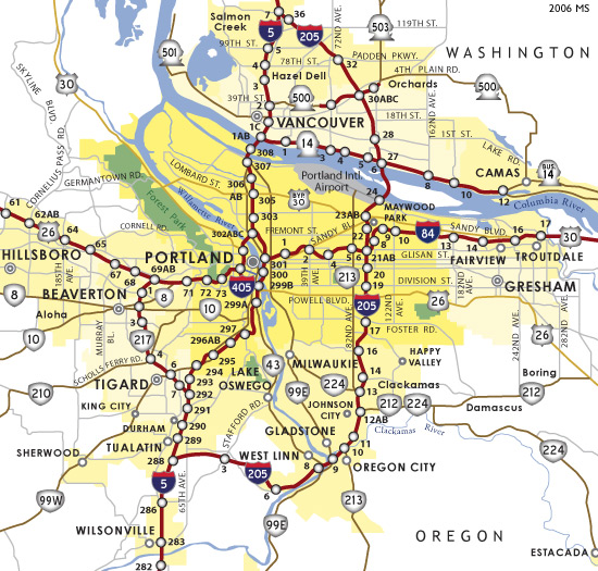
In order to show the location of the missing bike connection, I first need to show how the missing bike connection is connected to the Loop Road and Mooresville Road projects. The below map shows both projects. Starting from the left side of the map, the Mooresville Road project begins at Kannapolis Parkway and concludes at Dale Earnhardt Blvd, which is located where the red highlight is. The Loop Road project begins at West C Street, which is where the white dot is located above the orange highlight, and concludes at Main Street, which is where the pointer is located at 100 Loop Road. The missing bike connection, which can more easily be seen in the next map, is located between the Mooresville Road project and Loop Road project.

Where are the Mooresville Road and Loop Road projects located?

Where are the Mooresville Road and Loop Road projects located?

The below map shows where the proposed project on Loop Road ends at West C Street/South Walnut Street, which is where Loop Road changes names to Dale Earnhardt Blvd. The below map also shows where the proposed project on Mooresville Road ends at Dale Earnhardt Blvd, which is just before Mooresville Road changes names to Watson Crick Drive. The missing bike connection, which is highlighted in blue, is located on Dale Earnhardt Blvd between West C Street/South Walnut Street and Mooresville Road/Watson Crick Drive.

Loop Road to Mooresville Road Bike Connection

Loop Road to Mooresville Road Bike Connection

With the location in mind, below are the Mooresville Road and Loop Road project maps to provide proof that the missing bike connection is real. Since the Mooresville Road project maps are PDFs, I can’t show the maps so I have provided the links to the maps below. As NCDOT’s notice shows, there is a public hearing about the Mooresville Road widening project on Wednesday, July 9 from 4-6:30pm at the Cabarrus Health Alliance Building, which is located at 300 Mooresville Road in Kannapolis. I will be in Silver Spring, MD so cannot attend, but I encourage anyone interested in this project to attend.

Mooresville Road Widening Project from Kannapolis Parkway to Bethpage Road

Mooresville Road Widening Project from Bethpage Road to Dale Earnhardt Blvd

Below are the Loop Road project maps as of February 11, 2014. Since public hearings are still occurring for both projects, all the project maps are subject to change. Do you see the missing bike connection between the Mooresville Road project and the Loop Road project?

Loop Road Buffered Bike Lanes  from Biotechnology Lane to West C Street

Loop Road Buffered Bike Lanes from West C St/S Walnut St to Biotechnology Ln

Loop Road Buffered Bike Lanes from Biotechnology Lane to Main Street

Loop Road Buffered Bike Lanes from Biotechnology Ln to Main St

Kannapolis Owned vs. NCDOT Owned

The sections along Loop Road where the proposed road diet and buffered bike lanes could be installed may be transferred from NCDOT owned to City of Kannapolis owned. The sections along Mooresville Road where the proposed wider outside travel lanes for cyclists could be installed are currently NCDOT owned. Since both projects are not along sections of road that are city owned, I feel it is creating a difficult situation to make sure there is a safe and convenient bike connection between the two projects.

As of the resolution that was approved by Kannapolis City Council on Monday, June 23, Kannapolis is requesting NCDOT to abandon sections of Loop Road and Dale Earnhardt Blvd from State maintenance. This includes the entire project area for the road diet and buffered bike lanes on Loop Road and the missing bike connection on Dale Earnhardt Blvd. If NCDOT accepts the Kannapolis City Council’s request, these sections will be added to the City of Kannapolis’ Street System for maintenance. However, from what I have observed on the project maps, it doesn’t appear that this means the road diet and buffered bike lanes on Loop Road will be extended beyond the intersection of Loop Road and West C Street/South Walnut Street to the intersection of Dale Earnhardt Blvd (Loop Road changes names) and Mooresville Road/Watson Crick Drive. Since the Loop Road project will still end at West C Street/South Walnut Street, the missing bike connection will still exist.

After speaking with individuals involved in the Loop Road project, I discovered they have an alternative plan to create the bike connection between both projects. Instead of extending the road diet and buffered bike lanes to the intersection of Mooresville Road/Watson Crick Drive,  they want to end the road diet and buffered bike lanes at West C Street/South Walnut Street and route cyclists onto a multi-use path. They want to create this multi-use path through widening the sidewalk shown in the below photo. As one can see, there is a power line adjacent to the sidewalk. It probably is expensive to relocate the power line so the sidewalk can be widened for the creation of the multi-use path.

Power line may prevent widening of sidewalk for multi-use path

The Mooresville Road project, which is owned by the NCDOT, introduces another issue. Since the City of Kannapolis doesn’t own the sections of Mooresville Road where the proposed project is located, I feel it has less control over the proposed wider outside travel lanes for cyclists on Mooresville Road than it would have if these sections were owned by the city. One example of this can be seen in how the Mooresville Road project ends at Dale Earnhardt Blvd, which is just before Mooresville Road changes names to Watson Crick Drive. Since it would make the missing bike connection from the Loop Road project safer and more convenient, I would like NCDOT to extend the Mooresville Road project from Dale Earnhardt Blvd to Laureate Way.

Watson Crick Drive between Dale Earnhardt Blvd and Laureate Way

Watson Crick Drive between Dale Earnhardt Blvd and Laureate Way

Ray’s Redesign to Create Bike Connection

With the location and ownership details discussed for both projects, I will begin to discuss my proposed alternative route to create a safe and convenient bike connection between the Loop Road project and Mooresville Road project. This redesign assumes the City of Kannapolis and NCDOT cannot connect the two projects using the travel lanes on Dale Earnhardt Blvd.

Since I don’t yet (Portland State University has classes that teach photoshop) have photoshopping skills, imagine what the intersection of Loop Road/Dale Earnhardt Blvd and West C Street/South Walnut Street, which is shown below, would look like with a two-stage left turn box with bike detection. While I would prefer four two-stage left turn boxes be installed at this intersection because there are four possible locations to turn left, two boxes are needed to complete the alternative route that I am designing. One of these boxes needs to be installed for cyclists turning left from Loop Road onto South Walnut Street and the other box needs to be installed for cyclists turning left from South Walnut Street onto Dale Earnhardt Blvd. This redesign, along with the rest of my redesign, should encourage “interested but concerned” cyclists to bike between where the buffered bike lanes end on Loop Road and the wider outside travel lanes for cyclists start on Mooresville Road.

Inspiration for the words “Put a two-stage left turn box with bike detention on it!” in the caption for the below photo came from Complete Blocks. Complete Blocks is a cool project co-founded by Aleksandra Borisenko and Keihly Moore, who graduated from UNC Charlotte and now work for the Lawrence Group. Check out their website to see all the amazing complete block redesigns!

Put a two-stage left turn box on it!

Put a two-stage left turn box with bike detention on it!

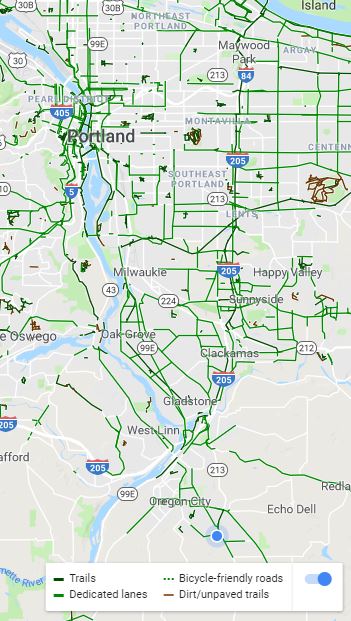
The below photo shows two-stage left turn boxes in Portland, OR. A similarly designed two-stage left turn box could be installed in Kannapolis.

Two-stage left turn box in Portland, OR

Two-stage left turn box in Portland, OR

Since most people in Kannapolis probably don’t know how to use a two-stage left turn box, Kannapolis would need to install the below sign to educate people, especially motorists and cyclists, on how to use the two-stage left turn box.

Sign on how to use two-stage left turn box in Portland, OR

Sign on how to use two-stage left turn box in Portland, OR

After turning left onto South Walnut Street, cyclists could bike on Rite Aid’s private road, which is located behind Rite Aid and connects to South Juniper Street. Several cyclists from the Central Carolina Cycling Club told me they already use this route so the City of Kannapolis could work with Rite Aid to make this a public-private sponsored bike route by installing multiple sharrows and Bikes May Use Full Lane signs. These sharrows and Bikes May Use Full Lane signs would direct cyclists where they need to be on the road and inform both cyclists and motorists where to expect cyclists to be biking. Since few automobiles use this route, which I know because I took several photos while standing in the middle of the road, and the automobiles that do use the route are traveling so slow, this route would provide a safe alternative to biking on Dale Earnhardt Blvd.

Put sharrows on it!

Put sharrows and Bikes May Use Full Lane signs on it!

Here is an example of what a sharrow is and what the Bikes May Use Full Lane sign looks like. Notice how the sharrow is properly installed outside the door zone. I see too may sharrows installed in the door zone so it is nice to see a properly installed sharrow.

Sharrow with Bikes May Use Full Lane Sign

Sharrow with Bikes May Use Full Lane Sign

After biking on Rite Aid’s private road, cyclists would turn right onto South Juniper Street then turn left onto Southern Select Community Credit Union’s parking lot. Sharrows and Bikes May Use Full Lane signs can continue to be used. Additional wayfinding may be needed if the sharrows don’t provide enough direction for cyclists to know where to turn.

Leaving Rite Aid and turning right onto Juniper Street

Leaving Rite Aid and turning right onto Juniper Street

Turning left into Southern Select Community Credit Union's parking lot

Turning left into Southern Select Community Credit Union’s parking lot

The alternative route concludes on the other side of Southern Select Community Credit Union’s parking lot, which connects to Watson Crick Drive. Watson Crick Drive changes names to Mooresville Road beyond the below intersection so the alternative route is complete. I am hopeful that the City of Kannapolis and NCDOT can work together to make sure the proposed wider outside travel lanes for cyclists on Mooresville Road will be extended to where Watson Crick Drive intersects Laureate Way.

2014-06-24 19.31.11

Turning right onto Watson Crick Drive, which changes names to Mooresville Road at the intersection

My proposed alternative route, along with suggested redesigns, should encourage “interested but concerned” cyclists to bike between where the buffered bike lanes end on Loop Road and the wider outside travel lanes for cyclists start on Mooresville Road. Whether or not my proposed alternative route is considered by the City of Kannapolis or NCDOT, I am hopeful that the City of Kannapolis and NCDOT can work together to make sure there is a safe and convenient bike connection between the Loop Road project and the Mooresville Road project. How feasible do you think my plan is? Are there areas I can improve my plan?

Since I will be moving from Kannapolis, NC to Silver Spring, MD on Sunday for a transportation planning internship with Toole Design Group, my next post will discuss my expectations for living car-free in the Washington, DC region. Since I have been dependent on an automobile for nearly every trip in Kannapolis and this is my first time moving outside the Charlotte region, I am confident that I will experience challenges. However, I also expect to experience many benefits from living car-free in the Washington, DC region.

Doris Day Parking in Kannapolis

What is Doris Day Parking? Start watching this clip at 0:59 to understand what Doris Day Parking is. Almost all, if not all, buildings in Kannapolis have Doris Day automobile parking. Before I start discussing the automobile and bicycle parking situations on the North Carolina Research Campus (NCRC), I need to mention that the NCRC is not fully built out yet. However, I feel this is not an excuse for the oversupply of automobile parking on the NCRC. Since there are many Transportation Demand Management (TDM) strategies that the City of Kannapolis and NCRC can pursue instead of adding more automobile parking, I believe there is already too much automobile parking for the fully built out NCRC. While there are TDM strategies being pursued, I believe the strategies aren’t strong enough. This is evident in how there is an oversupply of automobile parking, especially Doris Day automobile parking. Doris Day automobile parking continues to be built for every single building while only a few bike racks are being built. This is only one example of how weak the TDM strategies are in Kannapolis. My goal with writing this post is to discuss the extreme contrast between the oversupply of Doris Day automobile parking and undersupply of safe and convenient bicycle parking at UNC Chapel Hill’s Building on the NCRC.

I want to fully disclose that I graduated from UNC Charlotte, which competes with UNC Chapel Hill. The reason for writing this post does not involve this competition so please remember this as you read and comment on this post. As the below photo shows, the motorist was able to park only a few feet from the entrance to the building. Since Kannapolis provides so much Doris Day automobile parking, it encourages driving an automobile for every trip.

Doris Day Parking at the UNC Chapel Hill Building on the North Carolina Research Campus

Doris Day automobile parking at the UNC Chapel Hill Building on the North Carolina Research Campus

Here is a closer view of the surface parking area. This is Doris Day Parking because the stairs to the building entrance, which can be seen on the right side of the photo, are only a few feet from the parking spaces so motorists only have to walk a few feet to enter the building. In case you are wondering, it is free to park here. Before the next photo is shown, notice the six story parking deck in the background.

Dorris Day Parking at the UNC Chapel Hill Building on the North Carolina Research Campus

Dorris Day Parking at the UNC Chapel Hill Building on the North Carolina Research Campus

Even though there are six stories, only the bottom two floors were partially used when I took the below photo around noon on a work day. Considering the fact that the NCRC isn’t fully built out yet, do you see the potential for all six floors being full someday?

I would prefer the NCRC pursue a different route. This route could reduce the likelihood of all six floors being used and prevent having the need to build another parking deck or surface lot on the NCRC. In order to achieve this route, the NCRC and City of Kannapolis would have to implement TDM strategies that encourage use of sustainable modes of transportation instead of encouraging the use of the automobile for every trip. Given the fact that Kannapolis is very dependent on the automobile, do you see the potential for Kannapolis to implement strong enough TDM strategies that would encourage enough people to shift from driving their automobile to using a sustainable mode of transportation?

6 story parking deck on the North Carolina Research Campus

6 story parking deck on the North Carolina Research Campus

Not only do motorists have a six story parking deck that is barely used, they also have wayfinding signage to direct them to the parking deck. While this wayfinding signage helps to reduce vehicle miles traveled (VMT) because motorists can more quickly find where to park, there is no wayfinding signage to help bicyclists find where to park their bike.

Wayfinding signage to direct motorist to the parking deck

Wayfinding signage to direct motorists to the parking deck

Since I was determined to find where I was supposed to park my bicycle, which I struggled to park illegally to the sign below, I walked around the entire building. I struggled to park my bicycle because I had to lift it high enough for my U-lock to fit around the sign. While holding my bicycle high enough, I also had to maneuver the U-lock through the front wheel and frame. It took me at least a minute to lock my bicycle!

Location where I parked my bicycle

Location where I parked my bicycle

To my amazement, there was actually some bicycle parking located on the right side of the building and more located on the rear of the building. However, none of the bicycle parking was Dorris Day Parking like it was for automobile parking. I find it ironic that the UNC Chapel Hill Nutrition Research Institute, which is located inside this building, is researching how to “prevent or treat diseases like obesity, diabetes and cancer.” One simple and inexpensive way to work towards this goal is to install Dorris Day bicycle parking so people can feel encouraged to bike to the building instead of drive an automobile.

Bicycle parking at the UNC Chapel Hill Building on the North Carolina Research Campus

Bicycle parking at the UNC Chapel Hill Building on the North Carolina Research Campus

To make matters worse, the bicycle parking that has been provided is the same poorly designed and installed bicycle parking that was installed at Rowan-Cabarrus Community College’s NCRC Building. Even though UNC Chapel Hill and/or the NCRC probably received Leadership in Energy and Environmental Design (LEED) points for installing wheel bender bike racks, I cannot safely use the poorly designed wheel bender bike racks. As the below photo shows, the wheel bender bike rack is poorly designed because the person who owns the bike cannot lock the bike rack with the front wheel and frame using a U-lock. Instead, the person is forced to use a wire lock, which can easily be cut.

Unfortunately, the issue goes beyond the infrastructure that is installed. Education is also needed to educate cyclists on how to properly lock their bike. This issue can be seen in how the wire lock in the below photo was only locked to the frame and not to the frame and front wheel. Since the front wheel is quick release, the front wheel can easily be stolen so a U-lock needs to be used to lock the front wheel and frame to the bike rack. The wheel bender bike racks cannot reach the frame so a safer type of bike rack is needed.

Wire lock is only locked to the frame so front wheel, which is quick release, can be stolen

Wire lock is only locked to the frame so front wheel, which is quick release, can be stolen

In addition, the wheel bender bike racks are poorly installed because the side entrance door to the building is locked so visitors have to walk around to the front of the building to enter. The poorly designed and installed bicycle parking does not promote bicycle use to the building. Since there isn’t correctly designed and installed bicycle parking, I am forced to risk getting a ticket for parking my bicycle illegally. I value the safety of my bike more than using an inferior product. Will UNC Chapel Hill or the NCRC install safe bike racks to replace the wheel bender bike racks?

Inconveniently located and poorly designed bicycle parking

Inconveniently located and poorly designed bicycle parking

The below photo shows one potential location for inverted U bike racks to be installed. I chose this location because it provides cyclists with convenient access to the front door, which is open for visitors. Through providing people with convenient bike parking, it encourages them to bike to the building instead of drive an automobile.

Location for Inverted U bike racks

Location for Inverted U Bike Racks (Photoshop: Keihly Moore/Lawrence Group)

One way to encourage people to bike to the building even more is to provide covered bike racks so bikes aren’t exposed to the elements.

Location for Covered Inverted U Bike Racks (Photoshop: Keihly Moore/Lawrence Group)

Location for Covered Inverted U Bike Racks (Photoshop: Keihly Moore/Lawrence Group)

I have discussed the extreme contrast between the oversupply of Doris Day automobile parking and undersupply of safe and convenient bicycle parking. Since I move to Silver Spring, MD on June 29, I only have time to write two more blog posts before I leave. My next post should be about my proposed redesign of a difficult bicycle connection between where the proposed buffered bike lanes on Loop Road end and the proposed bike lanes on Mooresville Road end. Following this post, I plan to discuss my expectations of living car-free in Silver Spring, MD and the Washington, DC region. After I arrive in Silver Spring, MD, I plan to discuss whether or not my expectations came true and what challenges and benefits I am experiencing from living car-free in Silver Spring, MD and the Washington, DC region.