Key West at Eye Level: Part 3

“Key West at Eye Level” is a reference to “The City at Eye Level”. I am trying to focus on positive things as I have many negative thoughts regarding the approaching immigration nightmare. One positive thought is how I got a new bike rack installed near my home in Key West. I saw a neighbor’s bike locked to the speed limit sign pole, so I used the Key West Connect app to work with my coworkers to install a new bike rack near the existing bike rack.

Photo credit: Ray Atkinson

Future Blog Post

The next few months are going to be life-changing for thousands of documented, legal immigrants and their families in Key West. Many of these immigrants are about to lose their jobs and legal status. I bike, walk, and ride transit with immigrants daily. They are some of my closest friends in Key West. While I struggle with learning new languages, they are helping me to learn and practice my French, Haitian Creole, Portuguese, and Spanish skills. I am returning the favor by providing them with opportunities to learn and practice their English skills. Since I do not want to risk losing my job by spotlighting the immigration nightmare, does anyone know how to spotlight this situation without receiving backlash from all levels of the government?

Key West at Eye Level: Part 1

“Key West at Eye Level: Part 1” is a reference to “The City at Eye Level”. While I honestly miss having enough time to publish long blog posts, I am thankful to be enjoying Key West so much that I do not have enough time to publish long blog posts anymore. I am still trying to publish at least one blog post each month. Since I have not published a post in June yet, I wanted to quickly publish a post before I participate in the Key West Pride Parade. I identify as a demisexual, so I personally celebrate Pride. June is Pride Month, so happy Pride Month!

ICE Raids Are Happening In Key West!

I believe most Americans think that the ICE raids are only happening in Los Angeles. While I am also concerned about what is happening in Los Angeles, ICE raids are also happening in Key West. The Key West City Commission scheduled a special meeting tomorrow, June 30th, to discuss the ICE raids. I submitted public comment. I took the below photos as I walked around Key West. I think the photos show proof of how the Key West community has a strong heart for being One Human Family. I love living and working in a community that supports being One Human Family!

Source: photo by Ray Atkinson
Source: screenshot by Ray Atkinson
Source: photo by Ray Atkinson
Source: screenshot by Ray Atkinson

Future Blog Post

I hope the ICE situation improves soon. Since President Trump’s One, Big, Beautiful Bill has plenty of funding to hire more ICE agents and Governor DeSantis has ordered the construction of Alligator Alcatraz, I am concerned that the ICE situation will get worse before it calms down. I want to return to blogging about more enjoyable topics like how much I enjoy living and working in Key West. How is the ICE situation where you live?

Remembering Legendary Kannapolis Historian Norris Dearmon and Happy 10th Anniversary to My Blog!

I was originally planning to write a quick memorial post about legendary Kannapolis, NC historian Norris Dearmon, who died yesterday at 100 years old. He had a long and impactful life. Since I volunteered with his son, Eric Dearmon, I am keeping him in my thoughts as I remember his father. As the below photo shows, I was fortunate enough to learn from Norris while I was creating my senior exit project at Northwest Cabarrus High School in 2009. My project was titled the Impact of the North Carolina Research Campus on Kannapolis. Norris and I shared our love and passion for history and maps. Mrs. Andersen, I know you read my blog. Thank you for being my senior exit project advisor!

Ray looking at a historic photo of Kannapolis, NC from the mid-1900s with legendary historian Norris Dearmon at the Kannapolis Library in 2009 for Ray’s high school senior exit project

While I have not been blogging long enough to have included my high school experiences when they happened, WordPress surprised me with the below Happy 10-Year Anniversary when I logged in tonight. I made it to 10 years! On the 10-year anniversary of my blog, I think Norris would have been proud of how I have continued to promote the value of learning history.

As I write this post in Petaluma, I find it interesting to reflect on the fact that I had not even heard of Petaluma when I started my blog in 2014. While I pride myself on being a geographer who knows where places are located, I also did not even know the location of Petaluma within California when I lived in Oregon. My blog has been through an international geographic journey. I am excited to visit and blog about more places around the world!

I try not to be jealous, but I think it would have been fun to celebrate this achievement in a similar fashion to how BikePortland’s supporters celebrated the 10-year anniversary of BikePortland.org in 2015. Yes, I realize BikePortland has more readers and active engagement than my blog. We have different blogging styles. I prefer using my blog to write my autobiography for me and my future family. Since I am very curious about how my future wife and kids will react to my blog, I hope that I have the opportunity to get married and have kids.

Future Blog Post

Here is to the next 10 years of my blog! What is your favorite post from my first 10 years of blogging?

Virginia’s Lee Highway Alliance experiments with State of Place’s walkability analysis tool

Today is the National Day on Writing, which asks people to share why they write using #WhyIWrite. I started this blog in 2014 and wrote the following post because I’m passionate about opening people’s eyes to transportation issues that I also used to be blind to. Since Greater Greater Washington‘s staff helped me write this post so it could be posted on their blog, the structure is different from what I usually write on my blog.

The Lee Highway Alliance (LHA) in Arlington, Virginia is working to make the Lee Highway Corridor more economically vibrant, walkable, and attractive. State of Place is helping them achieve their walkability goals. Walkability is simply a measure of how friendly a given place is to walking. People who live in highly walkable places see a slew of health, environmental, and financial benefits.

The Lee Highway Corridor is located in north Arlington just north of the Rosslyn-Ballston Corridor. Unlike the Rosslyn-Ballston Corridor, which helped Arlington win the Gold 2017 National Planning Achievement Award for Implementation, the Lee Highway Corridor remains a primarily automobile-dependent, suburban-style place.

Rosslyn-Ballston Corridor Past-Present

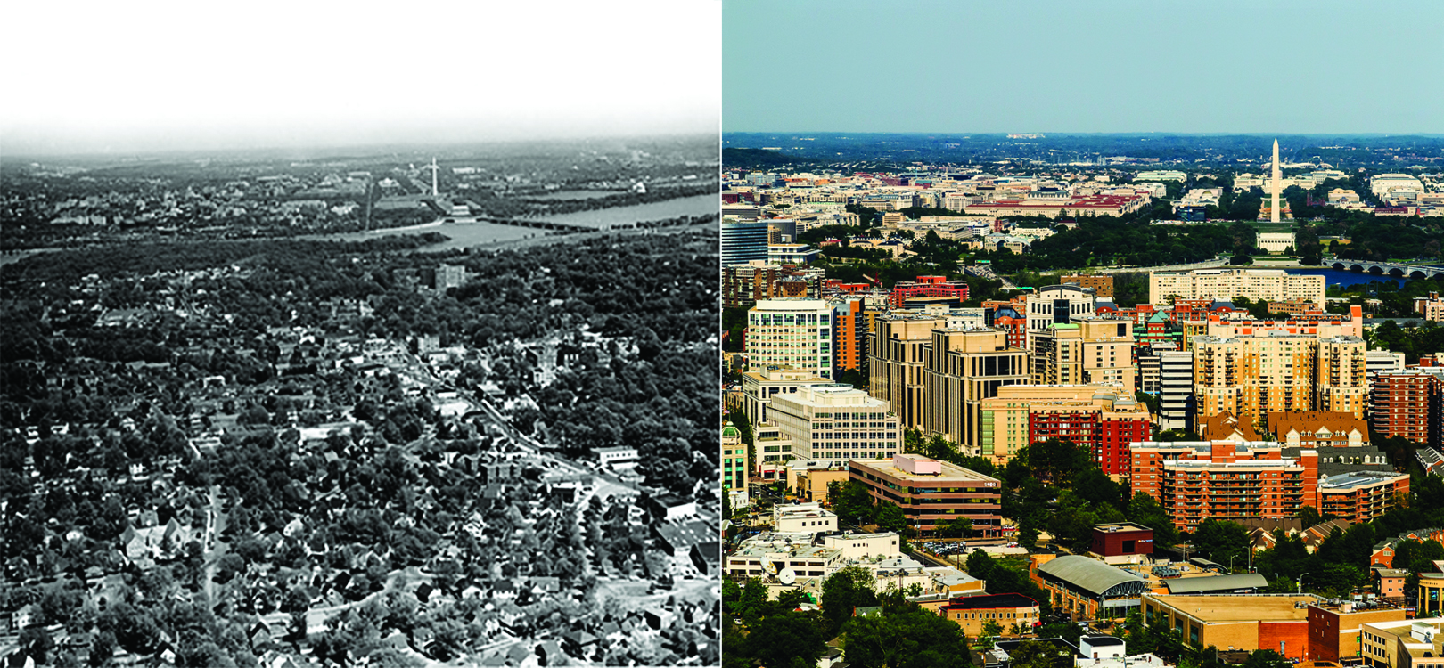
Rosslyn-Ballston Corridor, past and present. Images by Arlington.

As is typical of most of the commercial corridors built throughout the country during the mid-to-late 20th century, the general development pattern of the Lee Highway Corridor is low-rise commercial development with prominent surface parking lots and limited pedestrian, bicycle, and transit infrastructure.

It is a major automobile commuter corridor. In order to create the place that the LHA envisions, the Lee Highway Corridor needs to become a place that prioritizes people and community over automobiles.

Since the LHA wants to provide people with healthy transportation choices and attract vibrant economic development, it hopes to improve the Lee Highway Corridor through a new vision that includes distinct, walkable, mixed-use neighborhood centers.

Lee Highway Corridor Future Intensity

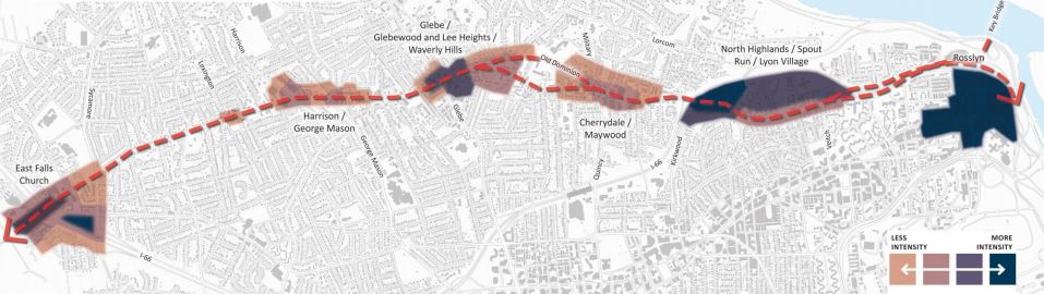
Proposed neighborhood centers showing a spectrum of density. Image by Arlington.

One of the proposed neighborhood centers, Lee Heights shopping center, is shown below:

Lee Heights Shopping Center Illustration

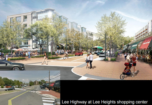
Illustrative concept for Lee Heights shopping center, existing and proposed. Image by Arlington.

There are many tools that cities or other planners use to determine how pedestrian-friendly an area is and how they can improve “walkability.”

So how do planners determine how walkable an area is?

You can see a walkability analysis in action in Virginia

Recently, LHA was one of six organizations across the US to win a five-block walkability analysis from State of Place, a software company that uses predictive analytics to quantify what people love about a given place.

State of Place uses ten urban design categories, such as density, connectivity, and traffic safety, to assess how walkable a block, a group of blocks, or an entire neighborhood is. During the past several months, they assessed the walkability of Lee Highway. Results will be presented to the public on Saturday, October 21 from 10am-12pm at the Lee Highway Alliance office, which is located at 4620 Lee Highway, Suite 208.

There are pros and cons to all walkability assessment tools

State of Place’s approach isn’t the only walkability assessment tool available. Another tool is called Walk Score, which provides a number on the 100-point scale that measures the walkability of any address.

Most cities use Walk Score, but State of Place walkability researcher Dr. Mariela Alfonzo says this tool tends to overestimate the walkability of high-access, low-income communities, among other problems.

Joe Cortright at City Observatory rebuked Alfonzo’s criticisms, saying State of Place’s metrics are highly complex, extremely labor intensive to gather, and consequently very expensive. Plus, they have not been implemented enough to let an objective third party assess their accuracy and utility.

While there is no perfect way to assess how walkable an area or city is, both tools are a great start to understanding how to improve the accessibility and livability of a given area.

Here’s how walkability scores are created

I’ve had the opportunity to personally use the State of Place tool to conduct a similar analysis in Tigard, Oregon last year. With help from three of my Master of Urban and Regional Planning classmates from Portland State University, we created neighborhood walkability assessments for the Tigard Triangle and Downtown Tigard.

Delta Planning Team with Client 2-10-16

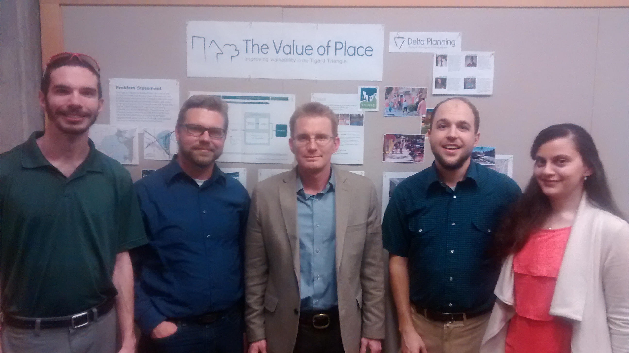
Team of Master of Urban and Regional Planning students from Portland State University with client, Lloyd Purdy of Tigard, OR (left to right: Ray Atkinson, Curtis Fisher, Lloyd Purdy, Linn Davis, Wala Abuhejleh)

My team used the inventory tool to capture data on more than 280 built environment features, in ten urban design categories, that contribute to the walkability on every street segment in this area.

We underwent a rigorous training process where we practiced using the inventory tool in four different sample settings. Individual results from the four sample settings weren’t exact matches, so we understand our data collection in the Tigard Triangle and Downtown Triangle isn’t completely accurate. For example, one person could have felt safe walking on a street segment while another person didn’t feel safe walking on the same street segment.

We walked 74 street segments in the Tigard Triangle and 15 street segments in Downtown Tigard. The data was submitted to State of Place, who used their proprietary algorithm to generate an Index score for each segment on a 100-point scale. The results are shown below:

Downtown & Triangle SoP Index

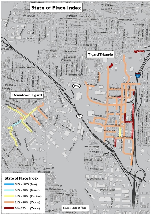
State of Place Index for Tigard Triangle and Downtown Tigard

The index for the Tigard Triangle is 33 out of 100, a low walkability score meaning most trips require an automobile. For comparison, Downtown Tigard scored 66.

The profile breaks the index down into ten urban design categories that contribute to the walkability of the place, so cities can know where to prioritize walkability improvements. As the profile shows, the weakest category for the Tigard Triangle is lack of parks and public spaces.

State of Place Index & Profile Tigard Triangle

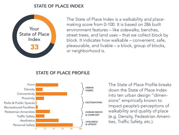
State of Place Index and Profile for Tigard Triangle

However, increasing parks and public spaces don’t do as much for walkability as adding density, pedestrian amenities, and traffic safety.

Since most cities have scarce resources, State of Place also provided the “Weighted by Impact and Feasibility (Walkability)” chart, shown below. Constructing a building is expensive and often depends on the private sector, so density isn’t the most feasible way to improve walkability.

Since the public sector has more control over adding pedestrian amenities and improving traffic safety, and the non-weighted profile shows these are weak in the Tigard Triangle, they are the most feasible ways to improve walkability in this place.

State of Place Prioritization Tigard Triangle

State of Place Prioritization Tigard Triangle2

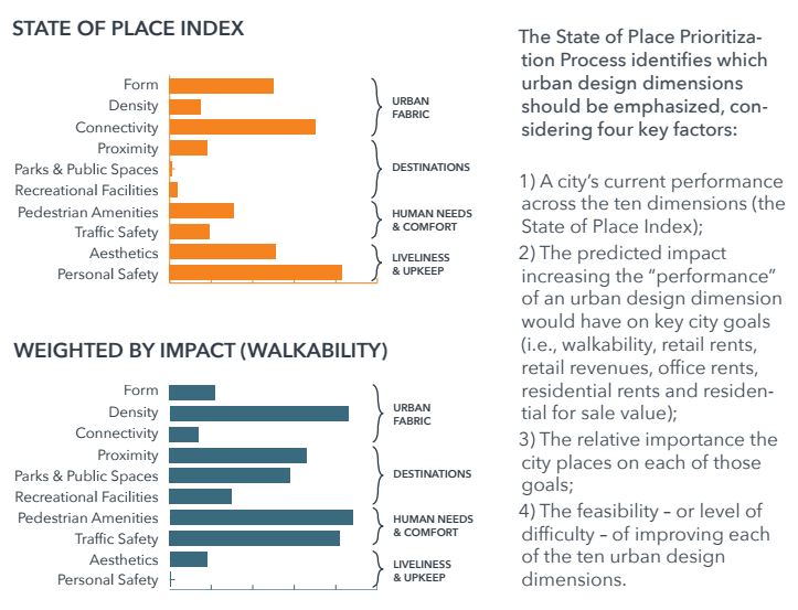
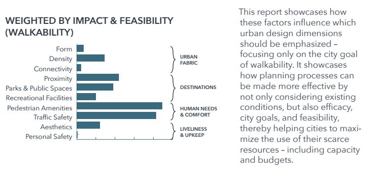
State of Place charts for Tigard Triangle

The city used this data and my team’s recommendations to help create the Tigard Triangle Lean Code, which was adopted in August 2017. The lean code promotes building and site designs that improve walkability.

Tigard Triangle Lean Code

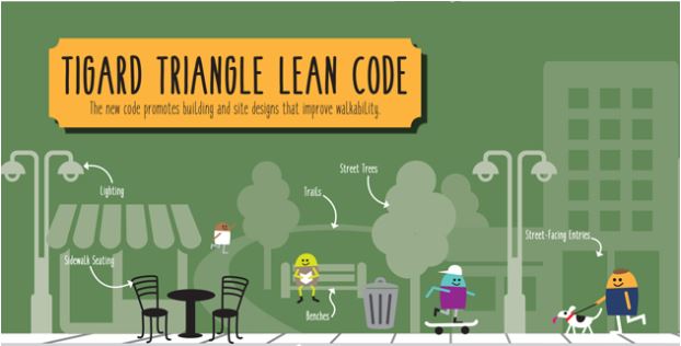
Tigard Triangle Lean Code. Image by Tigard.

If this analysis interests you, results from the Arlington walkability analysis will be presented to the public by State of Place on Saturday, October 21 from 10am-12pm at the Lee Highway Alliance office, which is located at 4620 Lee Highway, Suite 208. I plan to write a post with public reaction to the results.

Neighborhood Greenways Are Cool, But Oasis Greenways Are Awesome!

I submitted my contributor form to Greater Greater Washington (GGWash) today and GGWash’s staff gave me the green light, so my first blog post should be published on GGWash sometime next week. Since GGWash’s staff asked me to write differently than I write on my personal blog, I wanted to share the version I wrote before GGWash’s staff asked me to shorten my blog post and make it less technical. As I wrote in this post, I knew I would have less control over my writing when I started posting on other blogs. I’ll share my GGWash post after it is published, but as a teaser I’m sharing my longer and more technical version below.

Update: here is my first GGWash post!

A bike boulevard (DC region refers to neighborhood greenway as bike boulevard) is an outdated idea currently being used by many US cities to improve safety for all street users. An oasis greenway is a new approach that represents the future of safe street design. An oasis greenway is a long series of interconnected low-speed, low-volume, shared-space, vegetated linear parks created from an assembly of residential streets. As the below video shows, an oasis greenway is based on the Dutch woonerf.

According to Tom Bertulis’ 167-page thesis, Oasis Greenways: A New Model of Urban Park and Bikeway within Constrained Street Rights-of-Way, the nine elements that any given facility must include to be called an oasis greenway are the following:

  1. Extremely low traffic volumes, including traffic diversion as needed. While many cities in the US are focused on traffic diversion on a street by street basis, several cities in the Netherlands are focused on traffic diversion on a neighborhood or citywide basis. Houten, Netherlands, which is a suburb of Utrecht, has implemented a citywide traffic diversion plan.

    Houten Street Network

    Houten’s traffic diversion map. Source: ITDP

    As the below map shows, motorists are routed from their neighborhood road (green) onto a connector road (brown) that directs them to the outer ring road (yellow). Motorists must drive all the way around Houten until they reach another connector road that connects them to their destination. Since cyclists and pedestrians can travel through the traffic diverters, they can travel quicker than motorists through Houten.

    Houten Street Network zoomed in

    Neighborhood level of Houten’s traffic diversion map

    Watch this video to learn more about Houten.

    Since Houten was originally designed with traffic diversion, it is a unique city because it didn’t need to be retrofitted. Most, if not all, US cities will have to retrofitted with traffic diversion so here is a neighborhood retrofit example from Utrecht, Netherlands. US cities should be able to relate to this retrofit example much easier than the approach that Houten took with its citywide traffic diversion plan.

    While no US city has implemented a citywide nor neighborhood network of traffic diverters, Portland, OR has several traffic diverters. Here is a diagonal traffic diverter in northeast Portland.

    2015-07-26 16.21.38

    Diagonal traffic diverter at NE Tillamook St and 16th Ave. Photo: Ray Atkinson

    Diagonal traffic diverter at Tillamook and 16th

    Diagonal traffic diverter at NE Tillamook St and 16th Ave

  2. Extremely low traffic speeds, including traffic calming as needed. Below is a bayonet traffic calmer in Delftweg, Netherlands. While the street is two-way, the bayonet forces motorists to take turns going through the bayonet. Cyclists have a two-way trail so they can avoid the bayonet.

    DSCN0394

    Delftweg’s bayonet traffic calmer. Photo: Ray Atkinson

  3. Shared space, without sidewalks, with motorists sharing the space with pedestrians and cyclists, like a woonerf.

    Bell Street Seattle Before & After Shared Space

    Shared space on Bell Street in Seattle, WA

  4. Oasis greenways must be continuous for at least several blocks and have connectivity through busy intersections.

    Portland Neighborhood Greenway Crossing

    Portland neighborhood greenway crossing. Photo: Steven Vance

  5. Terminal vista. They must make use of the “terminal vista effect,” where the line of sight straight down the street is partially obscured, usually by trees or an on-street parking chicane. The below woonerf in Delft, Netherlands shows the terminal vista effect.

    Delft woonerf

    Woonerf in Delft, NL. Photo: Ray Atkinson

  6. Parklike, which refers to using grasscrete as the default in areas that aren’t travel-ways for cyclists and pedestrians. The below photo from Haarlem, Netherlands shows a grasscrete street.

    Grasscrete in Netherlands

    Grasscrete street in Haarlem, NL. Photo: Dan Burden

  7. Park and parking strip. They must have a wide area where on-street parking, parklets, trees, vegetation, and play areas are located.

    Oasis greenway park and parking area

    Rendering of park and parking strip. Rendering: Tom Bertulis’ thesis

  8. Minimal parking footprint. They must minimize the parking footprint based on a parking needs analysis. Use the below illustration to compare parking footprint of a traditional street with parking footprint of an oasis greenway.

    Oasis Greenway vs. Traditional Street

    Source: Tom Bertulis’ thesis

  9. Small and large play areas. They must have both small and large play areas, with the small play areas referring to the Park & Parking Strip and the large play areas referring to Oasis Greenway sections with “ultra-low volumes” where the play area temporarily becomes the entire cross-section of the street, not too different from when hockey is played in the street.

    Street Hockey

    Street hockey. Photo: Jonathan Tavares

While no street in the US has been designed with all nine elements of an oasis greenway, a few cities have experimented with several elements of an oasis greenway so please don’t think that an oasis greenway can only be designed by the Dutch or Europeans. Would you like to see an oasis greenway constructed in your neighborhood? If yes, where? If no, why not?

Future of Ray’s Blog

Since I have almost 50 drafts waiting to be published on my blog, I’m not concerned about not having anything to post on my blog so I feel my blog’s future is secure. Instead, I keep thinking about what I want the goals of my blog to be and whether I want to start posting on other blogs like GGWash.org. These thoughts intensified after I attended Greater Greater Washington (GGWash)’s blogging workshop last Thursday night. I didn’t realize GGWash seeks volunteer bloggers to post on their blog. After receiving feedback on my blog ideas and hearing their excitement for my blog ideas, I’m planning to give GGWash a trial run to see how the experience goes. I learned through the blogging workshop that the writing style I use on this blog is very different from the writing style they expect for posts on GGWash so I’m curious to see which writing style I prefer. The post I plan to write on GGWash is a post I have been planning to write on my blog so I plan to write one version on GGWash and one version on my blog.

ggwash-logo

Source: GGWash.org

In order to reflect on my experience blogging on GGWash and how I want to continue blogging on my blog, I need to provide my initial thoughts. Most of my blog posts have several photos and/or videos so I hope this post isn’t too boring to read. Even though I’m mostly writing this post for myself so I can easily reflect on my blogging experiences, I wanted to share my thoughts publicly in case anyone wants to share their thoughts or learn from my experiences. I know several of my friends are thinking about whether to start blogging so this post may be helpful for them.

With the background info covered, I have been thinking about my blog goals and goals for posting on GGWash. When I first started my blog during Spring 2014, one of my goals was to avoid posting on other blogs because I didn’t want people to prevent me from showing my full passion. While I’m still concerned about GGWash’s staff preventing me from showing my full passion in my posts, I feel my job has handcuffed me from showing my full passion on this blog. Due to this, I have become more comfortable with allowing people to filter my passion and not being allowed to show my full passion through blogging. Even though I’m depressed by this reality, I enjoy my job so I want to keep my job. I feel this means I have to sacrifice the true reasons why I started my blog or stop blogging all together.

Since I don’t feel I can continue blogging for the true reasons why I started blogging, what are my new blog goals? I still want to reflect on my experience growing up in a home that has a Walk Score of zero to now living in a home where I can easily live car-free. I want to keep sharing my blog with my family, friends, and future girlfriend so everyone can follow my life. I also want keep using my blog to help educate people on issues that are important to me and I feel educated enough to write about.

Due to my job, I feel handcuffed to use my blog as much for advocacy so I’m still thinking about my advocacy goal for my blog. I still want to use my blog to persuade people about my viewpoint, but I hate feeling the need to be careful about what I write when I try to persuade people. For example, I want to persuade people that Arlington County (my client)’s bike boulevard plans need to be more progressive. In order to do this, I feel I need to critique my client’s plans. I don’t want to publicly embarrass my client so how can I write an advocacy post about Arlington County’s bike boulevard plans without jeopardizing my job?

I discussed this barrier with GGWash’s staff and they understood why I feel handcuffed. They suggested I write about areas of the DC region where I don’t work. While this approach could work, I told them that Capital Bikeshare likely will keep expanding into all the suburban counties surrounding DC. I don’t want an advocacy blog post about a county I’m not currently working in to come back and haunt me 10 years from now when I start working in the county. GGWash’s staff understood my concerns so I look forward to working with them to see how I can write advocacy blog posts that won’t haunt me 10 years from now.

A major reason why I’m passionate to post on GGWash is because it has “200,000 unique visitors and more than 500,000 page views every month.” The blog visitors include “elected officials, reporters, urban planners, and civically engaged residents.” While I don’t mind not having too many visitors on my blog because it is mostly for me to reflect on my life, I’m excited about the potential to engage with 200,000 visitors on GGWash about topics I’m passionate and educated about. In the past, I have engaged with blog users in the comment section. After hearing passion from GGWash’s staff about my blog ideas and learning that no one has posted my blog ideas on GGWash yet, I feel I’m ready to take my blogging experience to the next level and post a high-profile blog post on GGWash.

How Ray’s Blog Got Started

Several people, including my new Association of Pedestrian and Bicycle Professionals (APBP) mentee, have asked me recently why I started blogging. Even though I wrote this post about what my blog title “0 to 100” means, I’m shocked I never wrote the story about who inspired me to start blogging. Stephan Hoche and I were catching up during Spring 2014 at Zada Jane’s Corner Cafe in Charlotte’s Plaza Midwood Neighborhood. I remember Zada Jane’s Corner Cafe because we were playing shuffleboard. Stephan and I were close friends at UNC Charlotte so Stephan constantly heard my passion. I was preparing to move to Maryland for an internship at Toole Design Group then Oregon for grad school at Portland State University so Stephan encouraged me to blog about my passion and my upcoming adventure. He even helped me come up with my blog title “0 to 100”.

stephan-and-ray

Ray (Left) and Stephan on November 26, 2016

As people ask me to reflect on my blog, I have reflected on what I was thinking when I started blogging during Spring 2014 and how my thoughts have changed over the years. When I started blogging during Spring 2014 I felt near complete freedom to blog about any topic. I didn’t have a job so I didn’t feel a need to be careful about what I wrote on my blog. Fast forward to today and I now have a full-time job that involves consulting for several governments in the Washington, DC region. These governments work on projects that I want to blog about so I have to be more careful what I write than I expected when I first started blogging.

Even though it wasn’t a major focus when I started blogging, my APBP mentee asked me whether I started this blog to help me get noticed by employers so I could get a job. While many employers asked me about my blog during job interviews, I believe my blog may have actually scared many employers away from me. Many employers told me during my post-grad school job interviews that based on what they read in my blog posts they were concerned I was too passionate and wouldn’t give up if they told me “no” to a progressive idea.

I know Stephan reads my blog posts. Since I can’t tell you thank you in person for inspiring me to start blogging, I hope this blog post will serve as a thank you.