From Wikimedia Commons, the free media repository
<nowiki>Islas Spratly; Kepulauan Spratly; Kaislahan kan Spratly; Спратли; Spratly Adaları; جزائر سپراٹلی; Súostrovie Spratly; Острови Спратлі; 南沙群島; 南沙群岛; ໝູ່ເກາະສແປຣຕລີ; 스프래틀리 군도; Spratly oyggjar; Spratly-insularo; Spratlyho ostrovy; Nanzsah ginzdauj; îles Spratleys; Otočje Spratly; 南沙群岛; स्पॅटली आईसलँड्स; quần đảo Trường Sa; Spratlija salas; Острва Спретли; 南沙群岛; Спратлийн арлууд; Lâm-soa Kûn-tó; Spratlyøyene; Spartli arxipelaqı; ಸ್ಪ್ರಾಟ್ಲಿ ದ್ವೀಪಗಳು; Spratly Islands; جزر سبراتلي; Inizi Spratly; 南沙群島; Spratly-szigetek; સ્પ્રાટલી આઇલેન્ડ્સ; Spratly uharteak; Islles Spratly; Острова Спратли; Spratly-Inseln; Oileáin Spratly; جزایر اسپراتلی; 南沙群岛; Spratlyøerne; სპრატლის კუნძულები; 南沙諸島; איי ספראטלי; Ìxołe Spratly; 南沙群岛; ប្រជុំកោះស្ព្រាតលី; 南沙群岛; Spratlysaaret; Spratly-Eilunen; 南沙群島; Spratlyöarna; இசுப்ராட்லி தீவுகள்; Isole Spratly; Spratly Islands; หมู่เกาะสแปรตลี; Kapupud-ang Kagawasan; Астравы Спратлі; Острови Спретли; Otočje Spratly; نەنشا تاقىم ئاراللىرى; ස්ප්රටලි දුපත්; Àwọn Erékùṣù Spratly; Spratlyøyane; Ilhas Spratly; illes Spratly; Insulele Spratly; স্প্র্যাটলি দ্বীপপুঞ্জ; Spratlio salos; Spratlyjevo otočje; Kapuluan ng Kalayaan; Spratly-Insuli; స్ప్రాట్లీ దీవులు; Kepulauan Spratly; Wyspy Spratly; സ്പ്രാറ്റ്ലി ദ്വീപുകൾ; Spratly-eilanden; Архіпелаг Спратлі; 南沙群島; 南沙群岛; 南沙群島; Illas Spratly; 南沙群岛; Νησιά Σπράτλι; स्प्रैटली द्वीप समूह; arcipelago nel Mar Cinese Meridionale, giacente sul 10º parallelo, tra le coste delle Filippine, del Vietnam e del Brunei; szigetcsoport a Dél-kínai-tengeren; архіпэляг у Паўднёва-Кітайскім моры; архипелаг в юго-западной части Южно-Китайского моря; inselgruppe nordwestlich Borneo; nhóm các đảo, cồn cát, bãi cạn có tranh chấp ở Biển Đông; архіпелаг у Паўднёва-Кітайскім моры; arhipelāgs Dienvidķīnas jūrā; 南中國海群島; skupina grebenov, otočkov, atolov, zalivov in otokov severozahodno od Bornea (v Tihem oceanu); 南シナ海南部に位置する諸島; گروهی از جزیرهها، خردهجزیرهها و آبسنگها در دریای جنوبی چین; grupp atoller i Sydkinesiska havet; kepulauan di Tiongkok; pinag-aagawang kapuluan sa Dagat Kanlurang Pilipinas; øygruppe i Sørkinahavet; 位於南海的群島; 位於南海的群島; archipel en mer de Chine; 남중국해의 제도; saariryhmä Etelä-Kiinan merellä; group of reefs, islets, atolls, cays and islands; grupo de insuloj kaj atoloj en Sudĉina Maro; souostroví v Jihočínském moři; arquipélago disputado no Mar do Sul da China; Islas Libertad; Nansha Qundao; Spratly; Islas Nansha Qundao; Iles Spratley; Îles Paracel et Spratly; Spratleys; Îles Spratley; Îles Paracel et Spratley; Спратлі (астравы); Чыонгша; Спратли; Наньшацюньдао; Коралловые острова; स्पॅटली आईसलँडस; Spratlys; Nansha-Inseln; Kalayaan-Inseln; Nansha Qundao; Spratly; Vạn Lý Trường Sa; Vạn Lí Trường Sa; Trường Sa; quần đảo Nam Sa; Nam Sa; nhóm đảo Kalayaan; quần đảo Spratly; Спратлі; 团沙群岛; 斯普拉特利群岛; 長沙群島; 卡拉扬群岛; 南沙群島; Spratly Islands; Spratly; カラヤアン諸島; ナンシャー諸島; 南沙; スプラトリー諸島; 新南群島; 南沙群島; Nansha Qundao; Amboyna Cay; Spratly Islands; Spratly Islands; Spratlys; Spratly; Spratly Islands; Spratly; ස්පාර්ටලී දූපත්; Pulong Spratley; Pulo ng Spratley; Spratley island; Pulo ng Spratly; Kapuluang Kalayaan; Kapuluang Spratly; Kapuluan ng Spratly; Spratly Island; Pulong Spratly; Mga Pulo ng Kalayaan; Isla ng Spratly; Islang Spratly; Islang Spratley; Isla ng Spratley; Spratly Islands; Distretto di Truong Sa; Isole Spratley; Spratley; Spratly; स्प्रैटली द्वीप; स्प्रैटली द्वीप-समूह; स्प्राट्ली द्वीप; స్పార్ట్లీ దీవులు; 스플래틀리 군도; 난사군도; 남사 군도; 스프래틀리 제도; 쯔엉사 군도; 장사군도; 남사군도; 난사 군도; South Sand Islands; Nansha Islands; Kalaayan Island Group; Kalaayan Islands; جزر ناتشا; Nanša; Spratlyovy ostrovy; ஸ்ப்ரைட்ல்லி இஸ்லாண்ட்ஸ்</nowiki>
map (2015)
A geographic map of Spratly Islands
In the
Mao Kun map , Spratly Islands are suggested to be the islands at the bottom right (
). Others however believe they referred to the
Paracel Islands or
Macclesfield Bank
The
Velarde map shows Galit, Pancot, and Lumbay, which the Philippines identifies as the
Scarborough Shoal and islands off of
Palawan .
The Spratlys labeled as
"Los Bajos de Paragua" off the coast of
Palawan (
Paragua ) on the
Velarde map
An 1801 Cary Map of the East Indies and Southeast Asia showing Panacot, the Scarborough Shoal, Amphitrite, the Paracels, and what is now known as the Spratlys
An 1838 Unified Dai Nam map marking
Trường Sa and
Hoàng Sa , which are considered as Spratly and
Paracel Islands by some Vietnamese scholars
A British chart of the sea in northern Borneo, first issued in 1881 and corrected in 1935
Young Vietnamese residents
A military cemetery for Vietnamese soldiers on Central London Reef
The Pearson Reef dock under Vietnam's administration


 map (2015)
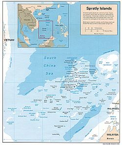 A geographic map of Spratly Islands
 In the Mao Kun map, Spratly Islands are suggested to be the islands at the bottom right (中文:(missing text)). Others however believe they referred to the Paracel Islands or Macclesfield Bank
 The Velarde map shows Galit, Pancot, and Lumbay, which the Philippines identifies as the Scarborough Shoal and islands off of Palawan.
 The Spratlys labeled as "Los Bajos de Paragua" off the coast of Palawan (Paragua) on the Velarde map
 An 1801 Cary Map of the East Indies and Southeast Asia showing Panacot, the Scarborough Shoal, Amphitrite, the Paracels, and what is now known as the Spratlys
 An 1838 Unified Dai Nam map marking Trường Sa and Hoàng Sa, which are considered as Spratly and Paracel Islands by some Vietnamese scholars
 A British chart of the sea in northern Borneo, first issued in 1881 and corrected in 1935
 An ancient Heliotropium foertherianum
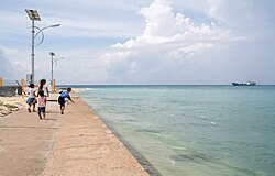 Young Vietnamese residents
 A military cemetery for Vietnamese soldiers on Central London Reef
 A view from Amboyna Cay
 The Pearson Reef dock under Vietnam's administration
.jpg)


_-_Geographicus_-_EastIndies-cary-1801.jpg)


