
Category:Welshpool
town in Powys, Wales, UK  | |||||
| Upload media | |||||
| Pronunciation audio | ⓘ | ||||
|---|---|---|---|---|---|
| Instance of | |||||
| Location | Powys, Wales | ||||
| Located in or next to body of water | |||||
| Heritage designation |
| ||||
| Population |
| ||||
 | |||||
Cymraeg: Mae'r Trallwng ( Saesneg: Welshpool) yn dref yng ngogledd-ddwyrain Powys, ger y ffin â Lloegr.
Deutsch: Welshpool (walisisch: Y Trallwng) ist eine Stadt in der walisischen Grafschaft Powys; sie liegt im Tal des Flusses Severn und besitzt seit 1263 Marktrecht.
English: Welshpool (Welsh: Y Trallwng) is a town in the northeast of Powys, not far from the Wales-England border. The town is low-lying on the River Severn; the Welsh language name literally meaning 'the marshy or sinking land'.
Subcategories
This category has the following 15 subcategories, out of 15 total.
B
- Beacon Ring (23 F)
- Belan, Powys (16 F)
E
G
- Gorsedd stones, Welshpool (10 F)
H
L
- Welshpool livestock market (23 F)
P
S
T
W
Media in category "Welshpool"
The following 200 files are in this category, out of 1,461 total.
(previous page) (next page)-
 "Anderson Shelter", Dingle Gardens - geograph.org.uk - 2605494.jpg 640 × 480; 121 KB
-
 1 Mount Street, Welshpool - geograph.org.uk - 7268276.jpg 4,958 × 3,304; 6.08 MB
-
 Winifred Maxwell, Countess of Nithsdale.jpg 488 × 600; 56 KB
-
 18 Severn Street, Welshpool - geograph.org.uk - 7266165.jpg 5,184 × 3,456; 6.14 MB
-
-
 A basin on the Montgomery Canal - geograph.org.uk - 6589844.jpg 1,024 × 768; 742 KB
-
 A cock in the Cockpit - geograph.org.uk - 6009884.jpg 1,024 × 768; 206 KB
-

-
 A field of maize near Sarn-y-bryn-caled - geograph.org.uk - 3155722.jpg 3,872 × 2,592; 1.91 MB
-
 A Peacock, with its tail-feathers fully fanned - geograph.org.uk - 7040709.jpg 1,024 × 768; 270 KB
-
 A Powis Peacock - geograph.org.uk - 5272514.jpg 3,675 × 2,440; 2.98 MB
-
 A replacement Montgomery Canal Milepost - geograph.org.uk - 8170918.jpg 2,048 × 2,048; 1.53 MB
-
 A yew trimmer at work - geograph.org.uk - 6307824.jpg 1,024 × 1,024; 1.68 MB
-
 A. C. Roof Trusses - geograph.org.uk - 4633088.jpg 640 × 426; 52 KB
-
 A.C. Roof Trusses, Welshpool - geograph.org.uk - 4720869.jpg 800 × 493; 86 KB
-
 A458 Approaching Welshpool - geograph.org.uk - 5492655.jpg 640 × 480; 394 KB
-
 A458 at New Lane junction - geograph.org.uk - 4824951.jpg 640 × 458; 61 KB
-
 A458 bridge over Montgomery Canal at Ty-Gwyn - geograph.org.uk - 7539699.jpg 4,000 × 3,000; 4.76 MB
-
 A458 bridge over Montgomery Canal, Welshpool - geograph.org.uk - 7539978.jpg 4,000 × 3,000; 4.78 MB
-
 A458 entering Welshpool - geograph.org.uk - 8016053.jpg 640 × 262; 76 KB
-
 A458 near Coed-y-dinas - geograph.org.uk - 5492635.jpg 640 × 480; 415 KB
-
 A458 roundabout, Welshpool - geograph.org.uk - 7569115.jpg 3,564 × 2,565; 4.24 MB
-
 A458 Salop Road at Waterloo Place - geograph.org.uk - 3959163.jpg 640 × 481; 56 KB
-
 A458 Welshpool bypass - geograph.org.uk - 4498361.jpg 1,600 × 1,200; 1.28 MB
-
 A483 - geograph.org.uk - 4437781.jpg 640 × 426; 58 KB
-
 A483 - geograph.org.uk - 4437787.jpg 640 × 426; 71 KB
-
 A483 - geograph.org.uk - 4437788.jpg 640 × 426; 58 KB
-
 A483 - geograph.org.uk - 4437789.jpg 640 × 426; 73 KB
-
 A483 - geograph.org.uk - 4437790.jpg 640 × 426; 65 KB
-
 A483 - geograph.org.uk - 4437805.jpg 640 × 426; 75 KB
-
 A483 - geograph.org.uk - 4437837.jpg 640 × 426; 67 KB
-
 A483 and barns at Weir Head - geograph.org.uk - 7115576.jpg 4,032 × 3,024; 2.02 MB
-
 A483 at Plas Tehelig - geograph.org.uk - 7540308.jpg 4,000 × 2,661; 3.43 MB
-
 A483 at Pool Quay village boundary - geograph.org.uk - 3289652.jpg 640 × 481; 43 KB
-
 A483 at Pool Quay, Powys - geograph.org.uk - 1921330.jpg 1,024 × 768; 236 KB
-
 A483 heading north - geograph.org.uk - 3289554.jpg 640 × 480; 44 KB
-
 A483 heading north - geograph.org.uk - 3959179.jpg 640 × 480; 45 KB
-
 A483 Leaving Welshpool - geograph.org.uk - 5498375.jpg 640 × 480; 311 KB
-
 A483 near Buttington - geograph.org.uk - 5498388.jpg 640 × 480; 409 KB
-
 A483 near Coed-Y-Dinas - geograph.org.uk - 5491741.jpg 640 × 427; 327 KB
-
 A483 near Court Farm - geograph.org.uk - 3289532.jpg 640 × 480; 64 KB
-
 A483 near Moors Farm - geograph.org.uk - 5498392.jpg 640 × 480; 393 KB
-
 A483 near The Moat Farm - geograph.org.uk - 3289549.jpg 640 × 480; 34 KB
-
 A483 near The Moat Farm - geograph.org.uk - 7883548.jpg 640 × 480; 58 KB
-
 A483 near to Llwynderw - geograph.org.uk - 5491735.jpg 640 × 480; 416 KB
-
 A483 near to Pool Quay - geograph.org.uk - 5501285.jpg 640 × 480; 359 KB
-
 A483 near Weir End - geograph.org.uk - 3289650.jpg 640 × 481; 54 KB
-
 A483 near Welshpool - geograph.org.uk - 5498378.jpg 640 × 480; 380 KB
-
 A483 near Wernllwyd - geograph.org.uk - 3289517.jpg 640 × 480; 51 KB
-
 A483 north east of Welshpool - geograph.org.uk - 2227932.jpg 640 × 480; 50 KB
-
 A483 north of Plas Trehelig - geograph.org.uk - 7540310.jpg 4,000 × 2,659; 3.87 MB
-
 A483 north of Pool Quay - geograph.org.uk - 3289654.jpg 640 × 480; 62 KB
-
 A483 north of Pool Quay - geograph.org.uk - 5501291.jpg 640 × 480; 356 KB
-
 A483 north of Welshpool - geograph.org.uk - 5498380.jpg 640 × 480; 302 KB
-
 A483 South near Court Farm - geograph.org.uk - 7777574.jpg 640 × 408; 77 KB
-
 A483 south of Welshpool - geograph.org.uk - 7540313.jpg 4,000 × 3,203; 4.12 MB
-
 A483 through the trees - geograph.org.uk - 4437838.jpg 640 × 426; 94 KB
-
 A483 towards Newtown - geograph.org.uk - 7810288.jpg 4,032 × 3,024; 2.51 MB
-
 A483 towards Newtown - geograph.org.uk - 7810290.jpg 4,032 × 3,024; 2.83 MB
-
 A483 towards Welshpool - geograph.org.uk - 7883543.jpg 640 × 484; 69 KB
-
 A483 towards Welshpool - geograph.org.uk - 7883559.jpg 640 × 482; 67 KB
-
 A483 Welshpool bypass looking north - geograph.org.uk - 2227927.jpg 640 × 480; 55 KB
-
 A483, Pool Quay - geograph.org.uk - 5501287.jpg 640 × 480; 394 KB
-
 A490 at entrance to Brookfield Hall - geograph.org.uk - 3133382.jpg 640 × 472; 111 KB
-
 A490 at Windmill Lane junction - geograph.org.uk - 3133386.jpg 640 × 452; 73 KB
-
 A490 flooded - geograph.org.uk - 3842704.jpg 1,280 × 851; 367 KB
-
 A490 flooded - geograph.org.uk - 3851982.jpg 1,280 × 851; 308 KB
-
 A490 lane junction near Groespluan - geograph.org.uk - 3953776.jpg 640 × 481; 28 KB
-
 A490 southbound near Homleigh - geograph.org.uk - 3953764.jpg 640 × 480; 51 KB
-
 A490 towards Forden - geograph.org.uk - 7883564.jpg 640 × 477; 59 KB
-
 Abbey Terrace on Salop Road - geograph.org.uk - 4589615.jpg 640 × 480; 75 KB
-

-
 Absolutely Fabulous in Welshpool - geograph.org.uk - 4722568.jpg 800 × 556; 123 KB
-
 Access road to Welshpool Police Station - geograph.org.uk - 4751957.jpg 800 × 719; 208 KB
-
 Acers on the slope down to the Great Lawn - geograph.org.uk - 7040753.jpg 1,024 × 768; 238 KB
-
 Acers on the slope next to the Bothy House - geograph.org.uk - 7040758.jpg 1,024 × 768; 238 KB
-
-
-
 Afon Hafren - geograph.org.uk - 691133.jpg 640 × 392; 66 KB
-
 Afon Hafren - Severn River - geograph.org.uk - 4522846.jpg 640 × 415; 54 KB
-
 Alleyway leading up to Broad Street - geograph.org.uk - 1560802.jpg 480 × 640; 97 KB
-
 Almshouses in Welshpool - geograph.org.uk - 4751989.jpg 800 × 663; 165 KB
-
 An Isolated tree - geograph.org.uk - 4633096.jpg 640 × 426; 44 KB
-
 An Ox Bow Lake - geograph.org.uk - 4633094.jpg 640 × 426; 47 KB
-
 Apple trees at Powis - geograph.org.uk - 7060847.jpg 1,024 × 768; 194 KB
-
 Approaching a roundabout on the A483 in Welshpool - geograph.org.uk - 2084567.jpg 3,723 × 2,475; 1.94 MB
-
 Approaching roundabout on the A483 - geograph.org.uk - 7883549.jpg 640 × 480; 60 KB
-
 Approaching the gateway entrance to Powis Castle - geograph.org.uk - 7118607.jpg 4,000 × 3,000; 2.88 MB
-
 Approaching Welshpool - geograph.org.uk - 1470719.jpg 640 × 480; 150 KB
-
 Approaching Welshpool - geograph.org.uk - 8067898.jpg 1,920 × 1,440; 671 KB
-
 Approaching Welshpool on Glyndwr's Way - geograph.org.uk - 4672828.jpg 4,608 × 3,456; 4.01 MB
-
 Army football teams who played each other at Welshpool (1484038).jpg 1,848 × 1,196; 376 KB
-

-
 At home in Llyn Coed Y Dinas - geograph.org.uk - 781969.jpg 640 × 394; 105 KB
-
 At Top Lock at Pool Quay - geograph.org.uk - 7613455.jpg 640 × 480; 94 KB
-
 Autumn along the canal - geograph.org.uk - 3183826.jpg 640 × 480; 117 KB
-
 Autumn colour at Powis - geograph.org.uk - 7046796.jpg 1,024 × 768; 234 KB
-
 Autumn colour at Powis - geograph.org.uk - 7046848.jpg 1,024 × 768; 275 KB
-

-
 Autumn scene near Cwm Lane - geograph.org.uk - 1560208.jpg 640 × 426; 66 KB
-
 B4381 bridge over Montgomery Canal, Welshpool - geograph.org.uk - 7539989.jpg 4,000 × 3,000; 4.85 MB
-
 B4381 direction signs, Welshpool - geograph.org.uk - 4755918.jpg 800 × 633; 160 KB
-
 Banana plants below the Castle wall - geograph.org.uk - 7054943.jpg 1,024 × 768; 238 KB
-
 Barge at Belan Locks - geograph.org.uk - 7539227.jpg 3,978 × 2,780; 4.89 MB
-

-
 Barn at The Coppice - geograph.org.uk - 7613471.jpg 640 × 480; 95 KB
-
 Barn near Wernllwyd - geograph.org.uk - 7540290.jpg 4,000 × 3,000; 4.62 MB
-
 Barn, northeast of Pen-y-Golfa - geograph.org.uk - 7258924.jpg 4,032 × 3,024; 4.39 MB
-
 Bayley Bank T5 and T6 - information poster - geograph.org.uk - 6958184.jpg 768 × 1,024; 508 KB
-
 Belan Bottom Lock - geograph.org.uk - 7539628.jpg 4,032 × 3,024; 4.36 MB
-
 Belan Bottom Lock, Montgomery Canal - geograph.org.uk - 4320407.jpg 800 × 534; 124 KB
-
 Belan church at Llwynderw - geograph.org.uk - 7539222.jpg 4,000 × 3,000; 4.79 MB
-
 Belan Home Guard, Welshpool (1448803).jpg 1,848 × 1,196; 462 KB
-
 Belan Home Guard, Welshpool (1448804).jpg 1,848 × 1,196; 388 KB
-
 Belan Home Guard, Welshpool (1448805).jpg 1,848 × 1,196; 317 KB
-
 Belan Lock on the Montgomery Canal - geograph.org.uk - 6180009.jpg 640 × 480; 104 KB
-
 Belan Locks in a June rain storm - geograph.org.uk - 6180019.jpg 640 × 480; 62 KB
-
 Belan Locks on Montgomery Canal - geograph.org.uk - 7539226.jpg 4,000 × 3,000; 4.58 MB
-
 Belan Top Lock, Montgomery Canal - geograph.org.uk - 4320442.jpg 800 × 534; 129 KB
-
 Bench in a hedge - geograph.org.uk - 8069598.jpg 1,920 × 1,440; 728 KB
-

-
 Bend near Golfa Farm - geograph.org.uk - 1560215.jpg 640 × 426; 112 KB
-
 Berriew Road, Welshpool - geograph.org.uk - 5492660.jpg 640 × 480; 425 KB
-
 Berriew Street - geograph.org.uk - 8068601.jpg 1,920 × 1,640; 494 KB
-
 Beside Lledan Brook - geograph.org.uk - 2192849.jpg 640 × 480; 142 KB
-
 Beside the Welshpool by-pass - geograph.org.uk - 6290890.jpg 1,024 × 576; 279 KB
-
 Bird sculptures at Powysland Museum - geograph.org.uk - 7106891.jpg 1,024 × 768; 530 KB
-
 Bird sculptures at Powysland Museum - geograph.org.uk - 7106899.jpg 1,024 × 768; 521 KB
-
 Black and White - geograph.org.uk - 978015.jpg 640 × 457; 146 KB
-
 Blackpool Woods - geograph.org.uk - 5031046.jpg 1,024 × 768; 130 KB
-
 Boat hidden in greenery - geograph.org.uk - 4589593.jpg 640 × 480; 199 KB
-
 Bodhilin, Montgomeryshire. The Property of John Humphreys Esqr.jpeg 900 × 659; 420 KB
-

-
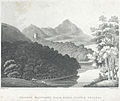 Breddyn Mountains from Powis Castle Grounds.jpeg 900 × 754; 371 KB
-
 Bridge 116 over Montgomery Canal - geograph.org.uk - 4589575.jpg 640 × 480; 144 KB
-
 Bridge 119 crossing the Montgomeryshire Canal - geograph.org.uk - 6586904.jpg 1,024 × 768; 781 KB
-
 Bridge 121 over Montgomery Canal at Belan - geograph.org.uk - 7540118.jpg 4,000 × 3,000; 4.74 MB
-
 Bridge 122 over Montgomery Canal - geograph.org.uk - 7539224.jpg 4,000 × 3,000; 4.96 MB
-
 Bridge across stream at Cloddiau - geograph.org.uk - 1314910.jpg 640 × 480; 131 KB
-

-
 Bridge No. 119 on the Montgomery Canal at Welshpool - geograph.org.uk - 7113622.jpg 4,000 × 3,000; 2.71 MB
-
 Bridge No.115, Montgomery Canal - geograph.org.uk - 7113785.jpg 4,000 × 3,000; 2.87 MB
-
 Bridge No.116, Montgomery Canal - geograph.org.uk - 7113779.jpg 4,000 × 3,000; 2.87 MB
-
 Bridge over Afon Hafren - geograph.org.uk - 6586889.jpg 1,024 × 768; 541 KB
-
 Bridge over Montgomery Canal near Wernllwyd - geograph.org.uk - 7538060.jpg 4,000 × 3,000; 4.92 MB
-
 Bridge over Nant Rhyd-y-Moch - geograph.org.uk - 2241557.jpg 640 × 480; 110 KB
-
 British Homing World, Welshpool - geograph.org.uk - 4720820.jpg 800 × 545; 97 KB
-
 Broad Street, Welshpool - geograph.org.uk - 7113586.jpg 4,000 × 3,000; 2.35 MB
-
 Brooks Cycles, Welshpool - geograph.org.uk - 4720181.jpg 800 × 713; 132 KB
-
 Builder's merchant, Welshpool - geograph.org.uk - 4437792.jpg 640 × 426; 72 KB
-
 Builder's merchant, Welshpool - geograph.org.uk - 4437793.jpg 640 × 426; 54 KB
-
 Building work in progress - geograph.org.uk - 7539638.jpg 4,032 × 3,024; 3.18 MB
-
 Buildings at The Moors farm - geograph.org.uk - 7115565.jpg 4,032 × 3,024; 2.35 MB
-
 Bullrushes, Montgomery Canal - geograph.org.uk - 7113759.jpg 4,000 × 3,000; 2.69 MB
-
 Bungalows by the canal - geograph.org.uk - 3183854.jpg 640 × 480; 85 KB
-
 Bus shelter by A458 south of Welshpool - geograph.org.uk - 4498415.jpg 1,600 × 1,200; 1.45 MB
-
 Bus Stop on the A458 near Coed-y-dinas - geograph.org.uk - 5492629.jpg 640 × 427; 375 KB
-
 Buttington Roundabout - geograph.org.uk - 5508740.jpg 5,872 × 3,719; 6.16 MB
-
 Bwcedi tân - Fire buckets - geograph.org.uk - 7817022.jpg 3,605 × 3,605; 1.76 MB
-

-
 Canal behind Clerk's Close - geograph.org.uk - 3184977.jpg 640 × 480; 106 KB
-

-

-
 Canal Boat on Montgomery Canal - geograph.org.uk - 3183412.jpg 640 × 480; 107 KB
-

-
 Canal bridge at Llwynderw - geograph.org.uk - 7539221.jpg 4,000 × 3,000; 4.83 MB
-

-
 Canal looking towards Severn Street - geograph.org.uk - 4067260.jpg 640 × 480; 80 KB
-
 Canal Mile Marker, Welshpool (geograph 7652172).jpg 768 × 1,024; 201 KB
-
 Canal milemarker, Montgomery Canal (geograph 7540003).jpg 3,000 × 4,000; 4.78 MB
-
 Canal narrows under old railway bridge - geograph.org.uk - 2469309.jpg 640 × 480; 123 KB
-
 Canal reflections - geograph.org.uk - 4589601.jpg 640 × 480; 149 KB
-
 Canal Reflections - geograph.org.uk - 791423.jpg 480 × 640; 66 KB
-

-
 Canal side sculpture - geograph.org.uk - 791437.jpg 480 × 640; 109 KB
-
 Canal towards Welshpool wharf - geograph.org.uk - 4589605.jpg 640 × 480; 110 KB
-
 Canal towpath, Montgomery Canal, Welshpool - geograph.org.uk - 7539985.jpg 4,000 × 3,000; 4.16 MB
-

-
 Canal wharf, Welshpool - geograph.org.uk - 7539973.jpg 4,000 × 3,000; 5.15 MB
-
 Canal, road and sheep - geograph.org.uk - 3155835.jpg 3,872 × 2,592; 4.36 MB
-
 Canalside sculpture, Welshpool - geograph.org.uk - 1587584.jpg 480 × 640; 111 KB
-
 Car park and driveway, Powis Castle - geograph.org.uk - 4908608.jpg 2,048 × 1,536; 759 KB
-
 Car park at Powis Castle - geograph.org.uk - 7600298.jpg 4,080 × 3,072; 5.6 MB
-
 Car Park by Mill Lane bridge - geograph.org.uk - 4589607.jpg 640 × 480; 65 KB
-
 Carpark at Welshpool Livestock Sales - geograph.org.uk - 7439397.jpg 4,032 × 3,024; 2.21 MB
-
 Cars parked in a turning area, Welshpool - geograph.org.uk - 4720893.jpg 800 × 544; 107 KB
-
 CEF premises and van, Welshpool - geograph.org.uk - 4720864.jpg 800 × 573; 101 KB
-
 Cefnyspin Lane, Near Welshpool - geograph.org.uk - 212496.jpg 640 × 480; 190 KB
-
 Ceiliog Paun - Peacock - geograph.org.uk - 7815897.jpg 3,898 × 3,118; 3.23 MB
-
 Ceunant Farm from A490 - geograph.org.uk - 3133388.jpg 640 × 418; 50 KB
-
 Check rail on the sharp curve - geograph.org.uk - 2560736.jpg 1,024 × 768; 210 KB
-
 Chelsea Lane Baptist Church - geograph.org.uk - 1791262.jpg 640 × 480; 66 KB
-
 Children paddling at Welshpool Lido (1501056).jpg 1,848 × 1,196; 386 KB
-
 Children paddling at Welshpool Lido (1501057).jpg 1,848 × 1,196; 425 KB
-
 Children paddling at Welshpool Lido (1501058).jpg 1,848 × 1,196; 413 KB
-
 Children paddling at Welshpool Lido (1501059).jpg 1,848 × 1,196; 406 KB
-
 Children paddling at Welshpool Lido (1501060).jpg 1,848 × 1,196; 422 KB
-
 Children paddling at Welshpool Lido (1501061).jpg 1,848 × 1,196; 425 KB
-
 Children warning sign, Welshpool - geograph.org.uk - 4719623.jpg 800 × 800; 199 KB
-
 Children's playground - geograph.org.uk - 613538.jpg 640 × 480; 123 KB


_from_Maginnis_Bridge_-_geograph.org.uk_-_582593.jpg)


.jpg)


.jpg)
.jpg)
.jpg)


.jpg)
.jpg)


.jpg)
.jpg)
.jpg)
.jpg)
.jpg)
.jpg)

