
Category:RAF Martlesham Heath
English: RAF Martlesham Heath is a former Royal Air Force airfield located near Woodbridge, Suffolk, England.
| Object location | | View all coordinates using: OpenStreetMap |
|---|
former RAF station 1917–1963  | |||||
| Upload media | |||||
| Instance of | |||||
|---|---|---|---|---|---|
| Location | England | ||||
| Operator | |||||
| Inception |
| ||||
| Dissolved, abolished or demolished date |
| ||||
 | |||||
Subcategories
This category has the following 2 subcategories, out of 2 total.
R
Media in category "RAF Martlesham Heath"
The following 44 files are in this category, out of 44 total.
-
 Martheath-July946.png 600 × 642; 454 KB
-
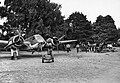
 356fg-martlesham-1944.jpg 3,096 × 2,064; 2.44 MB
-
 AFB1SideView.jpg 2,500 × 1,075; 454 KB
-
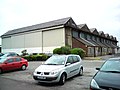 Aircraft Hangar - geograph.org.uk - 1323144.jpg 640 × 480; 104 KB
-
-

-
-
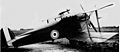
 Bristol Boarhound I.jpg 1,251 × 643; 240 KB
-
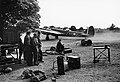
 Chemical Warfare in the Twentieth Century CH3995.jpg 3,307 × 2,480; 2.21 MB
-
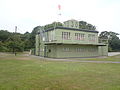
 Control Tower Martlesham Heath - geograph.org.uk - 1860026.jpg 640 × 480; 59 KB
-
 Control Tower Museum ^ Base Marker - geograph.org.uk - 2857883.jpg 3,072 × 2,304; 1.52 MB
-
 Control Tower Museum, Martlesham Heath - geograph.org.uk - 2833697.jpg 3,072 × 2,304; 1.34 MB
-
 Control Tower Museum, Martlesham Heath - geograph.org.uk - 2833698.jpg 3,072 × 2,304; 1.5 MB
-
 Control Tower Museum, Martlesham Heath - geograph.org.uk - 2833744.jpg 3,072 × 2,304; 1.41 MB
-
 Control Tower Museum, Martlesham Heath - geograph.org.uk - 2858601.jpg 3,072 × 2,304; 1.63 MB
-
 Ex-RAF Martlesham Heath Station Commander's house - geograph.org.uk - 5053642.jpg 3,456 × 2,592; 3.81 MB
-
 Ex-Station Headquarters RAF Martlesham Heath - geograph.org.uk - 5053633.jpg 3,456 × 2,592; 3.96 MB
-
 Former Martlesham Heath Airfield Control Tower - geograph.org.uk - 5620364.jpg 5,184 × 2,920; 5.55 MB
-
 Former RAF housing at Martlesham Heath - geograph.org.uk - 6524636.jpg 5,579 × 3,719; 4.6 MB
-
 Hatch covers in the woods - geograph.org.uk - 1339627.jpg 640 × 480; 155 KB
-

-
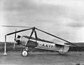 IWM-ATP7178C Cierva C19 205127200.jpg 800 × 617; 181 KB
-
 IWM-ATP8143C Cierva C30A 205127566.jpg 800 × 601; 195 KB
-
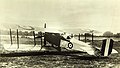 Martinsyde F1.jpg 1,920 × 1,085; 266 KB
-

-
 Martlesham Heath airfield control tower.JPG 2,592 × 1,944; 1.29 MB
-
 Martlesham Heath Former RAF Quarters - geograph.org.uk - 4004503.jpg 1,024 × 683; 232 KB
-
 Martlesham Huts2 (89322543).jpeg 1,620 × 1,080; 796 KB
-
 No longer Martlesham Barracks - geograph.org.uk - 6222322.jpg 1,836 × 1,140; 1.02 MB
-

-

-
 Once the Barracks Blocks of RAF Martlesham Heath - geograph.org.uk - 5049346.jpg 3,456 × 2,592; 3.76 MB
-
 One of the old hangars of ex-RAF Martlesham Heath - geograph.org.uk - 5053657.jpg 3,456 × 2,592; 3.86 MB
-
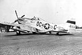 P-51 Mustang - Martlesham - 356fg-p51.jpg 600 × 406; 47 KB
-
 P-51-356fg.jpg 1,500 × 1,000; 318 KB
-

-
 Royal Air Force Fighter Command, 1939-1945. CH1670.jpg 800 × 615; 48 KB
-
 Royal Air Force Fighter Command, 1939-1945. CH4000.jpg 800 × 609; 68 KB
-
 Site of Martlesham Heath airfield - geograph.org.uk - 1219418.jpg 640 × 480; 120 KB
-

-

-
 The Battle of Britain 1940 CH1681.jpg 2,406 × 1,772; 801 KB
-
 Vickers 131 001.jpg 1,347 × 551; 369 KB
-
 WWII pillbox on ancient round barrow - geograph.org.uk - 1817646.jpg 640 × 480; 116 KB


.jpeg)


